Updated Tuesday Morning Forecast — September 11th, 2018

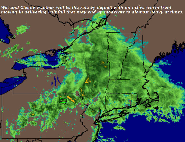
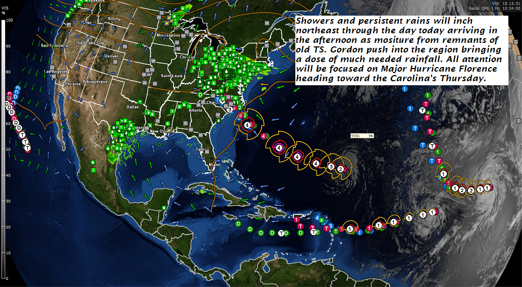
TODAY: Mainly cloudy. Showers this morning becoming isolated to widely scattered this afternoon especially southern areas. Start of a warming trend. A high in the mid to upper 60s. Light south winds.

TONIGHT: Partly to mostly cloudy. Isolated showers especially toward Rutland. Patchy valley fog. A low upper 50s to near 60. Light north winds.

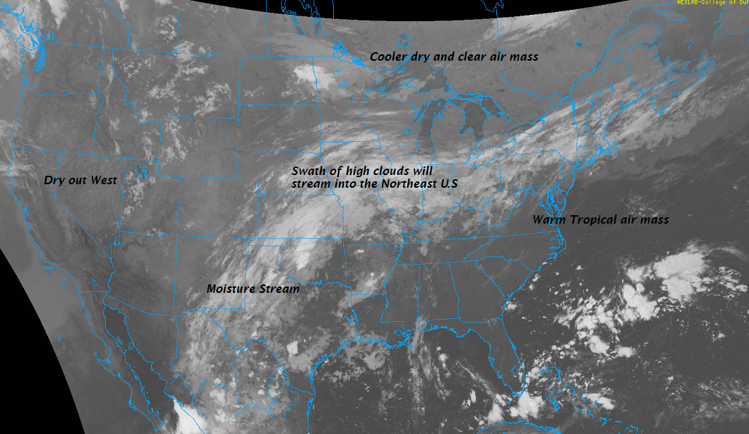
WEDNESDAY: Considerable morning cloudiness giving way to breaks of sunshine. A few mountain sprinkles or brief showers southern areas. A high in the low 70s. Little wind.

Looking further ahead…

WEDNESDAY NIGHT: Mainly cloudy. Slight chance for sprinkles or areas of drizzle. A low in the low 60s.

THURSDAY: Morning fog burns off to more sun than clouds. A high 75 to 80.

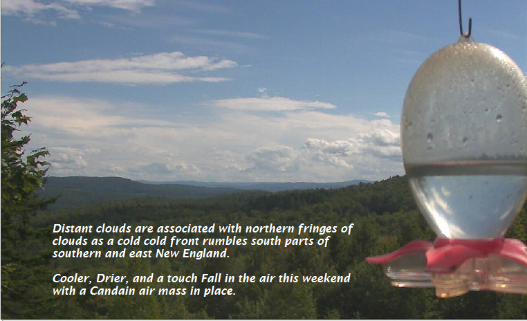
FRIDAY: Pick of the week. Morning fog then mostly sunny with a few more clouds southern areas. A low 60 to 65. A high near 80.

SATURDAY: Morning fog, then partly to mostly sunny. A low around 65. A high around 80.

SUNDAY: Morning fog, then mostly sunny with a few more afternoon clouds. A low 60 to 65. A high in the low 80s.

Average lows in the mid 40s to mid 50s. Normal highs in the upper 60s to mid 70s.

RH/9-10-18[end]

Virus-free. www.avast.com

Updated Monday Evening Forecast — September 10th, 2018

TONIGHT: Periods of rain or showers, possibly heavy at times across northern area after midnight. A low in the mid 50s. Southeast winds 10 to 15 mph.

TOMORROW: Mainly cloudy. Showers with a risk for a few rumbles of thunder. Start of a warming trend. A high in the mid 60s. Light south winds.

TUESDAY NIGHT: Partly to mostly cloudy. A few lingering showers toward southern areas. Patchy valley fog. A low upper 50s to low 60s. Light north winds.

WEDNESDAY: Considerable morning cloudiness giving way to breaks of sunshine. Slight chance for a mountain sprinkle. A high around 70. Little wind.

Looking further ahead…

WEDNESDAY NIGHT: Mainly cloudy. Slight chance for sprinkles or areas of drizzle. A low in the low 60s.

THURSDAY: Morning fog burns off to partial afternoon sunshine. A high in the mid 70s.

FRIDAY: Pick of the week. Morning fog then partly to mostly sunny skies. A low in the low 60s. A high near 80.

SATURDAY: Morning fog, then mostly sunny. A low in the lower 60s. A high around 80.

SUNDAY: Morning fog, then mostly sunny. A low around 60. A high around 80.

Average lows in the mid 40s to mid 50s. Normal highs in the upper 60s to mid 70s.

RH/9-10-18[end]

Virus-free. www.avast.com

Updated Monday Morning Forecast — September 10th, 2018

TODAY: Thickening clouds leading to periods of showers developing south to north this afternoon. Continued rather chilly. A high around 60. Southeasterly breeze picking at 10 to 20 mph

TONIGHT: Periods of rain or showers, possibly heavy at times across northern areas. A low in the mid 50s. southeast winds 10 to 15 mph.

TUESDAY: Mainly cloudy. Showers with a risk for a few rumble of thunder. Start of a warming trend. A high in the mid 60s. Light south winds.

Looking further ahead…

TUESDAY NIGHT: Partly to mostly cloudy. A few lingering showers toward southern areas. Patchy valley fog. A low upper 50s to low 60s.

WEDNESDAY: Considerable morning cloudiness giving way to breaks of sunshine. A high in the upper 60s to around 70.

THURSDAY: Morning fog burns off to lots of sunshine. A low 55 to 60. A high 75 to 80.

FRIDAY: Pick of the week. Morning fog then bright sunshine and blue skies. A low 55 to 60. A high around 80.

Average lows in the mid 40s to mid 50s. Normal highs in the upper 60s to mid 70s.

RH/9-10-18[end]

Virus-free. www.avast.com

Updated Friday Evening Forecast — September 7th 2018

TONIGHT: Fair with patchy high cloudiness. A low in the low 50s. Light north winds.

TOMORROW: Morning fog then sunny with a few high clouds. Below normal temperature levels. A high 60 to 65. Northwest winds 10 to 15 mph.

Frost Advisory Northeast Kingdom cool spots Saturday night.

SATURDAY NIGHT: Fair and chilly with some high cloudiness at times. A low down to around 40. Light northeast winds.

SUNDAY: Filtered sunshine through high cloudiness. Clouding up late. Still cool. A high 60 to 65. Light northeast winds.

Looking further ahead…

SUNDAY NIGHT: Mostly fair in the evening then clouding up overnight. A low in the mid 40s to around 50.

MONDAY: Cloudy and gray. Good chance for showers moderate to heavy at times, with a risk for a few thunderstorms. A high in the low 60s.

TUESDAY: Chance for lingering showers, Otherwise mainly cloudy. A low upper 50s to around 60. A high in the mid 70s.

WEDNESDAY: Morning fog burns off to lots of sunshine. A low near 55. A high 70 to 75

THURSDAY: Variable cloudiness. A low in the 50s. A high pushing to near 80.

Average lows in the mid 40s to mid 50s. Normal highs in the upper 60s to mid 70s.

RH/9-7-18[end]

Virus-free. www.avast.com

Updated Friday morning Forecast — September 7th, 2018

TODAY: Morning fog burns off, then sunshine filtered by high cloudiness. Pleasant. A high in the mid 70s. Light west winds.

TONIGHT: Fair with patchy high cloudiness. A low in the low 50s. Light northwest winds.

SATURDAY: Morning fog then sunny with a few high clouds. Below normal temperature levels. A high 60 to 65. South breeze 10 mph.

Looking further ahead…

SATURDAY NIGHT: Fair and chilly with some high cloudiness at times. A low down to around 40.

SUNDAY: Filtered sunshine through high cloudiness. Clouding up late. Still cool. A high 60 to 65.

MONDAY: Cloudy and gray. Good chance for showers moderate to heavy at times, with a risk for a few thunderstorms. A low around 50. A high 60 to 65.

TUESDAY: Chance for lingering showers, Otherwise mainly cloudy. A low 55 to 60. A high in the low 70s.

WEDNESDAY: Morning fog burns off to lots of sunshine. A low 50 to 55. A high near 75.

THURSDAY: Variable cloudiness. A low 55 to 60. A high pushing to near 80.

Average lows in the mid 40s to mid 50s. Normal highs in the upper 60s to mid 70s.

RH/9-7-18[end]

Virus-free. www.avast.com

Updated Thursday Evening forecast — September 6th, 2018

TONIGHT: Fair with some high cloudiness. A low 50 to 55. Light northwest winds.

TOMORROW: Any fog burns off, then sunshine filtered by high clouds. Pleasant. A high in the mid 70s. Light west winds.

FRIDAY NIGHT: Fair with patchy high cloudiness. A low in the low 50s. Light northwest winds.

SATURDAY: Morning fog then sunny with a few high clouds. A high 60 to 65. South 10 mph.

Looking further ahead…

SATURDAY NIGHT: Fair and cool with some high cloudiness at times. A low in the upper 30s to mid 40s

SUNDAY: Filtered sunshine through high cloudiness. A high in the low to mid 60s.

MONDAY: Cloudy and gray. Chance for showers and a risk for a few thunderstorms possibly moderate to heavy. A low in the low 40s. A high low 60s.

TUESDAY: Chance for showers, Otherwise mostly cloudy. A low near 55. A high 65 to 70.

WEDNESDAY: Partly sunny. A low in the 50s. A high 70 to 75.

Average lows in the upper 40s to mid 50s. Normal highs in the upper 60s to upper 70s.

RH/9-5-18[end]

Virus-free. www.avast.com

Updated Thursday morning Forecast — September 6th, 2018

TODAY: A round of morning showers with a few embedded thunderstorms…briefly heavy. Otherwise partly cloudy, not as humid by late this afternoon. A high mid to upper 70s. Northwest winds 10 to 20 mph.

TONIGHT: Fair with some high cloudiness. A low 50 to 55. Light northwest winds.

FRIDAY: Any fog burns off, then sunshine filtered by high clouds. Pleasant. A high in the mid 70s. Light west winds.

Looking further ahead…

FRIDAY NIGHT: Fair with patchy high cloudiness. A low upper 40s to low 50s.

SATURDAY: Morning fog then sunny. A high 60 to 65.

SUNDAY: Filtered sunshine through high cloudiness. A low in the upper 30s to mid 40s. A high around 65.

MONDAY: Thickening clouds. A rising chance for showers…possibly moderate to heavy. A low around 50. A high low to mid 60s.

TUESDAY: Cloudy and gray. Chance for showers or periods of rain, possibly moderate at times. A low 55 to 60. A high around 75.

WEDNESDAY: A low around 60. A high 70 to 75.

Average lows in the upper 40s to mid 50s. Normal highs in the upper 60s to upper 70s.

RH/9-5-18[end]

Virus-free. www.avast.com

Updated Wednesday morning forecast — September 5th, 2018

Heat Advisories lower valleys expire at 7 PM…

TONIGHT: Clear early becoming partly cloudy. A rising chance for showers and isolated thunderstorms . A low around 70. Southwest winds 10 mph.

TOMORROW: Scattered morning showers with a chance for a thunderstorm…one or two briefly heavy. Increasing afternoon sunshine not as humid in the afternoon. A high mid to upper 70s. Northwest winds 10 to 20 mph.

THURSDAY NIGHT: Fair with some high cloudiness. A low in the mid 50s. Light northwest winds.

FRIDAY: Any fog burns off, then sunshine filtered by high clouds. Pleasant. A high in the mid 70s. Light west winds.

Looking further ahead…

FRIDAY NIGHT: Mostly clear. A low upper 40s to low 50s.

SATURDAY: Morning fog then sunny. A high in the low to mid 60s.

SUNDAY: Filtered sunshine through high cloudiness. A low in the upper 30s to low 40s. A high in the upper 60s to low 70s.

MONDAY: Filtered sunshine then thickening clouds. Chance for showers toward evening. A low 45 to 50. A high mid 60s to around 70.

TUESDAY: Cloudy and gray. Chance for showers, some could be heavy. A low around 55. A high around 75.

Average lows in the upper 40s to mid 50s. Normal highs in the upper 60s to upper 70s.

RH/9-5-18[end]

Virus-free. www.avast.com

Updated Wednesday morning Forecast — September 5th 2018

Heat Advisories lower valleys through early evening…

TODAY: Variable clouds near the Quebec border with a passing sprinkle early, otherwise partly to mostly sunny, hot and sticky. A high 85 to 90. Southwest winds 10 to 15 mph.

TONIGHT: Partly cloudy. A rising chance for showers and isolated thunderstorms . A low around 70. Southwest winds 10 mph.

THURSDAY: Morning showers with a chance for thunderstorms…one or two briefly strong and locally heavy. Increasing afternoon sunshine not as humid in the afternoon. A high in the upper 70s to around 80. Northwest winds 10 to 20 mph.

Looking further ahead…

THURSDAY NIGHT: Mostly clear. A low in the mid 50s.

FRIDAY: Morning fog then sunshine filtered by high clouds. Cooler with low humidity. A high in the low to mid 70s.

SATURDAY: Morning fog then sunny. A low mid 40s to low 50s. A high mid 60s to low 70s.

SUNDAY: Filtered sunshine through high cloudiness. A low in the upper 30s to mid 40s. A high in the upper 60s to low 70s.

MONDAY: Filtered sunshine through high clouds. Pleasant. A low in the 50s. A high in the 70s.

TUESDAY: Mostly cloudy. A chance for showers. A low in the 50s. A high in the 70s.

Average lows in the upper 40s to mid 50s. Normal highs in the upper 60s to upper 70s.

RH/9-5-18[end]

Virus-free. www.avast.com

Updated Tuesday Night Forecast — September 4th, 2018

TONIGHT: Mostly clear with some high cloudiness overnight. A low in the lower 60s. Little wind.

TOMORROW: Filtered sunshine through high clouds. Warmer and more sticky in the afternoon. A high 85 to 90. Southwest winds 10 to 15 mph.

WEDNESDAY NIGHT: Partly cloudy. A rising chance for showers and isolated thunderstorms . A low around 70. Southwest winds 10 mph.

THURSDAY: Morning showers with a chance for a thunderstorm, then increasing afternoon sunshine not as humid in the afternoon. A high in the upper 70s to around 80.

Northwest winds 10 to 20 mph.

Looking further ahead…

THURSDAY NIGHT: Mostly clear. A low in the mid 50s.

FRIDAY: Morning fog then sunshine filtered by high clouds. Cooler with low humidity. A high in the low to mid 70s.

SATURDAY: Morning fog then sunny. A low mid 40s to low 50s. A high mid 60s to low 70s.

SUNDAY: Filtered sunshine through high cloudiness. A low in the upper 30s to mid 40s. A high in the upper 60s to low 70s.

Average lows in the upper 40s to mid 50s. Normal highs in the upper 60s to upper 70s.

RH/9-4-18[end]

Virus-free. www.avast.com