Updated Monday morning Forecast — October 15th, 2018

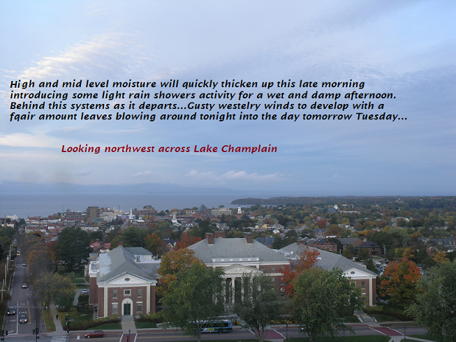
TODAY: Clouding up this morning with light rain showers developing toward mid day. A high in the low to mid 50s. South winds 10 to 15 mph.

TONIGHT: Scattered light rain showers tapering off this evening. Becoming partly cloudy and rather blustery. A low 35 to 40. Wind shifting to westerly 10 to 25 mph with higher gusts across the high terrain.

TUESDAY: Morning sunshine then partly cloudy in the afternoon. A high upper 40s to near 50. West to northwest 10 to 20 mph and gusty.

Looking further ahead…

TUESDAY NIGHT: Mostly clear early, then clouding up. A few light rain showers…possibly mixed with wet snow flakes Greens Mountain summits. A low in the mid to upper 30s

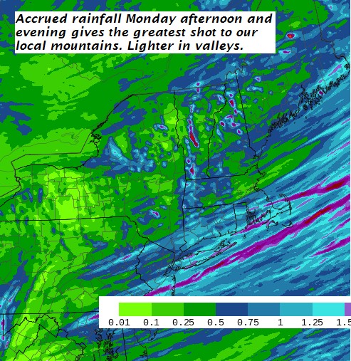
WEDNESDAY: Mostly cloudy. Chance for a light rain showers. A high near 50.

THURSDAY: Scattered showers of rain mixed with wet snow early…in the early morning hours. Perhaps a minor coating on grassy surfaces mostly elevated terrain. Showers depart to partial afternoon sunshine and blustery. A low in the around 30. A high in the mid to upper 30s.

FRIDAY: Maybe a few mixed rain or snow showers early, then partial clearing. A low around 35. A high in the mid 50s.

Average lows mid 30s to near 40. Normal highs in the mid to upper 50s

RH/10-15-18[end]

Virus-free. www.avast.com

Updated Friday Evening forecast — October 12th, 2018

TONIGHT: Partly cloudy this evening, then increasing clouds. A sprinkle or spotty light rain toward daybreak. A low around 40. Light northwest winds.

TOMORROW: A mainly cloudy raw day. Some spotty light rain or sprinkles exiting late in the afternoon. Temperatures peaking in the mid to upper 40s. West to northwest breeze 10 to 20 mph.

SATURDAY NIGHT: Lots of clouds areas of fog and with a slight threat for frost. A low in the mid 30s. Light west winds.

SUNDAY: Morning sun with afternoon cloudiness. Chilly. A high 50 to 55. West winds 10 to 15 mph.

Looking further ahead…

SUNDAY NIGHT: Fair early then clouding up overnight. A low near 40.

MONDAY: Mainly cloudy. Chance for light rain or showers. A high in the low to mid 50s.

TUESDAY: Clouds mixing with intervals of sun. A low 35 to 40. A high around 50.

WEDNESDAY: Cloudy. Chance for light rain showers. A low in the mid to upper 30s. A high near 50.

THURSDAY: Mostly cloudy. Scattered rain or snow showers with a dusting possible grassy surfaces early. A low near freezing or 32 degrees. A high near 40.

Average lows upper 30s to low 40s. Normal highs mid 50s to 60

RH/10-12-18[end]

Updated Friday morning Forecast — October 12th, 2018

TODAY: Lot of clouds with a few breaks of sun. A high in the low 50s. Northwest winds 10 to 15 mph.

TONIGHT: Mainly cloudy. Chance for a sprinkle developing toward daybreak. A low around 40. Light northwest winds.

SATURDAY: Lots of clouds and rather raw. An occasional light rain shower or sprinkle. Chilly high peaking in the mid 40s. West to northwest breeze 10 to 20 mph.

Looking further ahead…

SATURDAY NIGHT: Lots of clouds areas of fog and with a slight threat for frost. A low in the mid 30s.

SUNDAY: Morning sun with afternoon cloudiness. Chilly. A high 50 to 55.

MONDAY: Mainly cloudy. Chance for light rain or showers. A low near 40. A high in the low to mid 50s.

TUESDAY: Clouds mixing with intervals of sun. A low 35 to 40. A high around 50.

WEDNESDAY: Cloudy. Chance for light rain showers. A low in the mid to upper 30s. A high near 50.

THURSDAY: Mostly cloudy. Scattered rain or snow showers with a dusting possible grassy surfaces early. A low near freezing or 32 degrees. A high near 40.

Average lows upper 30s to low 40s. Normal highs mid 50s to 60

RH/10-12-18[end]

Virus-free. www.avast.com

Updated Thursday Evening Forecast — October 11th, 2018

TONIGHT: Evening showers exit later but remaining cloudy. Patchy valley fog. A low upper 40s. West breeze 10 mph.

TOMORROW: Lot of clouds with a few breaks of sun. A high in the low 50s. Northwest winds 10 to 15 mph.

FRIDAY NIGHT: Mostly cloudy. A low in the upper 30s to around 40. Light northwest winds.

SATURDAY: Lots of clouds and rather raw with occasional rain showers. Chilly high peaking in the mid 40s. West to northwest breeze 10 to 20 mph.

Looking further ahead…

SATURDAY NIGHT: Lots of clouds areas of fog and slight threat for frost.

SUNDAY: Morning sun with afternoon cloudiness. Chilly. A high around 50.

MONDAY: Mainly cloudy. Chance for light rain or showers. A low near 40. A high around 50.

TUESDAY: Clouds mixing with intervals of sun. A low 35 to 40. A high around 50.

WEDNESDAY: Cloudy. Chance for showers. A low in the mid to upper 30s. A high near 50.

Average lows upper 30s to low 40s. Normal highs mid 50s to 60

RH/10-11-18[end]

Virus-free. www.avast.com

Updated Thursday morning forecast — October 11th, 2018

TODAY: Gray with showers…some moderate at times, A high in the mid 60s. South winds 10 to 15 mph.

TONIGHT: Early evening showers exiting. Leftover cloudiness. A low upper 40s. West breeze 10 mph.

FRIDAY: Lot of clouds with a few breaks of afternoon sun. A high around 55. Northwest winds 10 to 15 mph.

Looking further ahead…

FRIDAY NIGHT: Mostly cloudy. A low 35 to 40.

SATURDAY: Gray skies. Chance for spotty light rain. Very chilly and below normal temperatures. A high around 45.

SUNDAY: Morning sun with afternoon cloudiness. Chilly. A low 30 to 35 with a good chance for widespread frost. A high around 50.

MONDAY: Mainly cloudy. Chance for light rain or showers. A low near 40. A high 50 to 55.

TUESDAY: Clouds mixing with intervals of sun. A low 35 to 40. A high in the upper 40s.

WEDNESDAY: Cloudy. Chance for showers. A low in the mid to upper 30s. A high around 50.

Average lows upper 30s to low 40s. Normal highs mid 50s to 60

RH/10-11-18[end]

Virus-free. www.avast.com

Updated Wednesday Evening forecast — October 10th, 2018

TONIGHT: Mostly clear this evening. Increasing cloudiness overnight with showers toward daybreak. Muggy. A low in the low 60s.Light south winds.

TOMORROW: Mainly cloudy & damp. Showers likely, some possibly moderate to heavy Maybe a rumble or two of thunder southern areas. A high in the mid 60s. South winds 10 to 15 mph.

THURSDAY NIGHT: Early evening showers exiting. Leftover cloudiness. A low upper 40s. West breeze 10 mph.

FRIDAY: Lot of clouds with a few breaks of afternoon sun. A high around 55. Northwest winds 10 to 15 mph.

Looking further ahead…

FRIDAY NIGHT: Clear early then clouding up. A low 35 to 40.

SATURDAY: Gray with a chance for spotty light rain. Very chilly and below normal temperatures. A high just 40 to 45.

SUNDAY: Morning sun with afternoon cloudiness. Chilly. A low 30 to 35 with a good chance for widespread frost. A high around 50.

MONDAY: Mainly cloudy. Chance for rain or showers. A low near 40. A high 50 to 55.

Average lows upper 30s to low 40s. Normal highs mid 50s to 60

RH/10-10-18[end]

Virus-free. www.avast.com

Updated Wednesday Evening Forecast — October 10th, 2018

TONIGHT: Mostly clear this evening. Increasing cloudiness overnight with showers toward daybreak. Muggy. A low in the low 60s.Light south winds.

TOMORROW: Mainly cloudy & damp. Showers likely, some possibly moderate to heavy Maybe a rumble or two of thunder southern areas. A high in the mid 60s. South winds 10 to 15 mph.

THURSDAY NIGHT: Early evening showers exiting. Leftover cloudiness. A low upper 40s. West breeze 10 mph.

FRIDAY: Lot of clouds with a few breaks of afternoon sun. A high around 55. Northwest winds 10 to 15 mph.

Looking further ahead…

FRIDAY NIGHT: Clear early then clouding up. A low 35 to 40.

SATURDAY: Gray with a chance for spotty light rain. Very chilly and below normal temperatures. A high just 40 to 45.

SUNDAY: Morning sun with afternoon cloudiness. Chilly. A low 30 to 35 with a good chance for widespread frost. A high around 50.

MONDAY: Mainly cloudy. Chance for rain or showers. A low near 40. A high 50 to 55.

Average lows upper 30s to low 40s. Normal highs mid 50s to 60

RH/10-10-18[end]

Virus-free. www.avast.com

Updated Wednesday morning Forecast — October 10th, 2018

TODAY: Partly to mostly sunny warm and muggy. A high 75 to 80. Southwest breeze 10 to 20 mph.

TONIGHT: Mostly clear this evening. Increasing cloudiness overnight with showers toward daybreak. Muggy. A low in the low 60s.Light south winds.

THURSDAY: Mainly cloudy & damp. Showers likely, some possibly moderate to heavy with a rumble or two of thunder possible. A high in the mid 60s. South winds 10 to 20 mph.

Looking further ahead…

THURSDAY NIGHT: Early evening showers exiting. Leftover cloudiness. A low upper 40s.

FRIDAY: Lot of clouds with a few breaks of afternoon sun. A high in the low 50s.

SATURDAY: Valley fog burns off to partial sun then more afternoon clouds. Very chilly and below normal temperatures. A low in the low to mid 30s. Chance for frost. A high just 40 to 45.

SUNDAY: Morning sun with afternoon cloudiness. Chilly. A low 30 to 35 with widespread frost. A high around 50.

Average lows upper 30s to low 40s. Normal highs mid 50s to 60

RH/10-10-18[end]

Virus-free. www.avast.com

Updated Tuesday Evening Forecast — October 9th, 2018

TONIGHT: Partly cloudy far north maybe a sprinkle. Becoming mostly clear elsewhere. A bit humid. A low 60 to 65. Southwest breeze 10 mph.

TOMORROW: Partly to mostly sunny warm and muggy. Maybe a shower far north. A high mid 70s to near 80. Southwest breeze 10 to 20 mph.

WEDNESDAY NIGHT: Mostly clear in the evening. Increasing cloudiness overnight with showers toward daybreak. Muggy. A low in the low 60s.Light south winds.

THURSDAY: Mainly cloudy & damp. Showers likely, some possibly moderate to heavy with a rumble or two of thunder possible. A high around 65. South winds 10 to 20 mph.

Looking further ahead…

THURSDAY NIGHT: Early evening showers exiting. Leftover cloudiness. A low upper 40s.

FRIDAY: Lot of clouds with a few breaks of afternoon sun. A high near 55.

SATURDAY: Valley fog burns off to partial sun then more afternoon clouds. Very chilly and below normal temperatures. A low mid to upper 30s, Chance for frost. A high just 45 to 50.

SUNDAY: Morning sun with afternoon cloudiness. Chilly. A low 32 to 35 with scattered frost. A high around 50.

Average lows upper 30s to low 40s. Normal highs mid 50s to 60

RH/10-9-18[end]

Virus-free. www.avast.com