Updated Monday morning Forecast — October 22nd 2018

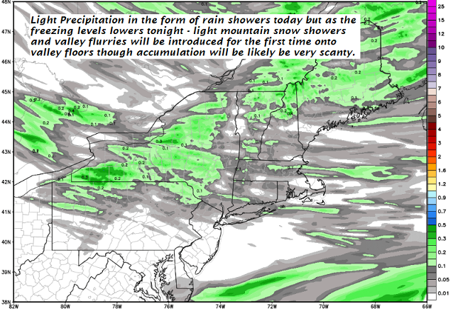
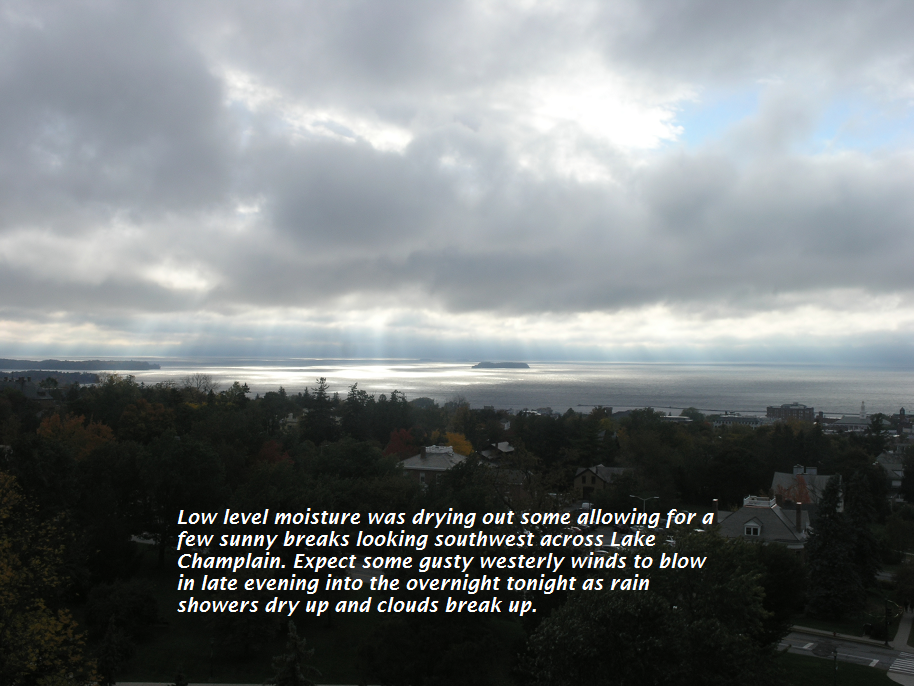
TODAY: Considerable cloudiness, maybe a break of sun. A high 40 to 45. West breeze 10 to 15 mph

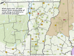
TONIGHT: Cloudy. Scattered rain showers mixed with wet snow flakes higher terrain mainly Northeast Kingdom. A low near 35. Light south winds.

TUESDAY: Gray skies and damp with occasional light rain showers. A high 45 to 50. Southeast breeze 10 to 15 mph.

Looking further ahead…

TUESDAY NIGHT: Lots of clouds with rain showers mixing with wet snow across the higher terrain. Minor accumulation. A low in the mid 30s.

Full Hunters Moon 12:45 PM Wednesday…

WEDNESDAY: Mainly gray. Occasional rain showers mixed with wet snow flakes in the higher terrain. A high around 40.

THURSDAY: Considerable cloudiness. Scattered flurries in the morning with a dusting to perhaps an inch mountain summits. A low around 30. A high around 35.

FRIDAY: Mostly sunny with below normal temperatures. A low in the 20s. A high in the mid to upper 30s.

Average lows ranging 30 to 35. Average highs 50 to 55.

RH/10-22-18[end]

Virus-free. www.avast.com

Updated Friday Night Forecast — October 19th, 2018

TONIGHT: Thickening clouds. A sprinkle or two possible toward daybreak. A low near 45. Southwest breeze 10 to 15 mph across the hills.

TOMORROW: Mostly cloudy. A couple sprinkles or light rain showers. Nar seasonal temperature.A high around 55. Southwest winds 10 to 20 mph.

SATURDAY NIGHT: Mostly cloudy. A few mountain sprinkles changing to snow flurries. Little more than a dusting…mainly high terrain. A low in the low 30s. Northwest winds 10 mph.

SUNDAY: Cloudy with scattered morning flurries. A dusting some valley floors to an inch Green Mountain summits. A high in the mid 30s. Northwest winds 10 to 20 mph.

Looking further ahead…

SUNDAY NIGHT: Mostly cloudy. A low 25 to 30.

MONDAY: Partly cloudy. Slight chance for a sprinkle, with a high 40 to 45.

TUESDAY: Lots of clouds. Scattered rain showers mixing with wet snow flakes at times valleys and minor coating higher summits. A low near 35. A high 40 to 45.

WEDNESDAY: Mainly gray. Chance for rain showers. A low around 35. A high in the mid 40s.

Average lows ranging through the 30s. Normal highs in the 50s

Virus-free. www.avast.com

Updated Friday morning Forecast — October 19th, 2018

TODAY: A beauty with tons of sunshine, breezy & milder. A high in the mid 50s. Southwest breeze 10 to 20 mph.

TONIGHT: Thickening clouds. A sprinkle or two possible overnight. A low near 45. Southwest breeze 10 to 15 mph across the hills.

SATURDAY: Mostly cloudy. A couple sprinkles or light showers. near seasonal temperature. A high around 55. Southwest winds 10 to 20 mph.

Looking further ahead…

SATURDAY NIGHT: Mostly cloudy. Scattered rain showers mixing wet snow. A dusting in spots. A low in the in the low 30s.

SUNDAY: Cloudy with scattered morning flurries. A dusting to an inch possible higher terrain. A high in the mid 30s.

MONDAY: Partly cloudy. Slight chance for a sprinkle. A low 25 to30, with a high 40 to 45.

TUESDAY: Lots of clouds. Scattered rain showers mixing with wet snow flakes at times A low near 35. A high 40 to 45.

WEDNESDAY: Mainly gray. Chance for rain showers. A low around 35. A high in the mid 40s.

Average lows ranging through the 30s. Normal highs in the 50s

RH/10-19-18[end]

Virus-free. www.avast.com

Updated Thursday Evening Forecast — October 18th, 2018

TONIGHT: Clear skies giving way to more clouds northern areas. Frosty lows upper 20s to near 32. Light southwest winds.

TOMORROW: Mostly sunny, breezy & milder. A high in the mid 50s. Southwest breeze 10 to 20 mph.

FRIDAY NIGHT: Variable clouds. A sprinkle or two possible overnight. A low 40 to 45. Southwest breeze 10 to 15 mph across the hills.

SATURDAY: Considerable cloudiness. Chance for a few passing light rain showers A high around 55. Southwest winds 10 to 20 mph.

Looking further ahead…

SATURDAY NIGHT: Scattered rain showers mixing wet snow. A dusting in spots. A low in the upper 20s to low 30s.

SUNDAY:. A high in the mid 30s.

MONDAY: Partly cloudy. A low around 25, with a high around 40..

TUESDAY: Lots of clouds. Scattered rain showers mixing with wet snow flakes at times A low near 35. A high 40 to 45.

WEDNESDAY: Mainly gray. Chance for rain showers. A low mid 30s to near 40. A high in the 40s.

Average lows ranging through the 30s. Normal highs in the 50s

RH/10-18-18[end]

Virus-free. www.avast.com

Updated Thursday morning Forecast — October 18th, 2018

TODAY: A few flurries especially near the central and northern Green Mountains early, then partly sunny, blustery and well below normal in temperature. A high in the mid to upper 30s. Northwest winds 10 to 25 mph lowering wind chills.

TONIGHT: Scattered clouds and cold. A low in the mid to upper 20s. Light southwest winds.

FRIDAY: Mostly sunny, breezy but milder. A high near 55. Southwest breeze 10 to 20 mph.

Looking further ahead…

FRIDAY NIGHT: Variable clouds, Maybe a few isolated mountain sprinkles. A low 40 to 45.

SATURDAY: Considerable cloudiness. Chance for a few sprinkles passing light rain showers mixing with wet snow flakes Saturday night. A high 50 to 55.

SUNDAY: Scattered mountain snow showers & valley flurries exiting toward mid day. A dusting valley floors up to an inch higher terrain. A low 32 to 35. A high 35 to 40.

MONDAY: Partly cloudy. A low in the 20s with a high 35 to 40.

TUESDAY: Mostly cloudy with scattered rain showers mixed with wet snow flakes early. Partly sunny central and southern areas. A low near 35. A high 45 to 50.

Average lows ranging through the 30s. Normal highs in the 50s

RH/10-18-18[end]

Virus-free. www.avast.com

Updated Wednesday Evening Forecast — October 17th, 2018

TONIGHT: Scattered rain showers changing to occasional flurries and mountain snow showers. Dusting some lower valleys and to 2” Green Mountain summits. A low mid 20s to near 30. Northwest winds 10 to 20 mph.

TOMORROW: A few flurries especially near the central and northern Green Mountains early, then partly sunny, blustery and well below normal in temperature. A high in the mid to upper 30s. Northwest winds 10 to 25 mph lowering wind chills.

THURSDAY NIGHT: Scattered clouds and cold. A low in the mid to upper 20s. Light southwest winds.

FRIDAY: Lots of sunshine and breezy at times. A high 50 to 55. Southwest breeze 10 to 20 mph.

Looking further ahead…

FRIDAY NIGHT: Variable clouds. A low around 40.

SATURDAY: Considerable cloudiness. Scattered light rain showers. A high 50 to 55.

SUNDAY: Mostly cloudy. Scattered mountain snow showers or flurries. Some minor accumulation. A low 30 to 35. A high in the upper 30s.

MONDAY: Partly cloudy. A low in the 20s with a high 35 to 40.

Average lows mid 30s to near 40. Normal highs in the mid to upper 50s

RH/10-1-18[end]

Virus-free. www.avast.com

Updated Wednesday morning forecast — October 17th, 2018

TODAY: Mostly cloudy. Scattered light rain showers. A high in the upper 40s to around 50. West breeze 10 to 20 mph.

TONIGHT: Scattered rain showers changing to occasional flurries and mountain snow showers. dusting lower valleys up to 2” Green Mountain summits. A low in the mid 20s to near 30. Northwest winds 10 to 20 mph.

THURSDAY: A few flurries especially near the northern Green Mountains early, then partly sunny, blustery and well below normal in temperature. A high in the mid to upper 30s. Northwest winds 10 to 25 mph lowering wind chills.

Looking further ahead…

THURSDAY NIGHT: Scattered clouds and cold. A low in the mid 20s.

FRIDAY: Lots of sunshine. A high 50 to 55.

SATURDAY: Considerable cloudiness. Scattered light rain showers. A low around 40. A high 50 to 55.

SUNDAY: Mostly cloudy. Scattered mountain snow showers or flurries. Some minor accumulation. A low 30 to 35. A high in the upper 30s.

MONDAY: Partly cloudy. A low in the 20s with a high 35 to 40.

Average lows mid 30s to near 40. Normal highs in the mid to upper 50s

RH/10-1-18[end]

Virus-free. www.avast.com

Updated Tuesday Evening Forecast — October 16th, 2018

TONIGHT: Mostly clear this evening giving way to more clouds overnight. A low near 40. Light south winds.

TOMORROW: Mostly cloudy. Scattered light rain showers. A high in the upper 40s to around 50. West breeze 10 to 20 mph.

WEDNESDAY NIGHT: Scattered rain showers changing to occasional flurries and mountain snow showers. Some minor accumulation across the mountains… with a dusting down to valley floors. A low around 30. Northwest winds 10 to 15 mph .

THURSDAY: A couple morning flurries, then partly sunny and blustery and cold. A high mid to upper 30s. Northwest winds 10 to 25 mph with higher gusts in the hills.

Looking further ahead…

THURSDAY NIGHT: Scattered clouds and cold. A low in the mid 20s.

FRIDAY: Partly to mostly sunny. A high 50 to 55.

SATURDAY: Cloudy. Scattered light rain showers. A low around 40. A high 50 to 55.

SUNDAY: Partly cloudy. Scattered mountain flurries. A low 32 to 35. A high near 40.

Average lows mid 30s to near 40. Normal highs in the mid to upper 50s

RH/10-16-18[end]

Virus-free. www.avast.com

Updated Tuesday morning forecast — October 16th, 2018

TODAY: Partly sunny. A high upper 40s to near 50. Blustery west to southwesterly winds 10 to 25 mph gradually diminishing.

TONIGHT: Mostly clear this evening giving way to more clouds overnight. A low near 40. Light south winds.

WEDNESDAY: Mostly cloudy. Chance for light rain showers. A high in the upper 40s to around 50. West breeze 10 to 20 mph.

Looking further ahead…

WEDNESDAY NIGHT: Rain showers transitioning to occasional light flurries. Some minor accumulations higher terrain… with dusting grassy surfaces lower terrain. A low around 30.

THURSDAY: A couple morning flurries then mixed clouds and sun & blustery. Well below normal in temperature. A high in the mid to upper 30s.

FRIDAY: Partly to mostly sunny. A “freezing morning low” mid 20s to low 30s. A high 50 to 55.

SATURDAY: Considerable cloudiness with a chance for rain showers. A low around 40. A high 50 to 55.

SUNDAY: Mixed clouds and sun with a few mountain flurries mixed with rain valley floors. A low around 32 degrees. A high in the low 40s.

Average lows mid 30s to near 40. Normal highs in the mid to upper 50s

RH/10-16-18[end]

Virus-free. www.avast.com

Updated Monday Evening Forecast — October 15th, 2018

TONIGHT: Scattered light rain showers tapering off this evening. Becoming partly cloudy and blustery. A low in the mid to upper 30s. Winds becoming westerly picking up to 10 to 25 mph with higher gusts across the hills.

TOMORROW: Morning sunshine mixing with a few more clouds in the afternoon. A high upper 40s to near 50. Blustery west to northwest winds 10 to 20 mph.

TUESDAY NIGHT: Mostly clear early, then clouding up. A few light rain showers…mixed with wet snow flakes Greens Mountain summits. A low upper 30s to about 40. Light south winds.

WEDNESDAY: Mostly cloudy. Chance for a light rain showers. A high 45 to 50. West breeze 10 to 20 mph.

Looking further ahead…

WEDNESDAY NIGHT: Rain showers transitioning to occasional flurries. Some minor accumulations higher terrain with dusting grassy surfaces valley floors. A low around 30

THURSDAY: A couple morning flurries then partly cloudy & blustery. A high in the mid to upper 30s.

FRIDAY: Maybe a few mixed rain or snow showers early, then partial clearing. A low around 35. A high in the mid 50s.

Average lows mid 30s to near 40. Normal highs in the mid to upper 50s

RH/10-15-18[end]

Virus-free. www.avast.com