Updated Thursday Evening Forecast — February 7th, 2019

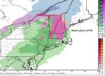
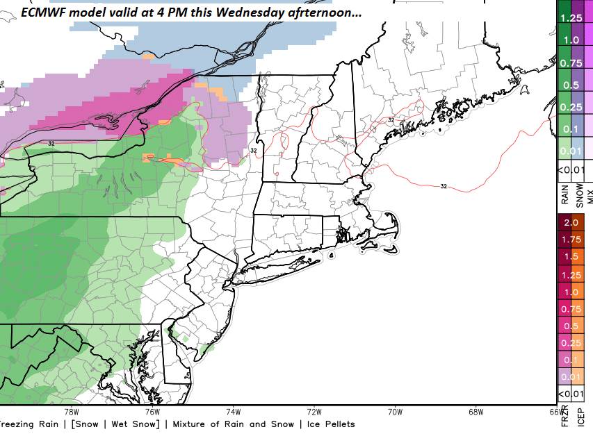
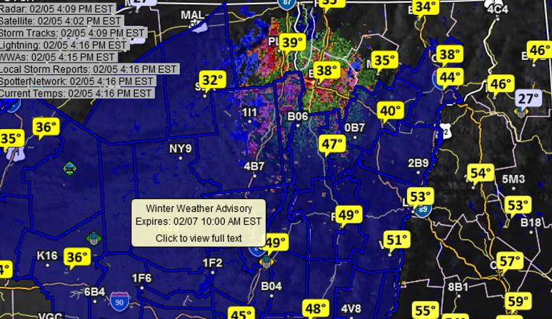
Winter Weather Advisory Green Mountains east…7 PM this evening through 7 AM Friday…

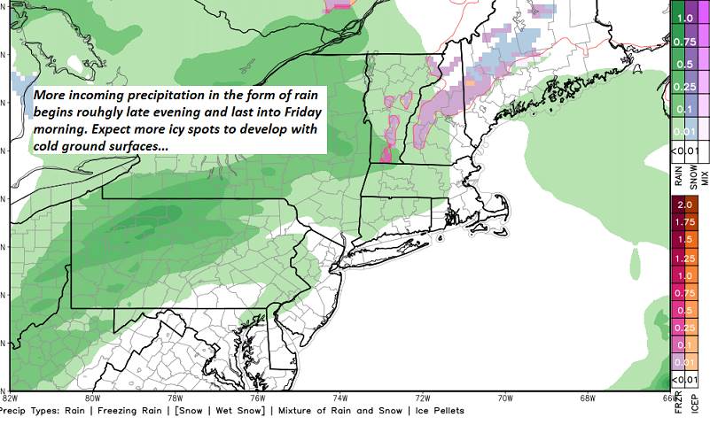
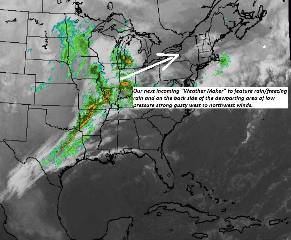
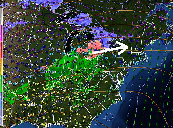
TONIGHT: Cloudy. Light intermittent rain, pockets of freezing rain developing toward midnight east of the Green Mountains. Expect slick travel and some minor glazing. A late evening low 30 to 35, then temperatures gradually rising overnight. Southeast winds 10 to 20 mph.

Wind Advisory Friday through 10 AM Saturday…

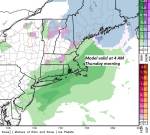
TOMORROW: Morning rain with slick spots for untreated roads ending by noon with intervals of sunshine. More clouds with a few mountain flurries later in the afternoon. A high 40 to 45…falling into the mid to upper 20s in the afternoon. Becoming blustery to windy. Southwest winds shifting to northwesterly 10 to 25 mph with higher gusts.

FRIDAY NIGHT: Partly cloudy & colder. Blustery to windy. A few stray flurries. A low 5 to 15 above. Gusty west to northwest winds 10 to 25 mph with higher gusts & lowered wind chills.

SATURDAY: Sunny, but blustery to windy with lowered wind chills. Much colder. Temperatures 5 to 15 above. West to northwest winds 10 to 25 mph with higher gusts mainly in the morning lowering wind chills.

Looking further ahead…

SATURDAY NIGHT: Clear skies. A low 5 above to 5 below.

SUNDAY: Mostly sunny. A high mid teens to low 20s.

MONDAY: Lots of sunshine but cold. A low 5 above to 10 below. A high low to mid teens.

TUESDAY: Partial morning sun, then thickening clouds. A low zero to 10 below. A high in the 20s.

WEDNESDAY: Chance for light accumulating snow in the morning tapering to scattered snow showers in the afternoon.

Average lows single digits. Average highs in the 20s.

RH/2-7-19[end]

Updated Thursday morning Forecast — February 7th, 2019

TODAY: Cloudy and gray with areas of dense fog this morning. A high upper 30s to around 40. Southeast winds 10 to 15 mph.

TONIGHT: Overcast. Rain developing late this evening…with pockets of freezing rain east of Green Mountains. Expect slick travel. An early low 32 to 35 then temperatures gradually rising overnight. Southeast winds 10 to 20 mph.

FRIDAY: Mainly cloudy and changeable. Rain with pockets of freezing rain early exiting in the morning. Chance for a few flurries later in the afternoon. A high 40 to 45 in the morning…falling into the mid to upper 20s in the afternoon. Becoming blustery to windy. Southwest winds shifting to northwesterly 10 to 25 mph with higher gusts.

Looking further ahead…

FRIDAY NIGHT: Partly to mostly cloudy & blustery to windy. Scattered flurries. Little accumulation. A low 5 to 15 above. Gusty west to northwest winds with lowered wind chills.

SATURDAY: Lots of sunshine. Much colder. Blustery to windy. Temperatures 5 to 15 above. Gusty west to northwest winds with lowered wind chills.

SUNDAY: Mostly sunny after a frigid start. A low 5 above to 5 below. A high mid teens to low 20s.

MONDAY: Sunshine filtered through high clouds. A low 5 above to 10below. A high low to mid teens.

TUESDAY: Partial morning sun, then thickening clouds. A low zero to 10 below. A high in the 20s.

Average lows single digits. Average highs in the 20s.

RH/2-7-19[end]

Updated Wednesday Evening Forecast — February 6th, 2019

Winter Weather Advisory in effect Tonight into Thursday morning…

TONIGHT: Overcast. Mixed precipitation primarily freezing rain. Glazing tenth up to an ¼ inch in some spots. Expect treacherous travel. An early low 25 to 32. Southeast winds 10 mph.

TOMORROW: Gray…spotty freezing rain early with poor travelexiting as sprinkles. A high 35 to 40. Southeast winds 10 to 15 mph.

THURSDAY NIGHT: Increasing clouds. Rain with pockets of freezing rain becoming likely overnight. Watch for slick spots. An early low 30 to 32. Southeast winds 10 to 20 mph.

FRIDAY: Mainly cloudy and changeable. Rain with pockets of freezing rain early exiting in the morning. Chance for a few flurries later in the afternoon. A high 40 to 45. Blustery to windy. Southwest winds shifting to northwest 10 to 25 mph.

Looking further ahead…

FRIDAY NIGHT: Partly cloudy & blustery to windy. Scattered flurries. Little accumulation. A low ranging through the teens.

SATURDAY: Lots of sunshine. Much colder. Blustery to windy. Temperatures falling into the mid single digits to low teens. Gusty west to northwest winds with lowered wind chills.

SUNDAY: Mostly sunny after a frigid start. A low 5 above to 5 below. A high mid teens to low 20s.

MONDAY: Sunshine filtered through high clouds. A low 5 above to 5 below. A high in the teens.

Average lows single digits. Average highs in the 20s.

RH/2-6-19[end]

Updated Wednesday morning Forecast — February 6th, 2019

TODAY: Brief morning sun, then clouding up. A rising chance for spotty wet snow and sleet late toward Rutland. Back to near seasonable temperatures. A high upper 20s to near 32 degrees. Light northeast winds.

Winter Weather Advisory goes into effect 4 PM Wednesday… into Thursday morning.

TONIGHT: Overcast. Mixed precipitation primarily freezing rain. Glazing tenth up to an ¼ inch in some spots. Expect treacherous travel. A low mid 20s to low 30s. Southeast winds 10 mph.

THURSDAY: Gray…spotty freezing rain early with poor travel earlyexiting as sprinkles. A high 35 to 40. Southeast winds 10 to 20 mph.

Looking further ahead…

THURSDAY NIGHT: Fair and dry early, then clouding up. Rain with pockets of freezing rain becoming likely overnight. A low 30 to 35.

FRIDAY: Mainly cloudy and changeable. Good chance for freezing rain early in the morning changing to rain before tapering to rain showers with a few wet snow flakes late. Turning blustery to windy late afternoon into Friday night. A high in the 40s.

SATURDAY: Clouds give way to increasing sunshine. Much colder Blustery to windy. A low in the single digits. A high in the low to mid teens. Gusty west to northwest winds.

SUNDAY: Mostly sunny after a frigid start. A low 5 above to 5 below. A high upper teens to mid 20s.

Average lows 5 to 15 above. Average highs in the 20s.

RH/2-6-19[end]

Updated Tuesday Evening Forecast — February 5th, 2019

TONIGHT: Evening clouds then partial clearing overnight. Much colder. A low upper single digits to mid teens. Northwest winds 10 mph.

TOMORROW: Sunshine, giving way to thickening afternoon clouds. A rising chance for spotty mixed precipitation arriving late toward Rutland. Back to near seasonable temperatures. A high mid 20s to near 32 degrees. Light northeast winds.

Winter Weather Advisory goes into effect 4 PM Wednesday… into Thursday morning.

WEDNESDAY NIGHT: Overcast. Mixed precipitation primarily freezing rain. Glazing up to an 1/4inch with more possible toward Windsor county. Expect treacherous travel. A low 25 to 30. Southeast winds 10 mph.

THURSDAY: Gray…periods of mixed precipitation with poor travel earlyexiting as sprinkles early afternoon. A high 35 to 40. Southeast winds 10 to 20 mph.

Looking further ahead…

THURSDAY NIGHT: Fair and dry early, then clouding up. Rain with pockets of freezing rain becoming likely overnight. A low around 30.

FRIDAY: Mainly cloudy and changeable. Good chance for freezing rain early in the morning changing to rain before tapering to rain showers with a few wet snow flakes late. Turning blustery to windy late afternoon into Friday night. A high in the 40s.

SATURDAY: Clouds give way to increasing sunshine. Much colder Blustery to windy. A low in the single digits. A high in the low to mid teens. Gusty west to northwest winds.

SUNDAY: Mostly sunny after a frigid start. A low 5 above to 5 below. A high upper teens to mid 20s.

Average lows single digits. Average highs in the 20s.

RH/2-5-19[end]

Updated Tuesday Morning Forecast — February 5th, 2019

TODAY: Scattered light rain showers exiting to a few leftover sprinkles northern areas. Otherwiselots of clouds with as few breaks of sun. A high mid 40s to low 50s, then sharply colder later in the day. Gusty west to northwest winds developing 10 to 25 mph.

TONIGHT: Evening clouds then partial clearing overnight. Much colder. A low upper single digits to mid teens. Northwest winds 10 mph.

WEDNESDAY: Sunshine, giving way to thickening afternoon clouds. Back to near seasonable temperatures. A high mid 20s to low 30s. Light north winds.

Looking further ahead…

WEDNESDAY NIGHT: Overcast. Periods of freezing rain developing in the evening. Some glazing likely with treacherous travel. A low 25 to 30.

THURSDAY: Gray…periods of mixed precipitation with poor travel in the morningexiting as sprinkles early afternoon. A high mid 30s to low 40s.

FRIDAY: Mainly cloudy and changeable. Good chance for freezing rain early in the morning changing to rain before tapering to rain showers with a few wet snow flakes late. Turning blustery to windy late afternoon into the night. A morning low 32 to 35, with a high mid 40s to near 50.

SATURDAY: Clouds give way to increasing sunshine. Much colder Blustery to windy. A low in the single digits. A high in the low to mid teens. Gusty west to northwest winds.

SUNDAY: Mostly sunny after a frigid start. A low 5 above to 5 below. A high upper teens to mid 20s.

Average lows single digits. Average highs in the 20s.

RH/2-5-19[end]

Updated Monday Night Forecast — February 4th, 2019

TONIGHT: Partly cloudy this evening, then clouding up. Periods of light rain developing overnight. Possible icy spots on back roads. A low mid 30s to low 40s. South winds 10 mph.

TOMORROW: Scattered light rain showers early, otherwise considerable cloudiness with a sprinkle northern areas. An early high mid 40s to low 50s, then colder in the late afternoon. Gusty west to northwest winds developing 10 to 25 mph.

TUESDAY NIGHT: Evening clouds then partial clearing overnight. Much colder. A low upper single digits to mid teens. Northwest winds 10 mph.

WEDNESDAY: Sunshine, giving way to thickening afternoon clouds. Back to near seasonable temperatures. A high mid 20s to low 30s. North winds.

Looking further ahead…

WEDNESDAY NIGHT: Overcast. Periods of freezing rain developing in the evening. Some glazing likely. A low 25 to 30.

THURSDAY: Gray…periods of mixed precipitation with poor travel in the morningexiting as rain showers early afternoon. A high mid 30s to low 40s.

FRIDAY: Mainly cloudy. Chance for periods of rain…with spotty freezing rain in the morning. Widely scattered sprinkles exiting in the afternoon. Again very mild but turning blustery in the afternoon. A morning low 32 to 35, with a high mid 40s to near 50.

SATURDAY: Clouds then increasingly sunny. Much colder. A low in the single digits. A high in the low to mid teens.

Average lows single digits. Average highs in the 20s.

RH/2-4-19[end]

Updated Monday Morning Forecast — February 4th, 2019

TODAY: Scattered light rain showers or sprinkles Barre-Montpelier area north through late-morning…gradually drying up. Watch for icy slick spots northern areas. Otherwise cloudy northerner areas with intervals of sun toward Rutland. A high in the 40s to near 50 southern areas. Light southwest winds.

TONIGHT: Fair early, then clouding up. Periods of rain likely developing overnight. Watch for icy spots on back roads. A low mid 30s to low 40s. South winds 10 to 15 mph.

TUESDAY: Mainly gray. Light rain showers especially in the morning and mild with melting snow. A high 40 to 45 northern areas other 40s to near 50 southern areas. Gusty west winds developing 10 to 25 mph.

Looking further ahead…

TUESDAY NIGHT: Partial clearing and much colder. A low in the single digits.

WEDNESDAY: Sunshine, giving way to high cloudiness thickening up late. A rising chance for rain or freezing rain later toward evening. Back to near seasonable temperatures. A high mid 20s to low 30s.

THURSDAY: Gray…Chance for periods of freezing rain in the morning exiting before noon with improving conditions. Treacherous travel in the morning. A low 25 to 30. A high mid 30s to low 40s.

FRIDAY: Gray. Chance for periods of rain…possibly icy spots in the morning. A morning low 35 to 40, an early high near 40 then falling into the 20s.

Average lows single digits. Average highs in the 20s.

RH/2-4-19[end]

Updated Friday Evening Forecast — February 1, 2019

TONIGHT: Clear in the evening, then increasing clouds overnight. A low zero 10 below. Light southwest winds.

SATURDAY: Lots of clouds north with a good chance for light accumulating snow showers late morning on…northern areas dusting to an inch. Sun mixed with clouds southern areas. A high upper teens to mid 20s. Southwest winds 10 mph.

SATURDAY NIGHT: Becoming mostly clear. A low in the single digits. Light northwest winds.

SUNDAY: Partial morning sunshine, turning gray in the afternoon. Chance for a late day flurries. A high upper 20s to low 30s. Light south winds.

Looking further Ahead…

SUPER BOWL SUNDAY NIGHT: Cloudy with scattered mixed precipitation with possible slick travel northern areas. Partly cloudy elsewhere. . A low around 32 degrees.

MONDAY: Scattered light rain showers barre-Montpelier area north . Mixed clouds and sun and much milder southern areas. A high 40 to 45.

TUESDAY: Gray skies. Chance light rain showers mixing with wet snow flakes late. Mild with melting snow. A low mid to upper 30s. A high 45 to 50.

WEDNESDAY: Mostly sunny. Back to near seasonable temperatures. A low in the single digits. A high mid teens to low 20s

THURSDAY: Cloudy. Chance for a wintry mix in the afternoon with poor travel. A low zero to 5 below. A high 25 to 30.

Average lows single digits. Average highs in the 20s.

RH/2-1-19[end]

Updated Friday morning forecast — February 1st, 2019

Wind Chill Advisory expires late this morning…

TODAY: Sunny and cold. A high 10 to 15 above. West winds 10 mph.

TONIGHT: Clear in the evening, then increasing clouds overnight. A low zero 10 below. Light southwest winds.

SATURDAY: Lots of clouds north with a good chance for light accumulating late morning on…northern areas dusting to an inch. Sun mixed with clouds southern areas. A high 20 to 25. South to southwest winds 10 to 15 mph.

Looking further Ahead…

SATURDAY NIGHT: Becoming mostly clear. A low 5 above to 10 below.

SUPER BOWL SUNDAY: Partial morning sunshine, turning gray in the afternoon. Chance for a late day flurries. A high pushing toward 32.

MONDAY: Chance for a wintery mix with slick travel across northern areas in the morning. Mixed clouds and sun and much milder southern areas. A low near 32 degrees. A high 40 to 45.

TUESDAY: Gray skies. Chance light rain showers mixing with wet snow flakes late. Mild with melting snow. A low mid to upper 30s. A high 45 to 50.

WEDNESDAY: Mostly sunny. Back to near seasonable temperatures. A low in the single digits. A high in the 20s.

THURSDAY: Cloudy. Chance for a wintry mix in the afternoon with poor travel. A low around 10. A high near 30.

Average lows single digits. Average highs in the 20s.

RH/2-1-19[end]