Updated Thursday Morning Weather — November 7th, 2019

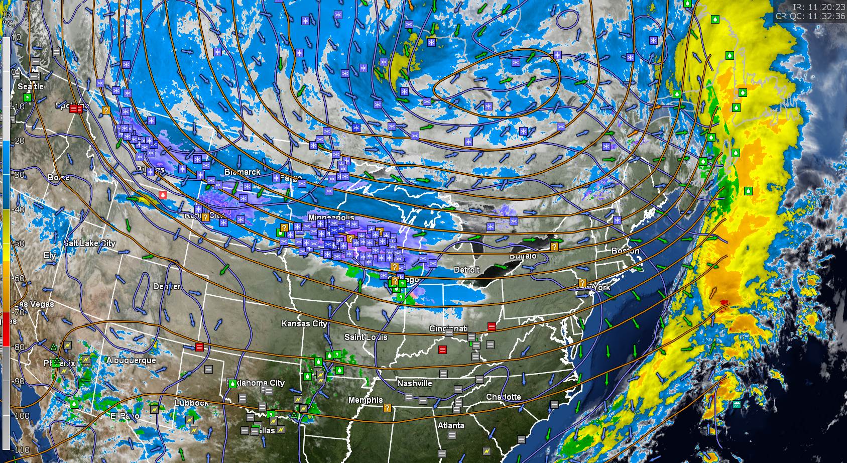
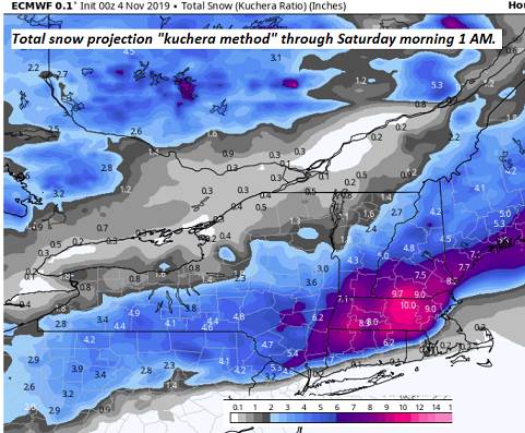
TODAY: Gray skies. Light snow showers mixed with rain some valley floors northern areas this morning. Light snow will continue to overspread the region from north to south this afternoon. Little to no accumulation valleys with a dusting to 2 inches above 2000 ft. A high upper 30s to lower 40s. Light west to southwest winds.

TONIGHT: Periods of accumulating light snow with slick travel this evening…tapering off overnight with partial clearing. Total snow accumulation – a dusting to locally 3” A low in the mid 20s. Light northwest winds.

FRIDAY: Partly to mostly cloudy and blustery. Scattered mountain snow showers or flurries. Less than an inch additional accumulation. A high around 30. Northwest winds 10 to 20 mph.

Looking further ahead…

FRIDAY NIGHT: A couple leftover flurries, then clearing. A low upper teens to around 20.

SATURDAY: More sun than clouds. Rather chilly. A high in the low 30s.

SUNDAY: Morning sun then mostly cloudy. Occasional mountain flurries and valley sprinkles. A low near 25. A high 40 to 45.

MONDAY: Clouds with intervals of sunshine. Chance for a mountain flurry/valley sprinkle. A low 20 to 25. A high near 40.

Average lows upper 20s to low 30s. Average highs mid 40s to around 50.

RH/11-7-19[end]

Updated Wednesday Night Forecast — November 6th, 2019

TONIGHT: Some high cloudiness this evening…thickening up overnight. A low around 32. Light southwest winds.

TOMORROW: Gray skies. Intermittent light snow showers northern areas…mixed with rain lower valley floors in the morning. Light snow overspreading the region late morning into the afternoon. Dusting to 2 inches…especially higher terrain. A high upper 30s to lower 40s. Light west to southwest winds.

THURSDAY NIGHT: Overcast. Periods of accumulating snow with slick travel in the evening…tapering scattered snow showers or flurries overnight. A low 20 to 25. Light northwest winds.

FRIDAY: Partly to mostly cloudy and blustery. Scattered mountain snow showers and valley flurries. Accumulation dusting to 2” valleys…more in elevated terrain. A high around 30. Northwest winds 10 to 20 mph.

Looking further ahead…

FRIDAY NIGHT: Chance for lingering early evening flurries, then clearing northwest to southeast. A low upper teens to around 20.

SATURDAY: More sun than clouds. Rather chilly. A high in the low 30s.

SUNDAY: Morning sun then mostly cloudy. Occasional mountain flurries and valley sprinkles. A low near 25. A high 40 to 45.

MONDAY: Clouds with intervals of sunshine. Chance for a mountain flurry/valley sprinkle. A low 20 to 25. A high near 40.

Average lows upper 20s to low 30s. Average highs mid 40s to around 50.

RH/11-6-19[end]

Updated Wednesday morning Forecast — November 6th, 2019

TODAY: A few wet snowflakes this morning across northern areas. Otherwise, periods of sunshine. Blustery. A high 40 to 45. West breeze 10 to 25 mph and gusty.

TONIGHT: Mostly clear this evening, then clouding up with a rising chance for flurries northern areas. Watch for slick spots. A low about 30. Light south winds.

THURSDAY: Mostly cloudy. Intermittent light wet snow showers, mixed with rain lower valley floors – slick travel across elevated terrain. A high upper 30s to around 40. Light south winds.

Looking further ahead…

THURSDAY NIGHT: Overcast. Periods of accumulating snow with slick travel. A low around 25.

FRIDAY: Mostly cloudy and blustery. Occasional snow showers and valley flurries. Total snow accumulation 1 to locally 4” with up to 6”Green Mountain summits and elevated terrain Northeast Kingdom highlands. A high 30 to 35.

SATURDAY: Partly sunny but colder. A low in the mid teens. A high near 30.

SUNDAY: Morning sun then partly to mostly cloudy. Isolated mountain flurries & valley sprinkles. A low 20 to 25. A high near 40.

MONDAY: Clouds with intervals of sunshine. Chance for a mountain flurry valley sprinkle. A low in the mid to upper teens. A high 35 to 40.

Average lows upper 20s to low 30s. Average highs mid 40s to around 50.

RH/11-6-19[end]

Updated Tuesday Evening Forecast — November 5th, 2019

TONIGHT: An evening sprinkle exiting then partial clearing developing. A low near 32. Light west winds.

TOMORROW: Clouds mixed with intervals of sun. A few wet snowflakes or rain drops possible near the Quebec border. A high 40 to 45. West breeze 10 to 20 mph.

WEDNESDAY NIGHT: Partly cloudy. Maybe a few flurries. Watch for slick spots. A low in the low 30s. Light south winds.

THURSDAY: Mostly cloudy. Intermittent light wet snow showers, mixed with rain lower valley floors – slick travel across elevated terrain. A high mid to upper 30s. Light south winds.

Looking further ahead…

THURSDAY NIGHT: Overcast. Periods of accumulating snow. A few to several inches likely with slick travel. A low around 25.

FRIDAY: Mostly cloudy and blustery. Occasional snow showers and valley flurries. Minor additional accumulation. A high around 32.

SATURDAY: Partly sunny but colder. A low in the mid teens. A high near 30.

SUNDAY: Morning sun gives way to thickening clouds. Scattered snow showers or flurries. A low in the upper teens. A high 35 to 40.

Average lows upper 20s to low 30s. Average highs mid 40s to around 50.

RH/11-5-19[end]

Updated Tuesday Morning Forecast — November 5th 2019

TODAY: Scattered light sprinkles or rain showers. Otherwise, gray with a few late day breaks of sunshine. A high upper 40s to low 50s. South breeze 10 to 15 mph.

TONIGHT: An evening sprinkle exiting then partial clearing developing. A low around 30. Light west winds.

WEDNESDAY: Morning sun then increasing clouds in the afternoon. A high 40 to 45. West breeze 10 to 15 mph.

Looking further ahead…

WEDNESDAY NIGHT: Mostly cloudy. Slight chance for light snow showers or flurries northern areas toward daybreak. Watch for slick spots. A low around 30.

THURSDAY: Mostly cloudy. Chance for intermittent light wet snow showers, mixed with rain showers lower valley floors – slick travel across elevated terrain. A high mid to upper 30s.

FRIDAY: Overcast. Periods of accumulating snow with slippery travel. Light to moderate snow accumulation with perhaps half a foot across elevated terrain. Blustery at times. A low around 25. A high around 32.

SATURDAY: Partly sunny but colder. A low in the teens. A high mid 20s to near 30.

SUNDAY: Morning sun gives way to thickening clouds. A low in the teens. A high around 35.

Average lows upper 20s to low 30s. Average highs mid 40s to around 50.

RH/11-5-19[end]

Updated Monday Night Forecast — November 4th, 2019

TONIGHT: Mainly cloudy. Chance for a few light showers toward daybreak. A low in the mid to upper 30s. South winds 10 mph.

TOMORROW: Scattered light sprinkles or rain showers. Otherwise, gray with a few late day breaks of sunshine. A high upper 40s to low 50s. South breeze 10 to 15 mph.

TUESDAY NIGHT: An evening sprinkle exiting then partial clearing developing. A low around 30. Light west winds.

WEDNESDAY: Morning sun then increasing clouds in the afternoon. A high 40 to 45. West breeze 10 to 15 mph.

Looking further ahead…

WEDNESDAY NIGHT: Mostly cloudy. Slight chance for light snow showers or flurries northern areas toward daybreak. Watch for slick spots. A low around 30.

THURSDAY: Mostly cloudy. Chance for wet snow showers, mixed with rain showers valley floors – Possible slick travel higher terrain. A high in the upper 30s to near 40.

FRIDAY: Overcast. Periods of light accumulating snow slushy travel. 1 to locally 4”inches possible northern areas with more possible southern areas. A low around 25. A high around 32.

Average lows upper 20s to low 30s. Average highs mid 40s to around 50.

RH/11-4-19[end]

Updated Monday Morning Forecast — November 4th, 2019

TODAY: Mixed clouds and sun through early afternoon, then clouding up. A high around 45. Light south winds.

TONIGHT: Mainly cloudy. Chance for a few light showers toward daybreak northern areas. A low in the mid to upper 30s. South winds 10 mph.

TUESDAY: Rain showers likely. Otherwise, gray with a few late day breaks of sunshine. A high upper 40s to low 50s. South winds 10 to 15 mph.

Looking further ahead…

TUESDAY NIGHT: Scattered evening rain showers. A low around 30.

WEDNESDAY: Mostly sunny. A high in the low to mid 40s.

THURSDAY: Mostly cloudy. Chance for wet snow and rain showers mainly northern areas in the morning – watch for possible slick travel higher terrain. A low around 30. A high in the upper 30s to near 40.

FRIDAY: Overcast. Periods of light accumulating snow. A few inches possible especially southern areas. A low around 25. A high around 32.

Average lows upper 20s to low 30s. Average highs mid 40s to around 50.

RH/11-4-19[end]

Updated Friday Evening Forecast — November 1st, 2019

TONIGHT: Becoming mostly clear & less blustery. A low in the upper 20s to around 30. West winds 10 to 20 mph this evening gradually diminishing.

TOMORROW: Partly to mostly sunny but colder. A high mid to upper 40s. Light south winds.

Set Clocks back 1-hour to EST

SATURDAY NIGHT: Mostly clear with a few clouds overnight. Maybe a sprinkle or wet snowflake far north. A low near 30. Light south winds.

SUNDAY: Mixed sun and clouds. Blustery. Scattered rain showers, mixed with wet snow flakes or graupel. A high mid 40s. Southwest breeze 10 to 20 mph.

Looking further ahead…

SUNDAY NIGHT: Scattered clouds. A low in the mid to upper 20s.

MONDAY: Partly to mostly sunny. A high mid to upper 40s.

TUESDAY: Morning sun gives way to a few more clouds. Scattered light rain showers in the afternoon. A low near 35. A high in the low to mid 50s.

WEDNESDAY: Mostly sunny. A low in the upper 20s. A high near 45.

Average lows upper 20s to mid-30s. Average highs upper 40s to mid-50s.

RH/11-1-19[end]

Updated Thursday Evening forecast — October 31st Hallows Eve 2019

Flood Watch through Tomorrow evening…Wind Advisory tonight thru late Friday

TONIGHT: Overcast. Periods of rain, moderate to heavy at times and breezy to windy. Temperatures in the low 60s this evening…falling into the upper 40s by daybreak. South winds 10 to 20 mph with higher gusts across the hills shifting to southwesterly 15 to 30 mph with higher gusts.

TOMORROW: Blustery to windy. Showers exiting before mid-morning with a few breaks of sun. Colder. Temperatures holding around 45. Strong gusty southwesterly winds 10 to 30 mph with gusts 40 to locally 55 mph especially high terrain.

FRIDAY NIGHT: Becoming mostly clear & less blustery. A low in the upper 20s to around 30. West winds 10 to 20 mph diminishing overnight.

SATURDAY: Partly to mostly sunny but colder. A high mid to upper 40s. Light south to southwest winds.

Looking further ahead…

Set Clocks back 1-hour to EST

SATURDAY NIGHT: Mostly clear with a few clouds overnight. A low near 30.

SUNDAY: Mixed sun and clouds. Isolated rain shower, mixed with wet snow flake or graupel. A high mid to upper 40s.

MONDAY: Partly to mostly sunny. A low 25 to 30. A high mid to upper 40s.

TUESDAY: Morning sun then lots of clouds. Scattered sprinkles or rain showers in the afternoon. A low 32 to 35. A high around 50.

Average lows upper 20s to mid-30s. Average highs upper 40s to mid-50s.

RH/10-31-19[end]

Updated Thursday morning forecast — October 31st, 2019

Flood Watch this Afternoon through Friday Evening…Wind Advisory late today thru late Friday

TODAY: Overcast. Intermittent light rain moderate at times late. Milder. A high near 65. South to southeast winds 10 to 15 mph.

HALLOWS EVE: Rain…possibly moderate at times. Breezy to windy especially higher terrain. Temperatures near 60 trick or treater’s Thursday evening.

THURSDAY OVERNIGHT: Overcast. Periods of rain, moderate to heavy at times and breezy to windy in the higher terrain. Temperatures falling into the upper 40s. South winds 10 to 20 mph with higher gusts across the hills.

FRIDAY: Scattered leftover showers exiting. Blustery to windy withintervals of sun in the afternoon. Temperatures holding around 45. Strong gusty southwesterly winds 10 to 30 mph with gusts 40 to 55 mph especially high terrain.

Looking further ahead…

FRIDAY NIGHT: Becoming mostly clear & turning much less blustery. A low in the upper 20s to around 30.

SATURDAY: Partly to mostly sunny but colder. A high mid-40s.

Time change fall back 1-hour to EST gain extra sleep.

SUNDAY: Morning sun, then partly cloudy. Widely scattered rain showers, maybe a wet snow flake or graupel. A low near 30. A high near 45.

MONDAY: Mostly sunny. A low 25 to 30. A high around 45.

TUESDAY: Morning sun then lots of clouds. Chance for rain showers. A low around 32. A high in the low 50s.

Average lows upper 20s to mid-30s. Average highs upper 40s to mid-50s.

RH/10-31-19[end]