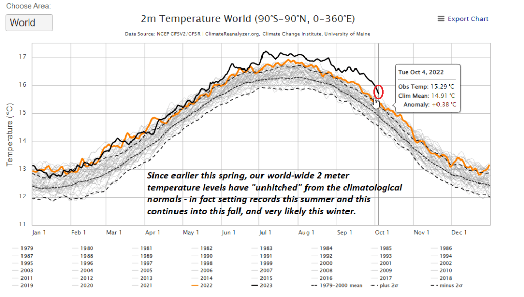
Unprecedented warmth worldwide continues as climatological normals shown in the numerous years below. This was speculated to continue as we are in a “new early era” of the anthropocene.


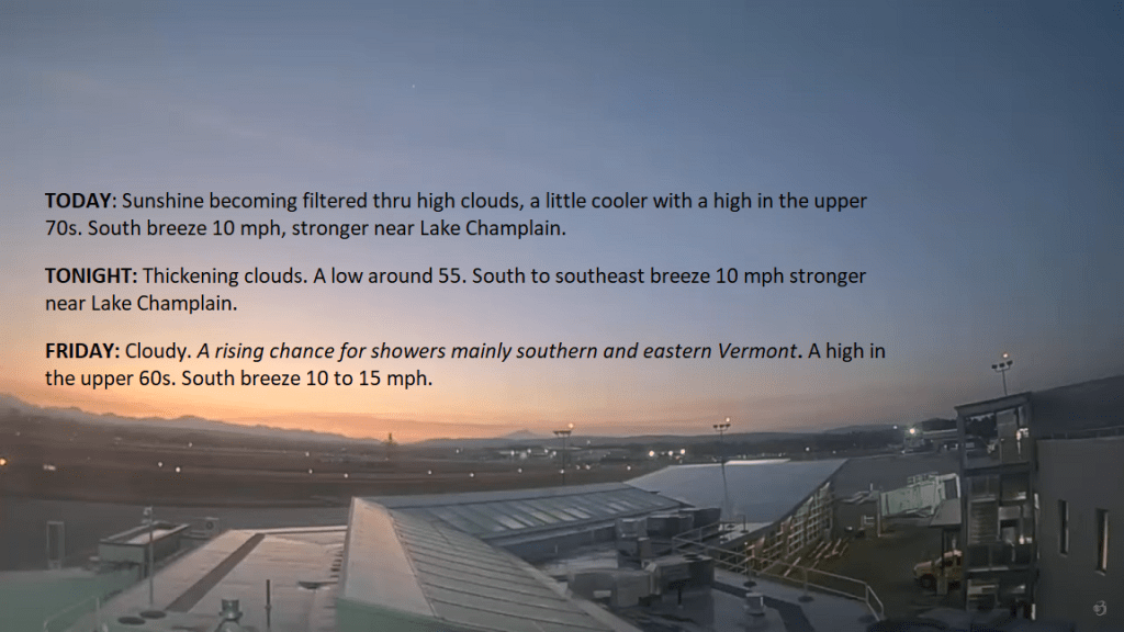
TODAY: Sunshine becoming filtered through high clouds, a little cooler with a high in the upper 70s. South breeze 10 mph, stronger near Lake Champlain.
TONIGHT: Thickening clouds.A low around 55. South to southeast breeze 10 mph stronger near Lake Champlain.
FRIDAY: Cloudy.A rising chance for showers mainly in southern and eastern Vermont. A high in the upper 60s. South breeze 10 to 15 mph.
Looking further ahead
FRIDAY NIGHT: Cloudy. Showers becoming likely across western areas. A low around 60.
SATURDAY: Overcast. Showers are likely, some moderate at times in western areas, with a few rumbles of thunder possible. Breezy. A high in the mid-60s.
SUNDAY: Partly cloudy, unsettled, and becoming blustery, with scattered showers.A low in the mid-40s. A high in the upper 50s.
MONDAY: More sun than clouds. Chance for mountain sprinkles or brief showers. A low 40 to 45. A high in the
low 50s.
TUESDAY: Partly to mostly cloudy. A low upper 30s to around 40. A high in the low to mid-50s.
WEDNESDAY: Mixed sun and clouds. A low in the mid to upper 30s. A high near 60.
Average lows upper 30s to low 40s. Average highs upper 50s to lower 60s.
RH/10-5 forecast][end]
A nice start to our weather today, featuring decent sunshine filtered though high level cirroform clouds. Moisture pushes up the Connecticut River Valley Friday with a soaker gradually pushing out of eastern New York affecting especially Saturday and Saturday night.
TONIGHT: Mostly clear with considerable valley fog overnight. A low in the upper 50s to around 60. Light southeast breeze.
TOMORROW: Sunshine filtered thru high cloudiness with a strong cooling trend. A high 75 to 80. South breeze 10 mph, stronger near Lake Champlain.
THURSDAY NIGHT: Thickening high cloudiness.A low around 55.South to southeast breeze 10 mph stronger near Lake Champlain.
FRIDAY: Mostly cloudy.A rising chance for showers southern areas spreading north in the afternoon. A high around 70. South winds 10 to 20 mph.
Looking further ahead
FRIDAY NIGHT: Lots of clouds. Showers likely, a few moderate at times. A low in the low 60s
SATURDAY: Overcast.Good chance for frequent showers, some moderate to briefly heavy, maybe a rumble of thunder western areas. A high around 65.
SUNDAY: Variable cloudiness & unsettled with scattered showers.A low upper 40s. A high 50 to 55.
MONDAY: Mixed sun and clouds. Chance for mountain sprinkles or brief showers. A low 40 to 45. A high 50 to 55.
TUESDAY: Partly to mostly cloudy. A low 40 to 45. A high in the low to mid 50s.
Average lows upper 30s to low 40s. Average highs upper 50s to lower 60s.
RH/10-4 forecast][end]

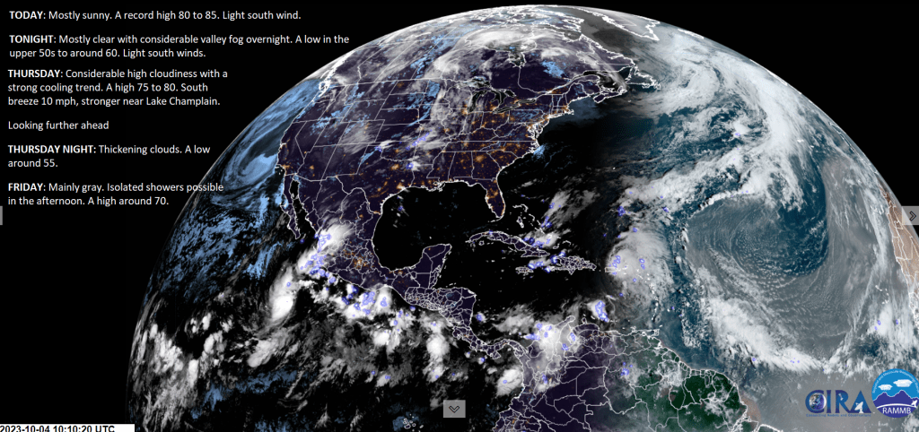
TODAY: Mostly sunny. A record high 80 to 85. Light south wind.
TONIGHT: Mostly clear with considerable valley fog overnight. A low in the upper 50s to around 60. Light south winds.
THURSDAY: Considerable high cloudiness with a strong cooling trend. A high 75 to 80. South breeze 10 mph, stronger near Lake Champlain.
Looking further ahead
THURSDAY NIGHT: Thickening clouds.A low around 55.
FRIDAY: Mainly gray.Isolated showers are possible in the afternoon. A high around 70.
SATURDAY: Overcast.Good chance for periods of rain or frequent showers, some moderate to briefly heavy with a rumble or two of thunder. A low in the low 60s. A high around 65.
SUNDAY: Morning clouds,. Chance for showers early, exiting in the afternoon give to a few breaks of afternoon sunshine. A low upper 40s to around 50. A high mid to upper 50s.
MONDAY: Clouds with intervals of sunshine.Scattered mountain sprinkles or brief showers. A low 40 to 45. A high in the mid-50s.
Average lows upper 30s to low 40s. Average highs upper 50s to lower 60s.
RH/10-4 forecast][end]
Blocking high pressure that has produced excellent dry weather days ends as a mini heatwave across the #GreenMountainState and greater #NewEngland. Excellent vacation weather is an understatement. But our reality this time of year is that colder outbreaks of weather are on the way, including clouds and generally grayer conditions than what we have been lucky to experience. Rain could come down rather hard, maybe even a little #thunder for Saturday, also some extra moisture from #Philippe.
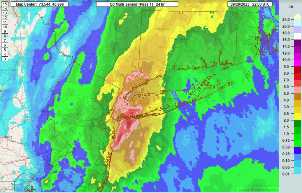
That’s a lot of rain for a metro area…with a super moist southeasterly flow, does this sound familiar. Synoptically it was all flow less an area of low pressure. 7.97″ fell in an urban area, and was the wettest day since 1948 for New york City.
