Updated Monday Morning Forecast — October 9th, 2023

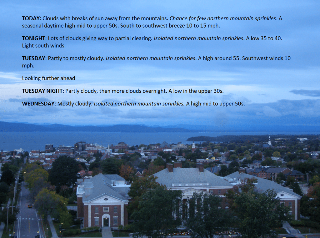
TODAY: Clouds with breaks of sun away from the mountains. Chance for a few northern mountain sprinkles.A seasonal daytime high mid to upper 50s. South to southwest breeze 10 to 15 mph.

TONIGHT: Lots of clouds giving way to partial clearing. Isolated northern mountain sprinkles. A low 35 to 40. Light south winds.

TUESDAY: Partly to mostly cloudy. Isolated northern mountain sprinkles. A high around 55. Southwest winds 10 mph.

Looking further ahead

TUESDAY NIGHT: Partly cloudy, then more clouds overnight. A low in the upper 30s.

WEDNESDAY: Mostly cloudy. Isolated northern mountain sprinkles. A high mid to upper 50s.

THURSDAY: Partly cloudy. Widely scattered light showers. A low in the upper 30s. A high around 55.

FRIDAY: Mostly cloudy northern areas with a slight chance for shower. Mixed sun and clouds elsewhere. A low in the mid-30s. A touch frost possible coldest hollows. A high in the mid-50s.

Average lows 35 to 40. Average highs 55 to 60.

RH/10-9 forecast][end]

Updated Friday Evening Forecast — October 6th, 2023

TONIGHT: Cloudy. A rising chance for showers across mainly southern and western Vermont. A bit humid and damp.A low near 60. Southeast breeze 10 mph.

TOMORROW: Gray, damp, and breezy at times. An occasional light shower, especially in western areas, becomes numerous and heavier later. A high near 65. Southeast breeze 10 mph shifting to northwesterly late.

SATURDAY NIGHT: Showers…or periods of rain…moderate to heavy for a time in the evening. Maybe a rumble of thunder. Partial clearing develops in late southern and central areas. A low in the mid to upper 40s. Southwest winds 10 to 20 mph & blustery.

SUNDAY: Morning clouds & lingering showers in the north early, otherwise intervals of sun, blustery and colder.  Isolated leftover mountain sprinkles.A high ranging in the mid to upper 50s. South to southwest winds 10 mph.

Looking further ahead

SUNDAY NIGHT: Mostly clear or becoming so.A low upper 30s to near 40.

MONDAY: Partly to mostly cloudy northern and western areas with a chance for a shower. Mixed sun and clouds otherwise. A chilly daytime high in the low 50s.

TUESDAY: Sunshine mixed with clouds. Scattered showers developing late. A low 35 to 40 with pockets of frost is possible. A high near 55.

WEDNESDAY: Mixed sun and clouds and isolated showers. A low around 40. A high 55 to 60. 

Average lows upper 30s to low 40s. Average highs upper 50s to lower 60s.

RH/10-6 forecast][end]

Updated Friday morning Forecast — October 6th, 2023

TODAY: Cloudy.Isolated light sprinkles or showers mainly in southern areas this afternoon.A high near 70. South breeze 10 to 15 mph.

TONIGHT: Cloudy. A rising chance for showers across mainly southern and western Vermont. A bit humid and damp.A low near 60. Southeast breeze 10 mph.

SATURDAY: Gray, damp, and breezy with an occasional shower becoming more numerous and heavier in western areas later in the afternoon. A high of about 65. Southeast breeze 10 mph shifting to northwesterly late.

Looking further ahead

SATURDAY NIGHT: Cloudy. Showers…or periods of rain…moderate to heavy for a time. Maybe a rumble of thunder. A low in the mid-40s.

SUNDAY: Morning clouds with lingering showers likely. Turning blustery with partial afternoon clearing and isolated leftover sprinkles.A high in the mid to upper 50s.

MONDAY: Lots of clouds in northern and western areas with a chance for mountain sprinkles or brief showers, otherwise mixed sun and clouds. A low near 40. A high 50 to 55.

TUESDAY: Sunshine mixed with clouds. Scattered showers developing late. A low 35 to 40. A high near 55.

WEDNESDAY: Mixed sun and clouds and isolated showers. A low around 40. A high 55 to 60. 

Average lows upper 30s to low 40s. Average highs upper 50s to lower 60s.

RH/10-6 forecast][end]

Updated Thursday evening forecast — October 5th, 2023

TONIGHT: Gradually thickening clouds. A low around 55.South to southeast breeze 10 mph, stronger near Lake Champlain.

TOMORROW: Cloudy.A rising chance for showers mainly in southern and eastern Vermont. A high in the upper 60s. South breeze 10 to 15 mph.

FRIDAY NIGHT: Cloudy. A rising chance for showers across western areas after midnight. A low around 60. Southeast breeze 10 mph.

SATURDAY: Gray.Breezy. Scattered showers. A high in the mid-60s. Southeast breeze 10 mph.

Looking further ahead

SATURDAY NIGHT: Cloudy. Showers are likely, some moderate at times with a few rumbles of thunder possible in the evening. A low in the mid-40s.

SUNDAY: Morning clouds with lingering showers likely. Turning blustery with partial afternoon clearing and isolated leftover sprinkles.A high in the upper 50s.

MONDAY: Lots of clouds in northern and western areas with a chance for mountain sprinkles or brief showers, otherwise mixed sun and clouds. A low 40 to 45. A high in the low 50s.

TUESDAY: Sunshine mixed with clouds. A low upper 30s to around 40. A high in the low to mid-50s.

WEDNESDAY: Mixed sun and clouds. A low in the mid to upper 30s. A high near 60. 

Average lows upper 30s to low 40s. Average highs upper 50s to lower 60s.

RH/10-5 forecast][end]