Updated Wednesday evening Forecast — March 28th, 2018

TONIGHT: Partly cloudy.A low in the low to mid 30s. Little wind.

TOMORROW: Brief partial morning sun then clouding up. Light rain becoming likely late. Milder. A high 50 to 55, warmest western and southern areas. Light south wind.

THURSDAY NIGHT: Cloudy. Periods of light rain. Areas of fog. A low in the mid to upper 30s. Light southeast winds.

FRIDAY: Rain showers…possibly mixed with wet snow flakes higher northern terrain early, Becoming partly sunny later on. A high 45 to 50. Northwest winds 10 to 20 mph.

Looking further Ahead…

FRIDAY NIGHT: Mostly clear a bit blustery in the evening. A low around 20.

Full “Sap Moon“ 8:37 AM

SATURDAY: Clouds mixed with sun. A high 45 to 50.

EASTER SUNDAY: Chance for a round wet snow showers mixed with rain valley floors. A skiff of accumulation across higher elevations. Blustery with breaks of sun possible in the afternoon. A low near 32. A high in the 40s.

MONDAY: Partly sunny and colder. A low in the teens. A high in the 30s.

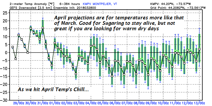
Average lows in the 20s. Normal highs in the mid to upper 40s
RH/3-28[end]

Virus-free. www.avast.com

Updated Wednesday morning Forecast — March 28th, 2018

TODAY: Any wet snow flakes or sprinkles exiting. Cloudsgradually give way to some intervals of late afternoon sun. A high upper 40s to around 50. Little wind. (Sap run)

TONIGHT: Partly cloudy.A low 30 to 35. Little wind.

THURSDAY: Brief partial morning sun then clouding up. Light rain becoming likely late. Milder. A high 50 to 55, warmest western and southern areas. Light south wind.

Looking further Ahead…

THURSDAY NIGHT: Cloudy. Periods of light rain. Areas of fog. A low in the mid to upper 30s.

FRIDAY: Rain showers…possibly mixed with wet snow flakes higher northern through in the morning, Becoming partly sunny later on. A high 45 to 50.

Full “Sap Moon“ 8:37 AM

SATURDAY: Clouds mixed with sun. A low around 20. A high 45 to 50.

EASTER SUNDAY: Chance for a round wet snow showers mixed with rain valley floors. A skiff of accumulation across higher elevations. Blustery with breaks of sun possible in the afternoon. A low near 32. A high in the 40s.

MONDAY: Partly sunny and colder. A low in the teens. A high in the 30s.

Average lows in the 20s. Normal highs in the mid to upper 40s

RH/3-28[end]

Virus-free. www.avast.com

Updated Tuesday Evening forecast — March 27th, 2018

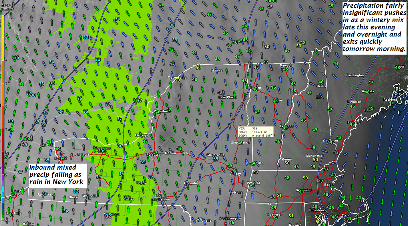
TONIGHT: Cloudy. Occasional light wintery mix arriving later this evening. Watch for slick travel especially east of the Green Mountains. A low around freezing or 32. Southeast winds 10 mph.

TOMORROW: A couple leftover rain showers exiting mid morning, otherwise clouds gradually giving way to some intervals of late afternoon sun. A high mid to upper 40s. Little wind. (Sap run)

WEDNESDAY NIGHT: Partly cloudy.A low 30 to 35. Little wind.

THURSDAY: A few breaks of morning sun, then overcast. A rising chance for light rain toward evening. A high ranging in the upper 40s to low 50s, warmest southern areas. Light south wind.

Looking further Ahead…

THURSDAY NIGHT: Cloudy. Periods of light rain. Areas of fog. A low in the mid to upper 30s.

FRIDAY: Rain showers…possibly mixed with wet snow flakes higher northern through in the morning, Becoming partly sunny later on. A high 45 to 50.

Full Sap Moon 8:37 AM

SATURDAY: Clouds mixed with sun. A low around 20. A high 45 to 50.

EASTER SUNDAY: Mostly cloudy. Chance for rain or wet snow showers. A low 25 to 30. A high mid 40s to around 50.

Average lows in the 20s. Normal highs in the mid to upper 40s

RH/3-27[end]

Virus-free. www.avast.com

Updated Tuesday morning forecast — March 27th, 2018

TODAY: Sunshine becoming filtered by high clouds thickening up later this afternoon. Near seasonal temperatures. A high in the mid to upper 40s. Light winds. (Sap Run)

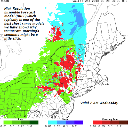
TONIGHT: Cloudy. A rising chance for a light wintery mix producing slick travel late evening on east of the Green Mountains. A low in the lower 30s. South winds 10 mph.

WEDNESDAY: Chance for rain shower early, then clouds give way to afternoon intervals of sunshine. A high mid to upper 40s. Little wind. (Sap run)

Looking further Ahead…

WEDNESDAY NIGHT: Fair and dry but with high cloudiness. A low around 35.

THURSDAY: Gray. Isolated sprinkles developing…with occasional light rain in the afternoon. Areas of fog. A high ranging in the low 40s to around 50 warmest toward southern areas.

FRIDAY: Rain showers mixed with wet snow flakes across the higher terrain early, Otherwise becoming partly sunny. A low in the mid to upper 30s. A high in the mid 40s to near 50.

Full Sap Moon 8:37 AM

SATURDAY: Clouds mixed with sun. A low around 20. A high in the mid to upper 40s

EASTER SUNDAY: Sunshine giving way to clouds. Chance for rain or wet snow developing late. A low 25 to 30. A high around 50.

Average lows in the 20s. Normal highs in the mid to upper 40s

RH/3-27[end]

Virus-free. www.avast.com

Updated Monday Evening Forecast — March 26th, 2018

TONIGHT: Clear & partially moonlit. A low in the lower teens to low 20s. Light southeast winds.

TOMORROW: Sunshine becoming filtered by high clouds. A high mid 40s to near 50. Light winds. (Sap Run)

TUESDAY NIGHT: Thickening clouds. A rising chance for a light wintery mix producing slick travel toward daybreak east of the Green Mountains. A low in the lower 30s. South winds 10 mph.

WEDNESDAY: Chance for rain shower early, then considerable cloudiness. A high mid to upper 40s. Little wind. (Sap run)

Looking further Ahead…

WEDNESDAY NIGHT: Mostly cloudy. A low around 35.

THURSDAY: Gray. Isolated sprinkles developing…with occasional light rain in the afternoon. Areas of fog. A high ranging in the low 40s to around 50 warmest toward southern areas.

FRIDAY: Rain showers mixed with wet snow flakes across the higher terrain early, Otherwise becoming partly sunny. A low in the mid to upper 30s. A high in the upper 40s to mid 50s.

SATURDAY: Clouds mixed with sun. A low around 20. A high around 45.

EASTER SUNDAY: Sunshine giving way to clouds. Chance for rain developing late. A low in the low 20s. A high in the low 50s.

Average lows in the 20s. Normal highs in the mid to upper 40s

RH/3-26[end]

Virus-free. www.avast.com

Updated Monday morning Forecast — March 26th, 2018

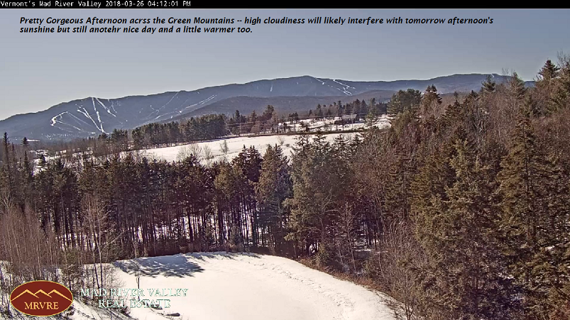
TODAY: Pick of the week. Sunny and gorgeous. A high in the low 40s. Little wind. (Maybe a sap run)

TONIGHT: Clear & partially moonlit. A low mid teens to low 20s. Light southeast winds.

TUESDAY: Sunshine becoming filtered by high clouds. A high near 45. Light northwest winds.

Looking further Ahead…

TUESDAY NIGHT: Thickening clouds. A rising chance for a light wintery mix producing slick travel toward daybreak. A low in the low 30s.

WEDNESDAY: Chance for rain shower early, then mainly cloudy. A high mid to upper 40s. (Maybe a sap run)

THURSDAY: Considerable cloudiness. Chance for light rain developing toward evening. A morning low close to 32. A high mid 40s to low 50s.

FRIDAY: Morning clouds with slight chance for passing rain shower. Partial afternoon sun developing. A low in the 30s. A high 50 to 55.

Average lows in the 20s. Normal highs in the mid to upper 40s

RH/3-26[end]

Virus-free. www.avast.com

Updated Friday Evening forecast — March 23rd, 2018

TONIGHT: Considerable cloudiness. A few stray flurries toward the Champlain valley overnight. A low upper teens to mid 20s. Northwest winds 10 mph.

TOMORROW: Clouds with a few breaks of sun possible. A stray flurry or two across mainly northern areas in the afternoon. A high 30 to 35. Northwest winds 10 to 15 mph.

SATURDAY NIGHT: Mostly cloudy with widely scattered light snow showers or flurries with a dusting to less than an inch. A low 15 to 20. Light north winds.

SUNDAY: A stray flurry or two early, Otherwise intervals of afternoon sunshine. A high in the mid to upper 30s. Northeast winds 10 mph.

Looking further Ahead…

SUNDAY NIGHT: Clear & partially moonlit. A low in the teens.

MONDAY: Mostly sunny. Start of a warming trend. A high around 40. (Maybe a sap run)

TUESDAY: Sunshine filtered by high clouds. A low in the teens. Milder in the afternoon. A high 45 to 50. (Sap run)

WEDNESDAY: Partly sunny then clouding up. Chance for light rain showers arriving late. Above normal temperatures. A low around 20. A high 45 to 50. (Sap run)

THURSDAY: Considerable cloudiness. Chance for sprinkles. A low in the mid to upper 30s. A high 50 to 55.

Average lows upper teens to mid 20s. Normal highs upper 30s to mid 40s.

RH/3-23[end]

Virus-free. www.avast.com

Updated Friday Morning Forecast — March 23rd, 2018

TODAY: More clouds than sun. A high in the upper 30s to near 40. Northwest winds 10 to 15 mph.

TONIGHT: Considerable cloudiness. A low mid teens to low 20s. Northwest winds 10 mph.

SATURDAY: Clouds with a few breaks of sun possible. A stray flurry or two across mainly northern areas. A high 30 to 35. Northwest winds 10 to 15 mph.

Looking further Ahead…

SATURDAY NIGHT: Mostly cloudy with widely scattered light snow showers or flurries with a dusting to an inch. A low in the teens.

SUNDAY: A few leftover stray flurries. Otherwise lots of clouds… giving way to intervals late afternoon sunshine. A high in the mid to upper 30s.

MONDAY: Mostly sunny. Start of a warming trend. A low in the teens. A high near 40. (Maybe a sap run)

TUESDAY: Sunshine becoming filtered by high clouds. A low in the teens. Milder. A high in the mid to upper 40s. (Sap run)

WEDNESDAY: Sunshine mixed with clouds. Above normal temperatures. A low around 20. A high around 50.

THURSDAY: Considerable cloudiness. Chance for sprinkles. A low in the 30s. A high in the 50s.

Average lows upper teens to mid 20s. Normal highs upper 30s to mid 40s.

RH/3-23[end]

Virus-free. www.avast.com

Updated Thursday Evening Forecast — March 22nd, 2018

TONIGHT: Partly cloudy. A low mid teens to low 20s. Light northwest winds.

TOMORROW: More clouds than sun. A high 35 to 40. Northwest winds 10 to 15 mph.

FRIDAY NIGHT: Partly cloudy. A low mid teens to low 20s. Northwest winds 10 mph.

SATURDAY: Partly sunny early, then clouding up. Chance for flurries toward evening. A high 30 to 35. Northwest winds 10 to 15 mph.

Looking further Ahead…

SATURDAY NIGHT: Mostly cloudy with widely scattered light snow showers or flurries with little more than dusting. A low in the teens.

SUNDAY: A few stray flurries. Otherwise lots of clouds… giving way to intervals late afternoon sunshine. A high in the mid to upper 30s.

MONDAY: Mostly sunny. Start of a warming trend. A low in the teens. A high near 40. (Maybe a sap run)

TUESDAY: Sunshine becoming filtered by high clouds. A low in the teens. Milder. A high in the mid to upper 40s. (Sap run)

WEDNESDAY: Sunshine mixed with clouds. Above normal temperatures. A low around 20. A high around 50.

THURSDAY: Considerable cloudiness. Chance for sprinkles. A low in the 30s. A high in the 50s.

Average lows upper teens to mid 20s. Normal highs upper 30s to mid 40s.

RH/3-22[end]

Virus-free. www.avast.com

Updated Thursday Morning Forecast — March 22nd, 2018

TODAY: Widely Scattered flurries far southeastern areas in the morning. Otherwise clouds with intervals of afternoon sun. A high in the mid 30s. North to northwest winds 10 to occasionally 20 mph.

TONIGHT: Partly cloudy. A low in the mid teens. Light northwest winds.

FRIDAY: Clouds mixing with intervals of afternoon sunshine. A high 35 to 40. Northwest winds 10 to occasionally 20 mph.

Looking further Ahead…

FRIDAY NIGHT: Scattered clouds. A low around 15.

SATURDAY: Partly sunny early, then clouding up. Chance for flurries toward evening. A high 32 to 35.

SUNDAY: Scattered morning snow showers and valley flurries wind down. Less than an inch of accumulation. Otherwise lots of clouds… giving way to intervals late afternoon sunshine. A low in the mid teens. A high in the mid 30s.

MONDAY: Mostly sunny. Start of a warming trend. A low 5 to 15 above. A high near 40. (Maybe a sap run)

TUESDAY: Sunshine becoming filtered by high clouds. A low in the single digits to low teens. Milder. A high 45 to 50. (Sap run)

WEDNESDAY: Sunshine mixed with clouds. Above normal temperatures. A low in the mid 20s. A high around 50.

THURSDAY: Considerable cloudiness. Chance for sprinkles. A low in the 30s. A high in the 50s.

Average lows upper teens to mid 20s. Normal highs upper 30s to mid 40s.

RH/3-22[end]

Virus-free. www.avast.com