Updated Monday Evening Forecast — May 27th, 2024

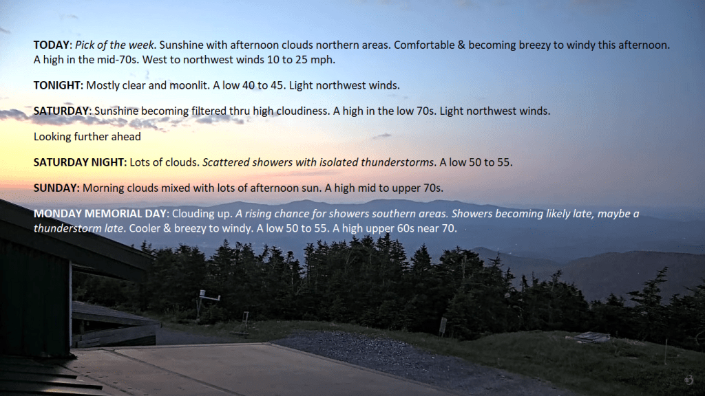
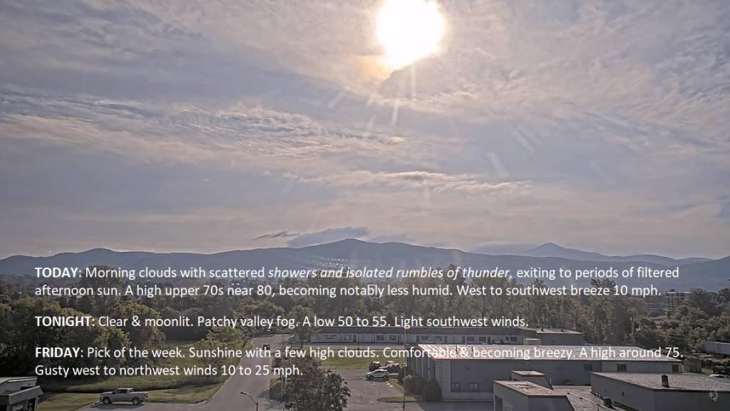
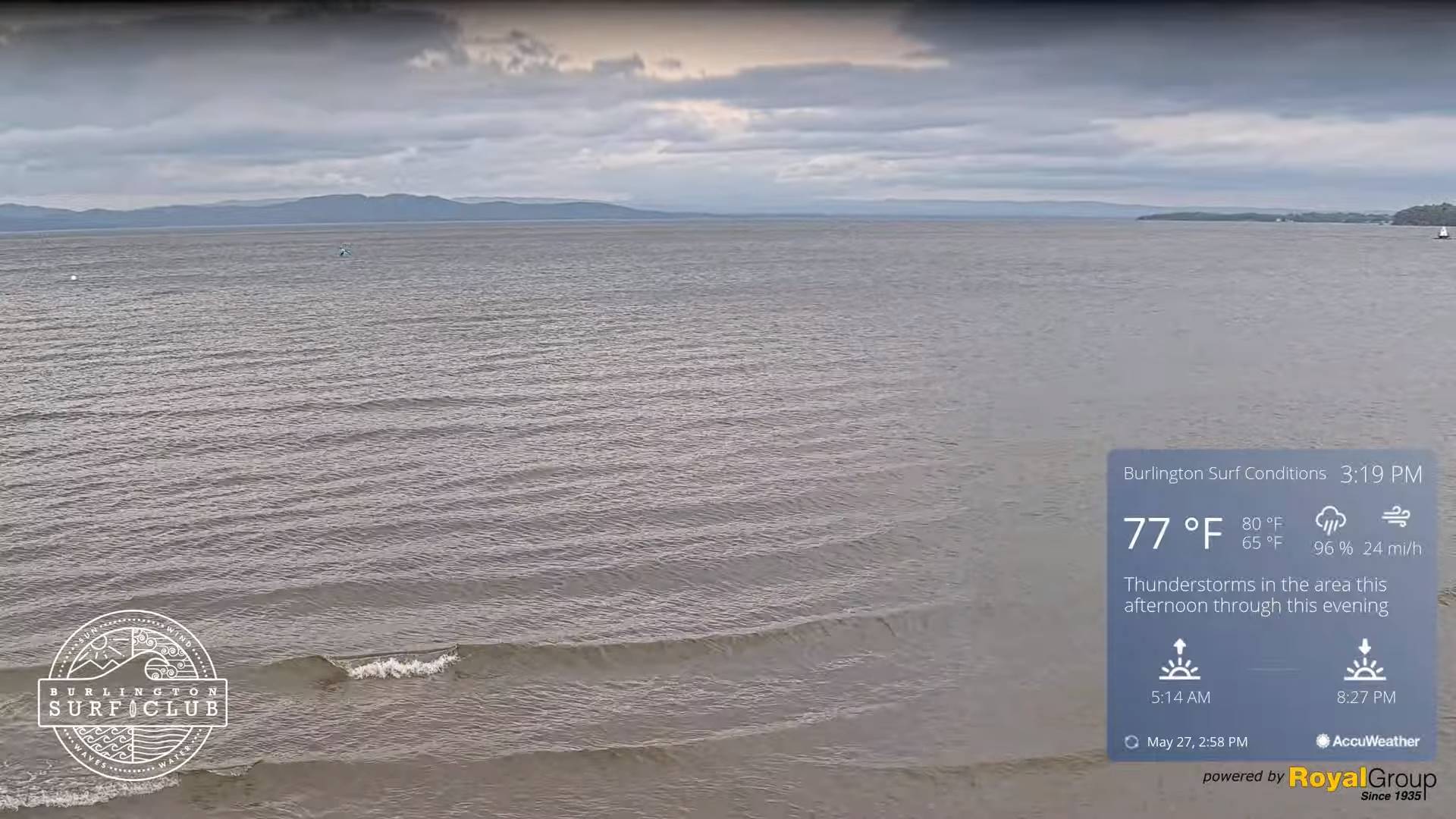
TONIGHT: Showers this evening…& a few embedded thunderstorms moderate to briefly heavy this evening, becoming scattered overnight with partial clearing. A low in the low 60s. South winds 10 to 15 mph falling off overnight.

TOMORROW: Partly sunny. Widely scattered showers, maybe an isolated rumble of thunder Champlain Valley. A high 70 to 75. West to southwest breeze 10 to 20 mph.

TUESDAY NIGHT: Partly to mostly cloudy. Slight chance for a sprinkle. A low 50 to 55. Light northwest winds.

WEDNESDAY: Low cloudiness gradually mixing with intervals of sun. Slight chance for a sprinkle. A high in the mid-60s. Northwest breeze 10 mph.

Looking further ahead

WEDNESDAY NIGHT: Mostly clear, then some clouds late.A low around 45.

THURSDAY: More sun than clouds. Cool. A high 60 to 65.

FRIDAY: Morning sun, then more afternoon clouds. A low in the low to mid 40s. A high 60 to 65.

SATURDAY: Sunshine becoming filtered through high clouds.

Average lows mid-40s to near 50. Average highs in the upper 60s to lower 70s.

Start of meteorological summer June 6th

RH/5-27forecast][end]

Updated Monday Memorial Day Forecast — May 27th, 2024

TODAY: Mainly cloudy. Scattered sprinkles southern areas gradually spread north later this morning. Damp cooler and breezy to windy. A high in the upper 60s. Southeasterly winds 10 to 25 mph with higher gusts across western slopes and of the Greens.

TONIGHT: Cloudy. Showers this evening…a few & embedded thunderstorms moderate to briefly heavy especially western areas this evening…becoming scattered overnight. A low in the low 60s. South winds 10 to 15 mph falling off overnight.

TUESDAY: Mixed clouds and sun. Scattered showers, maybe an isolated rumble of thunder western areas. A high 70 to 75. West to southwest breeze 10 to 20 mph.

Looking further ahead

TUESDAY NIGHT: Partly to mostly cloudy. Chance for a few lingering showers. A low 50 to 55.

WEDNESDAY: Low cloudiness gradually mixing with intervals of sun. A high in the mid-60s.

THURSDAY: Sunshine mixing with a few clouds. Cool. A low around 45. A high 60 to 65.

FRIDAY: Morning sun, then more afternoon clouds. A low in the low to mid 40s. A high 60 to 65.

Average lows mid-40s to near 50. Average highs in the upper 60s to lower 70s.

Start of meteorological summer June 6th

RH/5-27forecast][end]

Updated Friday Evening Forecast — May 24th, 2024

TONIGHT: Clear and partially moonlit.A low 40 to 45. Light northwest winds.

TOMORROW: Sunshine becoming filtered thru high cloudiness. A high in the low 70s. Light northwest winds.

SATURDAY NIGHT: Increasing clouds. Scattered showers with isolated thunderstorms.A low about 55. Light southeast winds.

SUNDAY: Morning clouds mixed with lots of afternoon sun. A high mid to upper 70s. Light northwest winds.

Looking further ahead

SUNDAY NIGHT: Clear early, then thickening clouds.A low mid-50s

MONDAY MEMORIAL DAY: Mainly cloudy. Scattered sprinkles southern areas becoming more frequent later on, possible rumbles of thunder. Cooler & breezy to windy. A high upper 60s near 70.

TUESDAY: Variable clouds. Chance for a shower & breezy. A low in the upper 50s to around 60. A high in the lower 70s.

WEDNESDAY: Low cloudiness gradually mixing with intervals of sun. A low 50 to 55. A high in the mid-60s.

Average lows range thru the 40s. Average highs mid-60 to low 70s.

Start of meteorological summer June 6th

RH/5-24forecast][end]

Updated Friday Morning Forecast — May 24th, 2024

TODAY: Pick of the week. Sunshine with afternoon clouds northern areas. Comfortable & becoming breezy to windy this afternoon. A high in the mid-70s. West to northwest winds 10 to 25 mph.

TONIGHT: Mostly clear and moonlit.A low 40 to 45. Light northwest winds.

SATURDAY: Sunshine becoming filtered thru high cloudiness. A high in the low 70s. Light northwest winds.

Looking further ahead

SATURDAY NIGHT: Lots of clouds. Scattered showers with isolated thunderstorms.A low 50 to 55.

SUNDAY: Morning clouds mixed with lots of afternoon sun. A high mid to upper 70s.

MONDAY MEMORIAL DAY: Clouding up. A rising chance for showers southern areas. Showers becoming likely late, maybe a thunderstorm late. Cooler & breezy to windy. A low 50 to 55. A high upper 60s near 70.

TUESDAY: Variable clouds. Chance for a shower & breezy. A low in the upper 50s to around 60. A high in the lower 70s.

WEDNESDAY: Low cloudiness gradually mixing with intervals of sun. A low 50 to 55. A high in the mid-60s.

Average lows range thru the 40s. Average highs mid-60 to low 70s.

Start of meteorological summer June 6th

RH/5-24forecast][end]

Updated Thursday Evening forecast — May 23rd, 2024

TONIGHT: Clear & moonlit. Patchy valley fog.A low 50 to 55. Light southwest winds.

TOMORROW: Pick of the week. Sunshine with a few clouds far northern areas. Comfortable & becoming breezy. A high in the mid-70s. West to northwest winds 10 to 25 mph.

FRIDAY NIGHT: Mostly clear and moonlit.A low in the low to mid-40s. Light northwest winds.

SATURDAY: Filtered sunshine giving way thickening clouds late. A high around 70. Light northwest winds.

Looking further ahead

SATURDAY NIGHT: Lots of clouds. Scattered showers.A low 50 to 55.

SUNDAY: Morning clouds mixed with lots of afternoon sun. A high mid to upper 70s.

MONDAY MEMORIAL DAY: Thickening clouds, leading to the chance for showers & possible thunder late. Cooler. A low in the mid-50s. A high 70 to 75.

TUESDAY: Variable clouds. Chance for a shower. A low in the mid to upper-50s. A high upper 60s near 70.

Average lows range thru the 40s. Average highs mid-60 to low 70s.

Start of meteorological summer June 6th

RH/5-23forecast][end]

Updated Thursday Morning Forecast — May 23rd, 2024

TODAY: Morning clouds with scattered showers and isolated rumbles of thunder, exiting to periods of filtered afternoon sun. A high upper 70s near 80, becoming notably less humid. West to southwest breeze 10 mph.

TONIGHT: Clear & moonlit. Patchy valley fog.A low 50 to 55. Light southwest winds.

FRIDAY: Pick of the week. Sunshine with a few high clouds. Comfortable & becoming breezy. A high around 75. Gusty west to northwest winds 10 to 25 mph.

Looking further ahead

FRIDAY NIGHT: Mostly clear with a more clouds overnight.A low mid to upper 40s.

SATURDAY: Lots of sunshine & seasonable giving way to late day cloudiness with scattered showers possible northern areas Saturday night. A high in the lower 70s.

SUNDAY: Morning clouds with a threat for a shower far north. Otherwiseclouds mixed with lots of afternoon sun.A low around 55. A high in the upper 70s.

MONDAY MEMORIAL DAY: Mainly gray. Chance for showers with a rumble of thunder. Cooler. A low around 55. A high near 75.

TUESDAY: Morning clouds then intervals of sun. Chance for a shower late. A low in the mid-50s. A high 65 to 70.

Average lows range thru the 40s. Average highs mid-60 to low 70s.

Start of meteorological summer June 6th

RH/5-23forecast][end]