
Unsettled morning with threatening showers followed by partial sunshine and a cooler and less humid day today, with a nice northwesterly breeze. 2nd pick of this week – tomorrow great weather for hard sweaty labor…dry and sunny.

TONIGHT: Cloudy. A period of rain or shower, moderate at times arriving late evening, before exiting to partial clearing daybreak. A low about 60. Light variable winds.
TOMORROW: Mixed sun and clouds. A few passing showers, maybe a rumble of thunder in the afternoon. Moderately humid. A high about 70. Northwest breeze 10 to 15 mph.
THURSDAY NIGHT: Clear & partially moonlit. Patchy valley fog. A low near 50. Light northwest winds.
FRIDAY: Sunshine & cool after patchy valley fog. A high upper 60s around 70. Light northwest winds.
Looking further ahead
FRIDAY NIGHT: Increasing & thickening clouds.A low 50 to 55.
SATURDAY: Gray. Rising chance for showers, & a risk of embedded thunderstorms late afternoon. A high 70 to 75 and muggy.

SUNDAY: Transition day. Clouds with scattered leftover showers early, gives way to partial afternoon sunshine. More humid. A low 60 to 65. A high 75 to 80.
MONDAY: Mixed clouds and sun. Scattered showers with a risk for thunder. A low in the upper 50s. A high around 70.
Average lows low to mid 50s. Average high mid-70s to low 80s
RH/6-26forecast][end]
TODAY: A couple passing showers this morning, then filtered sunshine thru high clouds. Warmer and a little muggier with a high in the low 80s. West breeze 10 to 15 mph in the afternoon.
TONIGHT: Mainly cloudy. A period of rain or showers becoming likely late this evening before exiting to partial clearing around daybreak. A low in the low 60s. Light southwest winds.
THURSDAY: Mixed sun and clouds. A few passing showers with isolated rumbles of thunder mid-afternoon or so. Moderately humid. A high in the low 70s. West to northwest breeze 10 to 15 mph.
Looking further ahead
THURSDAY NIGHT: Clear & partially moonlit. Patchy valley fog. A low near 50.
FRIDAY: Mostly sunny and cool after patchy valley fog. A high upper 60s around 70.
SATURDAY: Gray. Rising chance for showers, & a risk of embedded thunderstorms in the evening. A low 50 to 55. A high upper 60s to low 70s and muggy.
SUNDAY: Transition day. Clouds with scattered leftover showers early, gives way to partial afternoon sunshine. More humid. A low 60 to 65. A high around 80.

MONDAY: Mixed clouds and sun. Scattered showers with a risk for thunder. A low in the upper 50s. A high around 70.
Average lows low to mid 50s. Average high mid-70s to low 80s
RH/6-24forecast][end]

TONIGHT: Becoming mostly cloudy. Rising chance for showers and an isolated rumble of thunder overnight. More muggy. A low in the mid-60s. Light south to southwest winds breezier near Lake Champlain.
TOMORROW: A leftover shower or two early, then partly to mostly sunny before more afternoon clouds. Warmer and a little muggier. A high in the low 80s. West breeze 10 to 15 mph in the afternoon.
WEDNESDAY NIGHT: Mainly cloudy. Good chance for showers and a few heavy thunderstorms possible southern areas. Partial clearing late. A low near 60. Light southwest winds.
THURSDAY: Mixed sun and clouds. A few passing showers with isolated rumbles of thunder mid-afternoon or so. A high 70 to 75. West to northwest breeze 10 to 15 mph.
Looking further ahead
THURSDAY NIGHT: Clear & partially moonlit. Patchy valley fog. A low about 50.
FRIDAY: Mostly sunny and cool after patchy valley fog. A high upper 60s.
SATURDAY: Mainly cloudy. Rising chance for rain or showers, maybe some rumbles of thunder in the evening. A low 50 to 55. A high in the 70s.
SUNDAY: Transition day. Clouds with a chance for lingering showers, gives way to periods of afternoon sunshine. More humid. A low in the lower 60s. A high in the low 80s.
Average lows low to mid 50s. Average high mid-70s to low 80s

RH/6-24forecast][end]

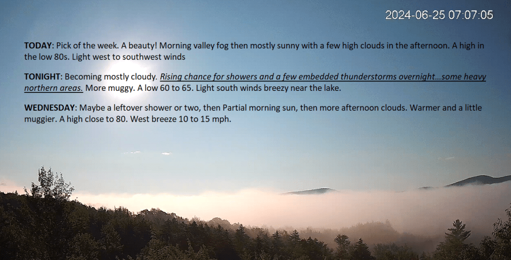
TODAY: Pick of the week. A beauty! Morning valley fog then mostly sunny with a few high clouds in the afternoon. A high in the low 80s. Light west to southwest winds
TONIGHT: Becoming mostly cloudy. Rising chance for showers and a few embedded thunderstorms overnight…some heavy northern areas. More muggy. A low 60 to 65. Light south winds breezy near the lake.
WEDNESDAY: Maybe a leftover shower or two, then Partial morning sun, then more afternoon clouds. Warmer and a little muggier. A high close to 80. West breeze 10 to 15 mph.

Looking further ahead
WEDNESDAY NIGHT: Mainly cloudy. Good chance for showers and a few heavy thunderstorms mainly southern areas. Partial clearing toward daybreak. A low near 60.
THURSDAY: Mixed sun and clouds. A few passing showers with isolated rumbles of thunder mid-afternoon or so. A high 70 to 75.
FRIDAY: Mostly sunny and cool after patchy valley fog. A low in the upper 40s. A high upper 60s.
SATURDAY: Mainly cloudy. Rising chance for rain or showers, maybe some rumbles of thunder in the evening. A low in the low 50s. A high in the 70s.
SUNDAY: Transition day. Clouds with a chance for lingering showers, gives way to periods of afternoon sunshine. More humid. A low around 60. A high around 80.

Average lows low to mid 50s. Average high mid-70s to low 80s
RH/6-24forecast][end]
TONIGHT: A few early showers dry up, then becoming mostly clear & partially moonlit with patchy valley fog. A low near 55. Light west to northwest winds.
TOMORROW: Pick of the week. A beauty! Morning valley fog then mostly sunny with a few high clouds in the afternoon. A high in the low 80s. Light west to southwest winds

TUESDAY NIGHT: Becoming mostly cloudy. Scattered showers late evening into the overnight. A low in the mid-60s. Light south winds breezy near the lake.
WEDNESDAY: Partial morning sun, then more afternoon clouds. Warmer and a little muggier. Chance for a shower or thunderstorm southern areas. A high in the low 80s. West breeze 10 to 15 mph.
Looking further ahead

WEDNESDAY NIGHT: Lots of clouds. Good chance for showers and few heavy thunderstorms. A low upper 50s.
THURSDAY: Clouds with some intervals of sun. A few mountain sprinkles. A high in the low 70s.
FRIDAY: Partly to mostly sunny. A low in the upper 40s. A high in the upper 60s.

SATURDAY: Mainly cloudy. A low in the low 50s. A high in the 70s.
Average lows low to mid 50s. Average high mid-70s to low 80s
RH/6-24forecast][end]

TODAY: Mixed sun and clouds give way to mostly cloudy skies. Chance for an afternoon shower or thunderstorm toward the Northeast Kingdom. A high in the upper 60s. Southwest winds becoming northwesterly 10 mph this afternoon.
TONIGHT: Becoming mostly clear & partially moonlit with patchy valley fog. A low 50 to 55. Light west winds.
TUESDAY: A beauty! Morning valley fog then mostly sunny with a few high clouds in the afternoon. A high in the lower 80s. Light northwest winds.

Looking further ahead
TUESDAY NIGHT: Evening cloudiness. Chance for an evening shower or thunderstorm…becoming mostly clear partially moonlit overnight. A low in the low to mid 60s.
WEDNESDAY: Morning sun, then more afternoon clouds. Warmer and more humid. Scattered afternoon thunderstorms mainly southern areas. A high 80 to 85.

THURSDAY: Some early morning clouds, then partly to sunny. A low 60 to 65. A high in the mid to upper 70s.
FRIDAY: Partly to mostly sunny. A low 45 to 50. A high in the upper 60s
Average lows low to mid 50s. Average high mid-70s to low 80s
RH/6-24forecast][end]
