
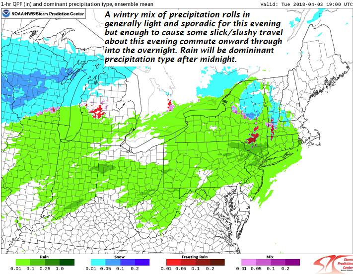
TODAY: Clouding up. A mix of rain, and slushy wet snow arrives late today. Watch for a few slick spots developing.. A high in the low to mid 40s. Light south wind.
TONIGHT: Cloudy. A wintry mix this evening… changing to rain with pockets of freezing rain. Watch for slick spots east of the Green Mountains mainly before midnight. A low close to 32. Southeast winds 10 to 20 mph.
WEDNESDAY: Cloudy but a break or two of sun possible. Occasional rain, or rain showers. Maybe a rumble of thunder toward southern areas. Areas of fog. Milder. A high in the mid 50s. Winds becoming southwesterly 10 to 20 mph.
Looking further Ahead…
WEDNESDAY NIGHT: Mostly cloudy and blustery to windy. Scattered mountain flurries. A low in the upper teens to low 20s. Strong westerly wind gusts possible.
THURSDAY: Partly to mostly sunny but very blustery and cold. A high in the low to mid 30s.
FRIDAY: Cloudy. Chance for accumulating snow mixing with rain valley floors. Becoming blustery to windy Friday night strong westerly wind gusts possible. A low 20 to 25. A high upper 30s to low 40s.
SATURDAY: Lots of clouds giving way to periods of afternoon sun.A low upper teens to mid 20s. A high in the upper 30s.
Average lows mid 20s to low 30s. Normal highs in the upper 40s to mid 50s.
RH/4-3[end]
| Virus-free. www.avast.com |
