Updated Friday morning Forecast — October 6th, 2023

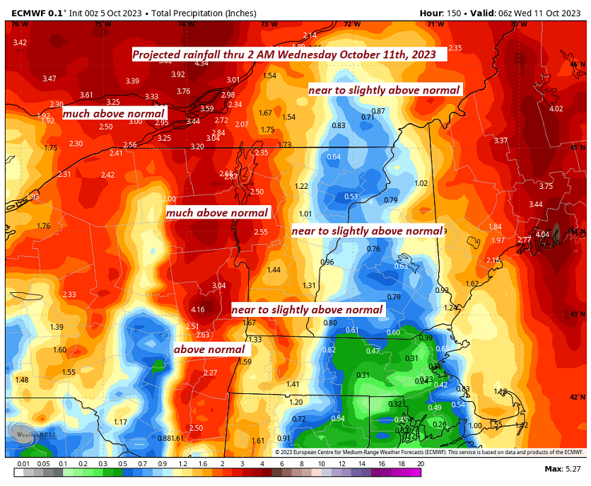
TODAY: Cloudy.Isolated light sprinkles or showers mainly in southern areas this afternoon.A high near 70. South breeze 10 to 15 mph.

TONIGHT: Cloudy. A rising chance for showers across mainly southern and western Vermont. A bit humid and damp.A low near 60. Southeast breeze 10 mph.

SATURDAY: Gray, damp, and breezy with an occasional shower becoming more numerous and heavier in western areas later in the afternoon. A high of about 65. Southeast breeze 10 mph shifting to northwesterly late.

Looking further ahead

SATURDAY NIGHT: Cloudy. Showers…or periods of rain…moderate to heavy for a time. Maybe a rumble of thunder. A low in the mid-40s.

SUNDAY: Morning clouds with lingering showers likely. Turning blustery with partial afternoon clearing and isolated leftover sprinkles.A high in the mid to upper 50s.

MONDAY: Lots of clouds in northern and western areas with a chance for mountain sprinkles or brief showers, otherwise mixed sun and clouds. A low near 40. A high 50 to 55.

TUESDAY: Sunshine mixed with clouds. Scattered showers developing late. A low 35 to 40. A high near 55.

WEDNESDAY: Mixed sun and clouds and isolated showers. A low around 40. A high 55 to 60. 

Average lows upper 30s to low 40s. Average highs upper 50s to lower 60s.

RH/10-6 forecast][end]

Updated Thursday evening forecast — October 5th, 2023

TONIGHT: Gradually thickening clouds. A low around 55.South to southeast breeze 10 mph, stronger near Lake Champlain.

TOMORROW: Cloudy.A rising chance for showers mainly in southern and eastern Vermont. A high in the upper 60s. South breeze 10 to 15 mph.

FRIDAY NIGHT: Cloudy. A rising chance for showers across western areas after midnight. A low around 60. Southeast breeze 10 mph.

SATURDAY: Gray.Breezy. Scattered showers. A high in the mid-60s. Southeast breeze 10 mph.

Looking further ahead

SATURDAY NIGHT: Cloudy. Showers are likely, some moderate at times with a few rumbles of thunder possible in the evening. A low in the mid-40s.

SUNDAY: Morning clouds with lingering showers likely. Turning blustery with partial afternoon clearing and isolated leftover sprinkles.A high in the upper 50s.

MONDAY: Lots of clouds in northern and western areas with a chance for mountain sprinkles or brief showers, otherwise mixed sun and clouds. A low 40 to 45. A high in the low 50s.

TUESDAY: Sunshine mixed with clouds. A low upper 30s to around 40. A high in the low to mid-50s.

WEDNESDAY: Mixed sun and clouds. A low in the mid to upper 30s. A high near 60. 

Average lows upper 30s to low 40s. Average highs upper 50s to lower 60s.

RH/10-5 forecast][end]

Updated Thursday Morning Forecast — October 5th, 2023

TODAY: Sunshine becoming filtered through high clouds, a little cooler with a high in the upper 70s. South breeze 10 mph, stronger near Lake Champlain.

TONIGHT: Thickening clouds.A low around 55. South to southeast breeze 10 mph stronger near Lake Champlain.

FRIDAY: Cloudy.A rising chance for showers mainly in southern and eastern Vermont. A high in the upper 60s. South breeze 10 to 15 mph.

Looking further ahead

FRIDAY NIGHT: Cloudy. Showers becoming likely across western areas. A low around 60.

SATURDAY: Overcast. Showers are likely, some moderate at times in western areas, with a few rumbles of thunder possible. Breezy. A high in the mid-60s.

SUNDAY: Partly cloudy, unsettled, and becoming blustery, with scattered showers.A low in the mid-40s. A high in the upper 50s.

MONDAY: More sun than clouds. Chance for mountain sprinkles or brief showers. A low 40 to 45. A high in the

low 50s.

TUESDAY: Partly to mostly cloudy. A low upper 30s to around 40. A high in the low to mid-50s.

WEDNESDAY: Mixed sun and clouds. A low in the mid to upper 30s. A high near 60. 

Average lows upper 30s to low 40s. Average highs upper 50s to lower 60s.

RH/10-5 forecast][end]

Updated Wednesday Evening Forecast — October 4th, 2023

TONIGHT: Mostly clear with considerable valley fog overnight. A low in the upper 50s to around 60. Light southeast breeze.

TOMORROW: Sunshine filtered thru high cloudiness with a strong cooling trend. A high 75 to 80. South breeze 10 mph, stronger near Lake Champlain.

THURSDAY NIGHT: Thickening high cloudiness.A low around 55.South to southeast breeze 10 mph stronger near Lake Champlain.

FRIDAY: Mostly cloudy.A rising chance for showers southern areas spreading north in the afternoon. A high around 70. South winds 10 to 20 mph.

Looking further ahead

FRIDAY NIGHT: Lots of clouds. Showers likely, a few moderate at times. A low in the low 60s

SATURDAY: Overcast.Good chance for frequent showers, some moderate to briefly heavy, maybe a rumble of thunder western areas. A high around 65.

SUNDAY: Variable cloudiness & unsettled with scattered showers.A low upper 40s. A high 50 to 55.

MONDAY: Mixed sun and clouds. Chance for mountain sprinkles or brief showers. A low 40 to 45. A high 50 to 55.

TUESDAY: Partly to mostly cloudy. A low 40 to 45. A high in the low to mid 50s.

Average lows upper 30s to low 40s. Average highs upper 50s to lower 60s.

RH/10-4 forecast][end]