Updated Thursday Morning Forecast — October 12th, 2023

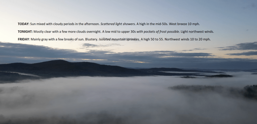
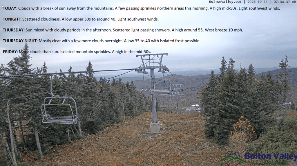
TODAY: Sun mixed with cloudy periods in the afternoon. Scattered light showers. A high in the mid-50s. West breeze 10 mph.

TONIGHT: Mostly clear with a few more clouds overnight.A low mid to upper 30s with pockets of frost possible. Light northwest winds.

FRIDAY: Mainly gray with a few breaks of sun. Blustery. Isolated mountain sprinkles. A high 50 to 55. Northwest winds 10 to 20 mph.

Looking further ahead

FRIDAY NIGHT: Variable clouds. A low upper 30s to around 40.

SATURDAY: High cloudiness thickening up in the afternoon. Slight chance for a shower or two. A high of about 55.

SUNDAY: Mostly cloudy. Slight chance for a shower or two. A low in the upper 30s. A high in the lower 50s.

MONDAY: Mainly gray & unsettled. Chance for showers. A low near 45. A high near 55.

TUESDAY: Partly to mostly cloudy. A low mid-30s to around 40. A high around 55.

WEDNESDAY: Considerable mainly high cloudiness. A low in the mid-30s. A high around 55.

Average lows 35 to 40 with a touch of frost. Average highs 55 to 60.

RH/10-12 forecast][end]

Updated Wednesday Evening Forecast — October 11th, 2023

TONIGHT: Scattered cloudiness.Slight chance for a passing sprinkle. A low upper 30s to around 40. Light southwest winds.

TOMORROW: Sun mixed with cloudy periods in the afternoon. Scattered light showers. A high around 55. West breeze 10 mph.

THURSDAY NIGHT: Mostly clear with a few more clouds overnight.A low 35 to 40 with isolated frost possible. Light northwest winds.

FRIDAY: Lots of clouds & blustery. Isolated mountain sprinkles. A high in the mid-50s. Northwest winds 10 to 20 mph.

Looking further ahead

FRIDAY NIGHT: Mostly clear, with more clouds overnight. A low in the 30s with pockets of frost.

SATURDAY: High cloudiness thickening up in the afternoon. Rising chance for showers southern areas. A high about 55.

SUNDAY: Gray. Widely scattered passing light showers. A low in the low 40s. A high 50 to 55.

MONDAY: Mainly cloudy & unsettled. Chance for showers. A low near 45. A high 50 to 55.

Average lows 35 to 40. Average highs 55 to 60.

RH/10-11 forecast][end]

Updated Wednesday Morning Forecast — October 11th, 2023

TODAY: Clouds with a break of sun away from the mountains. A few passing sprinkles northern areas this morning. A high mid-50s. Light southwest winds.

TONIGHT: Scattered cloudiness.A low upper 30s to around 40. Light southwest winds.

THURSDAY: Sun mixed with cloudy periods in the afternoon. Scattered light passing showers. A high around 55. West breeze 10 mph.

Looking further ahead

THURSDAY NIGHT: Mostly clear with a few more clouds overnight.A low 35 to 40 with isolated frost possible.

FRIDAY: More clouds than sun. Isolated mountain sprinkles. A high in the mid-50s.

SATURDAY: High cloudiness thickening up in the afternoon. Rising chance for showers southern areas. A low in the 30s with pockets of frost. A high about 55.

SUNDAY: Gray. Widely scattered passing light showers. A low in the low 40s. A high 50 to 55.

MONDAY: Mainly cloudy & unsettled. Chance for showers. A low near 45. A high 50 to 55.

Average lows 35 to 40. Average highs 55 to 60.

RH/10-11 forecast][end]

Updated Tuesday Evening Forecast — October 10th, 2023

TONIGHT: Partly to mostly cloudy. Isolated sprinkles early this evening and again toward daybreak. A low in the upper 30s to around 40. Light southeast winds.

TOMORROW: Clouds with a few breaks of sun. Maybe a northern mountain sprinkle. A high mid-50s. Light southwest winds.

WEDNESDAY NIGHT: Mostly clear or scattered clouds.A low upper 30s to around 40. Light southwest winds.

THURSDAY: Sun mixed with cloudy periods in the afternoon. Scattered light passing showers. A high around 55. West breeze 10 mph.

Looking further ahead

THURSDAY NIGHT: Mostly clear.A low 35 to 40 with isolated frost is possible.

FRIDAY: Brief morning sun, mixing with more clouds. Isolated mountain sprinkles. A high in the mid-50s.

SATURDAY: High cloudiness thickening up in the afternoon. Rising chance for periods of rain or showers in central and southern areas. A low in the 30s with pockets of frost. A high of about 55.

SUNDAY: Mainly gray. Widely scattered showers. A low around 40. A high 50 to 55.  

Average lows 35 to 40. Average highs 55 to 60.

RH/10-10 forecast][end]

Updated Tuesday Morning Forecast — October 10th, 2023

TODAY: Intervals of sun mixed with lots of clouds. Scattered late afternoon sprinkles or light showers. A high around 55. Southwest winds 10 mph.

TONIGHT: Partly to mostly cloudy Isolated sprinkles early. A low in the upper 30s to around 40. Light south winds.

WEDNESDAY: Clouds with a few breaks of sun. Isolated northern mountain sprinkles. A high mid to upper 50s. Light southwest winds.

Looking further ahead

WEDNESDAY NIGHT: Becoming mostly clear.A low near 40.

THURSDAY: Sun mixed with cloudy periods in the afternoon. Scattered light passing showers. A high around 55.

FRIDAY: Brief morning sun, mixing with more clouds. A low 35 to 40 with isolated frost possible. A high in the mid-50s.

SATURDAY: High cloudiness thickening up in the afternoon. Rising chance for periods of rain or showers central and southern areas. A low in the 30s with pockets of frost. A high about 55.

SUNDAY: Mainly gray. Widely scattered showers. A low around 40. A high 50 to 55.  

Average lows 35 to 40. Average highs 55 to 60.

RH/10-10 forecast][end]