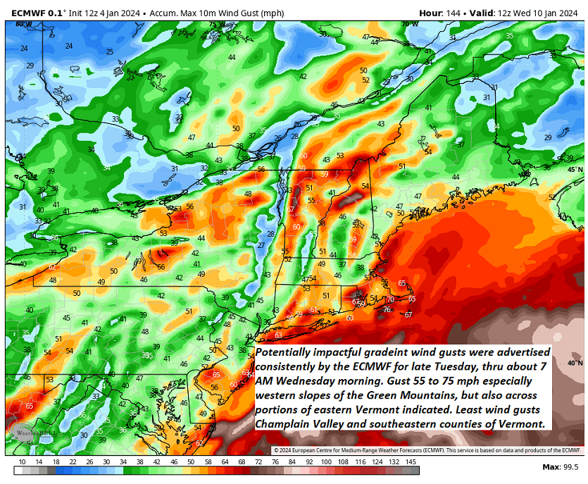
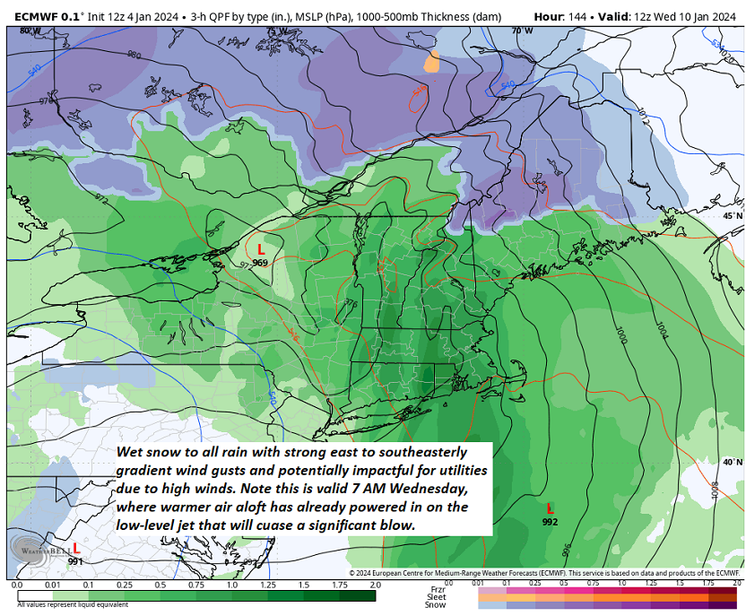
Enjoy what you can with our latest powder snowfall over the weekend. A nasty storm arrives late Tuesday into Wednesday morning with high winds fairly certain. The transition from wet snow to rain, another system could repeat Saturday.


TONIGHT: Mostly cloudy.Scattered flurries with a minor coating central and northern areas. A low near 20. Light west to northwest winds.
TOMORROW: Maybe an early hint of sun, otherwise lots of clouds. A high mid to upper 20s. Light east to southeast winds.
Winter Storm Watch Rutland and Windsor counties on south…

SATURDAY NIGHT: Overcast. A rising chance for light snow or flurries. A low ranging around 20. Easterly winds 10 mph.
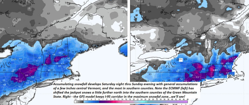
SUNDAY: Gray. Accumulating snow…moderate at times especially central and southern areas…winding down early evening. Accumulations of 1 to 4” far northern tier, 3 to 7” Barre-Montpelier, and 6 inches to locally a foot” across southern Green Mountains. A high in the low to mid-20s. Light northeast winds.
Looking further ahead

SUNDAY NIGHT: Lots of clouds. A few leftover flurries near the mountains especially in the evening.Lows upper teens to around 20
MONDAY: Mostly cloudy north, partly sunny central and south. A high 25 to 30.
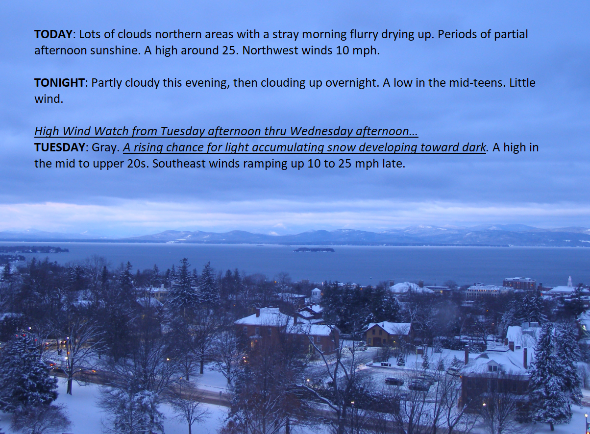
TUESDAY: Brief hints of morning sun, then thickening clouds. Slight chance for light accumulating snow toward dark. A low 10 to 15. A high near 30.

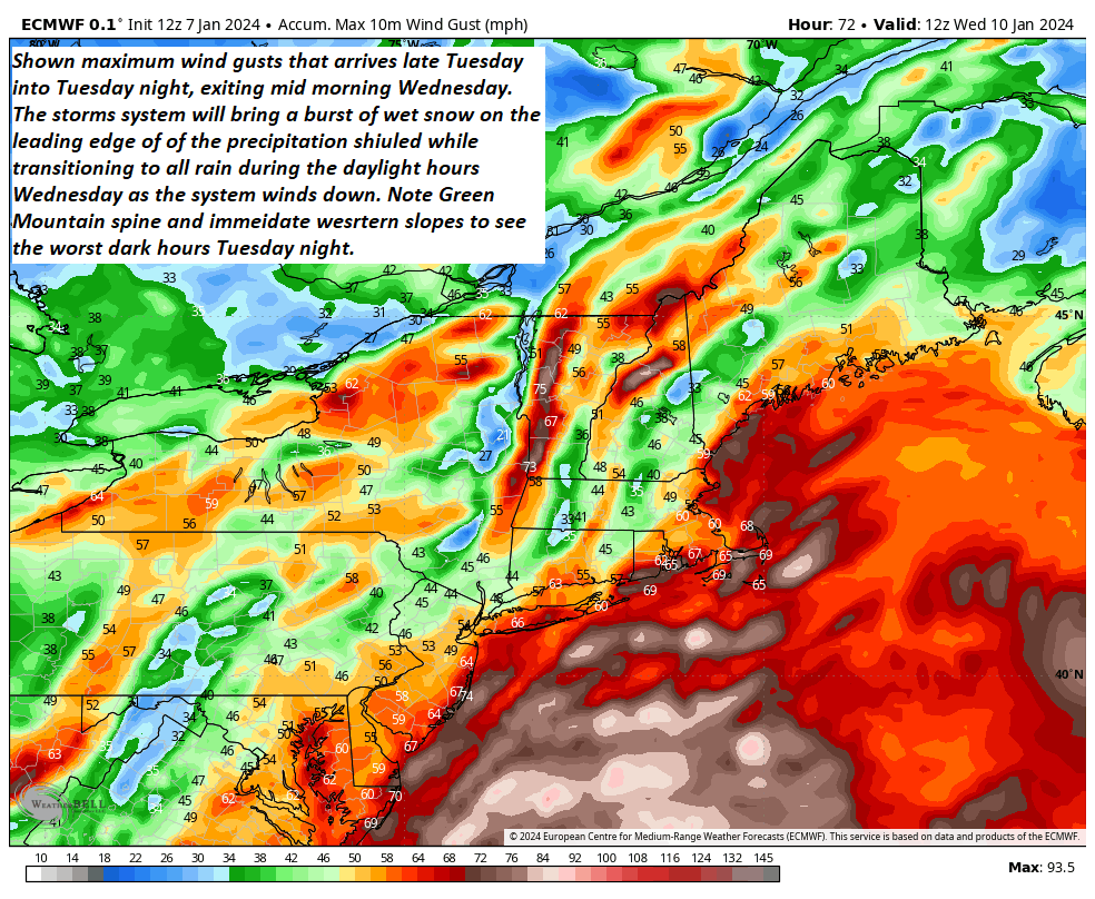
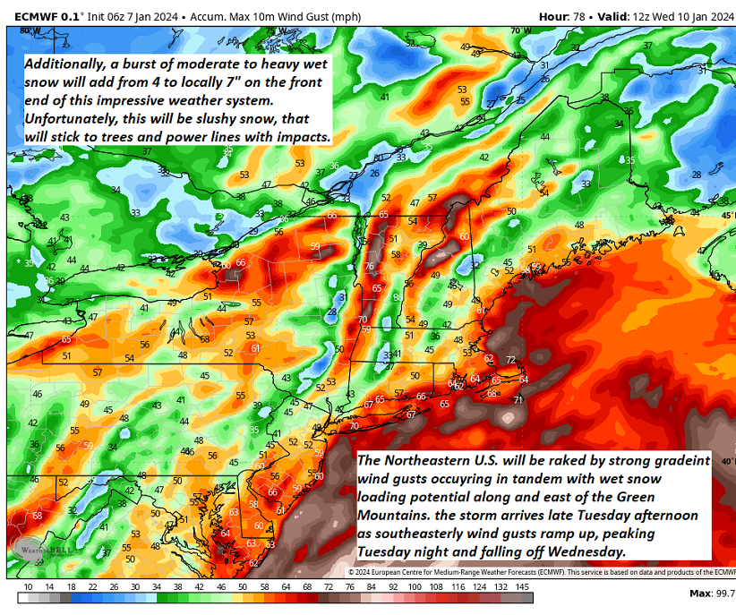
TUESDAY NIGHT – WEDNESDAY: Periods of wet accumulating snow…moderate to heavy at times transitions to mixed precipitation, then wind-blown rain, becoming lighter & showery in the afternoon. Breezy to windy with gusts exceeding 40 mph from the southeast. Temperatures near freezing Tuesday evening, rising into the 40s Wednesday afternoon.
Average lows single digits to around 10 above. Average highs mid-20s to around 30

RH/1-5forecast][end]

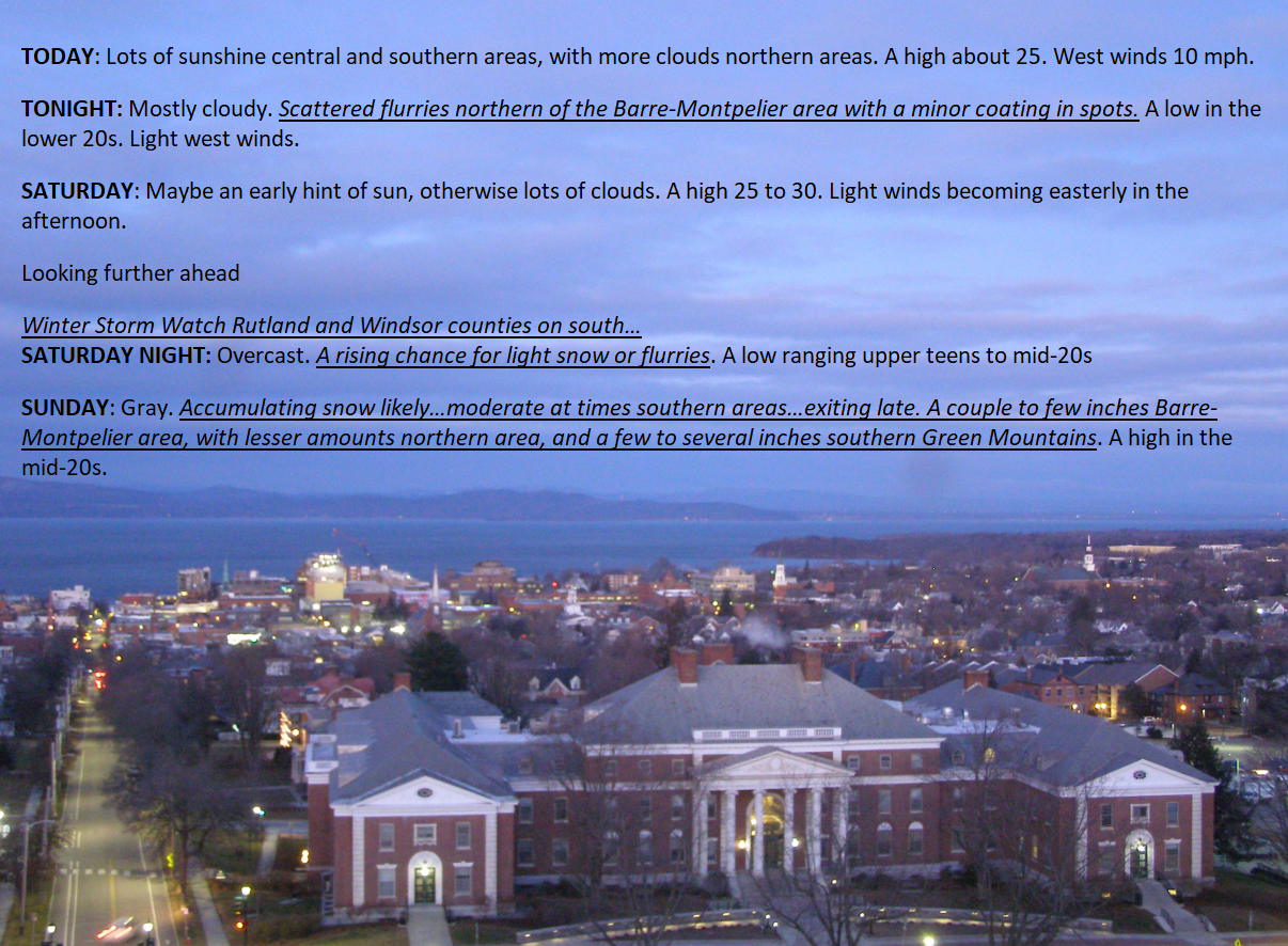
TODAY: Lots of sunshine central and southern areas, with more clouds northern areas. A high about 25. West winds 10 mph.
TONIGHT: Mostly cloudy.Scattered flurries northern of the Barre-Montpelier area with a minor coating in spots. A low in the lower 20s. Light west winds.
SATURDAY: Maybe an early hint of sun, otherwise lots of clouds. A high 25 to 30. Light winds becoming easterly in the afternoon.
Looking further ahead
Winter Storm Watch Rutland and Windsor counties on south…
SATURDAY NIGHT: Overcast. A rising chance for light snow or flurries. A low ranging upper teens to mid-20s
SUNDAY: Gray. Accumulating snow likely…moderate at times southern areas…exiting late. A couple to few inches Barre-Montpelier area, with lesser amounts northern area, and a few to several inches southern Green Mountains. A high in the mid-20s.
MONDAY: More clouds than sun. Lows upper teens to around 20. A high 25 to 30.
TUESDAY: Brief hints of sun, then cloudy. Slight chance for light accumulating snow toward dark. A low 10 to 15. A high near 30. 
TUESDAY NIGHT – WEDNESDAY: Periods of wet accumulating snow…moderate to heavy at times transitions to mixed precipitation, then wind-blown rain, becoming lighter & showery in the afternoon. Breezy to windy with gusts exceeding 40 mph from the southeast. Temperatures near freezing Tuesday evening, rising into the 40s Wednesday afternoon.
Average lows single digits to around 10 above. Average highs mid-20s to around 30
RH/1-5forecast][end]

TONIGHT: Some mountain clouds but generally mostly clear. A few high clouds overnight.A low mid-single digits to around 10 above. Light northwest winds.
TOMORROW: Sunshine with more clouds northern areas in the afternoon. Maybe a stray flurry Canadian border. A high about 25. West winds 10 mph.

FRIDAY NIGHT: Variable clouds.A stray northern border flurry.A low 15 to 20. Light west winds.
SATURDAY: Hints of early sun, then cloudy. A high mid-20s to near 30. Light southeast winds.
Looking further ahead
SATURDAY NIGHT: Overcast. A rising chance for light snow overnight. A low in the upper teens.
SUNDAY: Gray. Accumulating snow likely…moderate at times southern areas…exiting late. A few to several inches possible southern areas, lesser amounts north. A high around 25.
MONDAY: Mixed sun and clouds. Lows in the mid-teens. A high 25 to 30.
TUESDAY: Brief hints of sun, then cloudy. Slight chance for light accumulating snow toward dark. A low upper single digits to around 15 above. A high near 30.
Average lows single digits to around 10 above. Average highs mid-20s to around 30
RH/1-3forecast][end]
TODAY: Scattered light accumulating snow showers…a dusting to an inch this morning. Skies becomepartly to mostly sunny, and turning blustery this afternoon. Temperatures peak in the low 30s early, then falling thru the 20s. Light southwest winds shifting to northwesterly 10 to 15 mph mid to late morning on.
TONIGHT: Mostly clear with a few high clouds overnight.A low mid-single digits to around 10 above. Light northwest winds.
FRIDAY: Sunshine with few more clouds in the afternoon. Maybe a stray flurry Canadian border. A high about 25. West winds 10 mph.
Looking further ahead
FRIDAY NIGHT: Variable cloudiness.A stray northern border flurry.A low 15 to 20.
SATURDAY: Hints of morning sun, then mainly gray. A high mid-20s to near 30.
SUNDAY: Gray. Accumulating snow likely…moderate at times toward southern areas. A few to several inches possible, lesser amounts further north. A low in the upper teens. A high around 25.
MONDAY: Clouds mixing with intervals of afternoon sun. Lows in the mid-teens. A high 25 to 30.
TUESDAY: Filtered sunshine thru high clouds thickening up in the afternoon. A low upper single digits to around 15 above. A high near 30.

Average lows single digits to around 10 above. Average highs mid-20s to around 30
RH/1-3forecast][end]
