Updated Tuesday Morning Forecast — January 16th, 2024

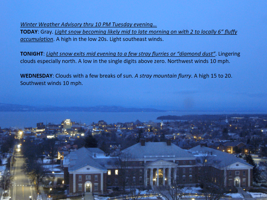
Winter Weather Advisory thru 10 PM Tuesday evening…

TODAY: Gray. Light snow becoming likely mid to late morning on with 2 to locally 6” fluffy accumulation. A high in the low 20s. Light southeast winds.

TONIGHT: Light snow exits mid evening to a few stray flurries or “diamond dust”. Lingering clouds especially north. A low in the single digits above zero. Northwest winds 10 mph.

WEDNESDAY: Clouds with a few breaks of sun. A stray mountain flurry. A high 15 to 20. Southwest winds 10 mph.

Looking further ahead

WEDNESDAY NIGHT: Variable clouds.A low ranging thru the single digits.

THURSDAY: Clouding up. Occasional lake effect flurries, with minor coatings. A high upper teens to near 20.

FRIDAY: Variable cloudiness. Scattered light flurries with minor coatings. A low 5 below to 5 above. A high 10

to 15.

SATURDAY: Overcast & gray. Chance for a flurry. A low 5 below to 5 above. A high around 10 above.

Average lows single digits. Average highs mid-20s to upper 20s

RH/1-16forecast][end]

Updated Monday Evening Forecast — January 15th, 2023

TONIGHT: Fair high cloudiness this evening, thickening up overnight with spotty light snow developing far southern areas. Seasonably cold. A low mid-single digits to around 10. Little wind.

TOMORROW: Gray. Light snow becoming likely mid to late morning on with 1 to locally 3” fluffy accumulation. A high in the mid-20s. Light southeast winds.

TUESDAY NIGHT: Light snow or snow showers exits mid evening. Lingering clouds especially north. A low in the single digits. Northwest winds 10 mph.

WEDNESDAY: Clouds with a few breaks of sun. A high 15 to 20. Southwest winds 10 mph.

Looking further ahead

WEDNESDAY NIGHT: Partly cloudy.A low mid-single digits to low teens

THURSDAY: Mostly cloudy. Scattered lake effect flurries, mainly in the mountains with minor coatings. A high upper teens to near 20.

FRIDAY: Cloudy. Slight chance for spotty flurries southern areas. A low in the single digits. A high mid to upper teens.

SATURDAY: Overcast & gray. Chance for a flurry. A low around zero to 5 above. A high around 10 above.

Average lows single digits. Average highs mid-20s to upper 20s

RH/1-15forecast][end]

Updated Monday morning forecast — January 15th, 2024

TODAY: Clouds northern areas, with a couple stray northern mountain flurries, otherwise sunshine giving way to more clouds western areas this afternoon. Slightly below normal in temperature. A high in the lower 20s. Light southwest winds.

TONIGHT: High cloudiness this evening, thickening up overnight. A low ranging in the single digits. Little wind.

TUESDAY: Gray. Light accumulating snow likely with about 1 to 2”. A high 20 to 25. Light southwest winds.

Looking further ahead

TUESDAY NIGHT: Becoming partly cloudy. A low in the single digits.

WEDNESDAY: Mixed sun and clouds. A high mid to upper teens.

THURSDAY: Mostly cloudy. Scattered lake effect flurries, mainly in the mountains. A low mid-single digits to low teens. A high upper teens.

FRIDAY: High overcast or cloudy. Slight chance for spotty flurries southern areas. A low in the single digits. A high upper teens.

Average lows single digits. Average highs mid-20s to upper 20s

RH/1-15forecast][end]

Updated Friday Evening Forecast — January 12th, 2024

High Wind Warnings & Wind Advisories 11 PM tonight thru 11 AM Saturday…worst western slopes, portions of the northern tier. Winter Weather Advisory Orange County south.

TONIGHT: Thickening clouds, leading to wet snow & a wintry mix around midnight with slick travel. Accumulation of about 1 to 3” valleys and 2 to locally 5” high terrain of the central and southern Greens Increasingly windy, & milder. An evening low near 25 with temperatures rising to near freezing overnight. Southeast winds picking up 15 to 30 mph with gusts 45 to 65 mph western slopes of the Green Mountains.

TOMORROW: A wintry mix with slick travel mid to late morning gives way to occasional light rain showers mixed with wet snowflakes. Milder. Brief intervals of sun in the afternoon. A high around 40. Southeast winds 15 to 30 mph with gusts 45 to 65 mph western slopes, shifting to southwesterly 10 to 20 mph.

SATURDAY NIGHT: Becoming mostly cloudy. Good chance for mountain snow showers & valley flurries. A low in the upper teens. Southwest winds 10 to 20 mph.

SUNDAY: Partly to mostly cloudy. Scattered lake effect snow showers with minor accumulation especially northern mountains. A high in the mid-20s. West to southwest winds 10 to occasionally 25 mph.

Looking further ahead

SUNDAY NIGHT: Clouds breaking up becoming mostly clear. A low around 10.

MONDAY: Sun mixing with clouds northern areas, otherwise mostly sunny. A high in the low 20s.

TUESDAY: Gray. Chance for snow showers or flurries…with some accumulation. A low in the low teens. A high 20 to 25.

WEDNESDAY: Partly sunny. A low about 5 to 10 above. A high in the lower 20s.

Average lows single digits. Average highs mid-20s to 30

RH/1-12forecast][end]

Updated Friday Morning Forecast — January 12th, 2024

TODAY: Clouds with a stray flurry Northeast Kingdom, otherwise morning clouds give way to partial sunshine. A high around 30 northern areas, and 32 to 35 southern areas. Light winds becoming southeasterly.

High Wind Warning 11 PM tonight thru 10 AM Saturday mainly western slopes and portions of the northern tier of Vermont…Winter Weather Advisory portions of central and southern Green Mountains.

TONIGHT: Thickening clouds, leading to wet snow & a wintry mix around midnight with slick travel. Accumulation of about 1 to 2” valleys and 2 to locally 5” southern Green Mountains. Becoming windy, & milder. An evening low near 25 with temperatures rising to near freezing overnight. Southeast winds picking up 15 to 30 mph with gusts 45 to 65 mph western slopes of the Green Mountains.

SATURDAY: A wintry mix with slick travel early, gives way to occasional light rain shower activity mixed with wet snowflakes. Milder. Brief intervals of sun in the afternoon. A high around 40. Southeast winds 15 to 30 mph with gusts 45 to 65 mph western slopes, shifting to southwesterly 10 to 20 mph.

Looking further ahead

SATURDAY NIGHT: Becoming mostly cloudy. Good chance for mountain snow showers & valley flurries. A low in the upper teens.

SUNDAY: Partly to mostly cloudy. Scattered lake effect snow showers with minor accumulation especially northern mountains. A high in the mid-20s.

MONDAY: Clouds and sun northern areas, & partly to mostly sunny central and south. A low around 10. A high in the low 20s.

TUESDAY: Gray. Chance for snow showers or flurries…with some accumulation. A low in the low teens. A high 20 to 25.

WEDNESDAY: Mostly cloudy. A low about 5 to 10 above. A high in the lower 20s.

Average lows single digits. Average highs mid-20s to 30

RH/1-11forecast][end]

Updated Thursday Evening Forecast — January 11th, 2023

TONIGHT: Considerable cloudiness. Leftover flurries with a dusting to less than an inch. A low in the lower 20s. Light west winds.

TOMORROW: The pick.Morning clouds give way to partly to mostly sunny skies. A high near 30. Light winds becoming southeasterly.

High Wind Watch Friday night into Saturday morning…

FRIDAY NIGHT: Thickening clouds, leading to wet snow & a wintry mix around midnight with slick travel. Accumulation of about 1 to locally 4”. Increasingly windy, & turning milder. An evening low near 25 with temperatures rising to near freezing overnight. Southeast winds picking up 15 to 30 mph with gusts exceeding 45 mph western slopes of the Green Mountains.

SATURDAY: A wintry mix with slick travel early, gives way to occasional light rain shower activity mixed with wet snowflakes. Milder. Brief intervals of sun in the afternoon. A high in the low 40s. Southeast winds 15 to 30 mph gusts over 45 mph western slopes, shifting to southwesterly 10 to 20 mph.

Looking further ahead

SATURDAY NIGHT: Becoming mostly cloudy. Good chance for mountain snow showers & valley flurries. A low in the upper teens.

SUNDAY: Partly to mostly cloudy. Scattered lake effect snow showers with minor accumulation especially northern mountains. A high around 30.

MONDAY: Mostly cloudy northern areas. Partly sunny south. A low 10 to 15. A high 20 to 25.

TUESDAY: Considerable cloudiness. Scattered mountain flurries with just a skiff of snow. A low in the teens. A high in the lower 20s.

Average lows single digits. Average highs mid-20s to 30

RH/1-11forecast][end]