Updated Tuesday Evening Forecast — December 20th, 2016

TONIGHT: Partly cloudy.A low in the upper teens. South winds about 10 mph.

Winter Solstice 5:44 AM Wednesday morning…

TOMORROW: Partly to mostly cloudy. Widely scattered flurries near Quebec border. A high near 35. West to southwest winds 10 to 20 mph.

WEDNESDAY NIGHT: Increasing clouds. A rising chance for light snow arriving toward daybreak. A low 20 to 25. Light south winds.

THURSDAY: Gray. Periods of light snow with accumulations of 1 to 2 “ valley floors up to locally 4” with most in the higher terrain. A high near 32. South winds 10 to 15 mph.

Looking Further ahead…

THURSDAY NIGHT: Scattered northern mountain snow showers and valley flurries. A low near 25.

FRIDAY: Leftover flurries Northeast kingdom or northern tier. Blustery. Partial afternoon sunshine. A high in the mid 30s.

SATURDAY: Morning sun then clouding up. Chance for flurries or mountain snow showers. A low in the upper teens. A high 35 to 40.

SUNDAY CHRISTMAS DAY: Partly cloudy. Slight chance for a morning flurry. A low near 30. A high in the mid 30s.

MONDAY: Increasing clouds. Chance for scattered snow showers. A low near 10. A high in the 20s.

TUESDAY: Chance for snow or mixed precipitation. A low in the mid 20s. A high 45 to 50.

Average lows 10 to 15. Normal highs upper 20s to low 30s.

RH/12-20[end]

Updated Tuesday morning Forecast & WX Notes — December 20th, 2016

· First off when politics and Climate and Weather collide – this is chilling

· High pressure today brings great weather though with the cold arctic start outside of the Champlain Valley…See below –

· Overnight modeling now showing about 1 to locally 3” of snowfall beginning around or before daybreak Thursday morning likely affecting travel, but very welcome ahead of the Christmas Holiday this weekend.

· Milder air gradually intrudes with a big push to cause our next rainstorm and melt-back Tuesday.

TODAY: Mostly sunny with high clouds. A high in the mid 20s. South winds 10 mph.

TONIGHT: Partly cloudy.A low in the low 20s. South winds about 10 mph.

Winter Solstice 5:44 AM Wednesday morning…

WEDNESDAY: Partly to mostly cloudy. Isolated flurries near Quebec border in the afternoon. A high in the low 30s. West winds 10 to 20 mph.

Looking Further ahead…

WEDNESDAY NIGHT: Increasing clouds. A rising chance for light snow arriving toward daybreak. A low 20 to 25.

THURSDAY: Gray. Periods of light snow with accumulations of 1 to locally 3” with most in the higher terrain. A high near 32.

FRIDAY: Leftover flurries near the mountains early and blustery. Partial afternoon sunshine. A low 20 to 25. A high in the mid 30s.

SATURDAY: Morning sun then clouding up. Chance for flurries or mountain snow showers. A low 20 to 25. A high 35 to 40.

SUNDAY CHRISTMAS DAY: Partly cloudy. Slight chance for a morning flurry. A low 25 to 30. A high around 35.

MONDAY: Variable high clouds. A low 10 to 15. A high around 40.

Average lows 10 to 15. Normal highs upper 20s to low 30s.

RH/12-20[end]

Updated Monday Evening forecast — December 19th, 2016

TONIGHT: Clear and frigid. A low around zero to 5 below. Light south winds.

TOMORROW: Mostly sunny with high clouds. A high in the mid 20s. South winds 10 mph.

TUESDAY NIGHT: Partly cloudy.A low in the low 20s. South winds about 10 mph.

Winter Solstice 5:44 AM Wednesday morning…

WEDNESDAY: Partly to mostly cloudy. Isolated flurries near Quebec border in the afternoon. A high in the upper 20s to around 30. West winds 10 to 20 mph.

Looking Further ahead…

WEDNESDAY NIGHT: Scattered clouds. A low around 25.

THURSDAY: Gray. Chance for light snow showers or flurries some minor accumulations northern mountain areas. A high in the mid 30s.

FRIDAY: Lots of clouds, Partial sunshine in the afternoon. Scattered leftover mountain flurries. A low in the mid 20s. A high in the mid 30s.

SATURDAY: Morning sun becoming filtered through high cloudiness. A low near 20. A high in the low 40s.

SUNDAY CHRISTMAS DAY: Partly cloudy. Slight chance for a flurry. A low 25 to 30. A high around 40.

Average lows 10 to 15. Normal highs upper 20s to low 30s.

RH/12-19[end]

Updated Monday morning Forecast & WX Notes —

· Nice calm but cold weather next couple of days.

· High clouds blow in aloft dimming the sunshine some Tuesday afternoon.

· Expect partly to mostly cloudy weather Wednesday introduction of some flurries northern areas as a weak weather system tracks well north of us in Quebec.

· Jet stream energy develops low pressure over the Great Lakes region and pushes east into N. Vermont Thursday good for some light accumulating snows and likely some slicker travel.

· This jet stream energy also come with milder Pacific type air = warmer conditions not arctic.

· The big energy develops across the Pacific and slams the Pacific NW. This pattern favors seasonable to milder than normal conditions going into the Christmas Holiday weekend.

· True meteorological winter (by definition the coldest 90 days of winter) started a week ago last Monday the 12th.

· End of Meteorological Winter March 9th Midpoint of winter (Jan. Thaw is January 23rd)

TODAY: Sunny but cold. A high 10 to 15. Little wind.

TONIGHT: Clear and frigid. A low zero to 10 below. Light south winds.

TUESDAY: Mostly sunny with high clouds. A high in the mid 20s. South winds 10 mph.

Looking Further ahead…

TUESDAY NIGHT: Partly to mostly cloudy.A low near 20.

Winter Solstice 5:44 AM Wednesday morning…

WEDNESDAY: Partly to mostly cloudy. Scattered flurries developing Barre-Montpelier area north. A high near 25.

THURSDAY: Gray. Chance for periods of light accumulating snow. A low 20 to 25. A high in the low to mid 30s.

FRIDAY: Partly cloudy in the morning giving way to more sun in the afternoon. A low in the mid 20s. A high in the mid 30s.

SATURDAY: Morning sun becoming filtered through high cloudiness. A low 15 to 20. A high around 40.

Average lows 10 to 15. Normal highs upper 20s to low 30s.

RH/12-19[end]

Updated Friday Evening Forecast — December 16th, 2016

Winter Weather Advisory Saturday morning through Sunday morning

TONIGHT: Fair this evening, then clouding up. Light snow developing after midnight and before daybreak. Temperatures 0 to 15. Light south winds.

TOMORROW: Gray. Periods of light snow…moderate at times tapering off to flurries in the afternoon. Total accumulations of about 2 to 4” but locally more toward Rutland. A late day high 30 to 35 degrees.Southeast winds 10 to 20 mph.

SATURDAY NIGHT: Overcast. Occasional light rain with pockets of freezing rain & light glazing redeveloping late evening on. Temperatures rising overnight through the 30s. Gusty south to southeasterly winds 10 to 25 mph across hills.

SUNDAY: Gray. Rain possibly moderate at times in the morning… tapering off to scattered sprinkles with a few wet snow flakes. A high in the mid to upper 40s. Southwest winds 10 to 20 mph becoming westerly in the afternoon.

Looking Further ahead…

SUNDAY NIGHT: Partial clearing, blustery and turning colder. A low zero to 10 below.

MONDAY: Morning clouds then mostly sunny and cold.. A high 10 to 15.

TUESDAY: Mostly sunny with high clouds. A low zero to 10 below. A high in the mid 20s.

Winter Solstice 5:44 AM Wednesday morning…

WEDNESDAY: Partly to mostly cloudy. Chance for a flurry. A low 20 to 25. A high in the mid 30s.

THURSDAY: Gray. Chance for snow. A low 20 to 25. A high around 30.

Average lows in the low to mid teens. Normal highs low 30s.

RH/12-16[end]

Updated Friday Morning forecast & WX Notes — December 16th, 2016

· A slew of weather continues to affect our region as jet stream energy brings winds, cold, snow warmth, treacherous travel periods and eventually rain before we recycle back to lows going below zero all between now and Sunday night Geesh!

· See “period by period” below for all details.

· Expect nasty travel especially late Saturday into early Sunday morning.

Wind Chill Warnings/Advisories through 11 AM this morning…

TODAY: Scattered diamond dust flurries this morning, Otherwise lots of sunshine. Frigid. A high around 10 above. West winds 10 to 15 mph with very low wind chills…gradually diminishing.

TONIGHT: Increasing and thickening clouds. Light snow developing after midnight and before daybreak. A low around 10. Light south winds.

SATURDAY: Gray. Periods of light snow…moderate for a time in the morning. Occasional light snow or flurries in the afternoon. Total accumulations of 2 to 4” but locally more toward southern Vermont. A late high reaching 30 to 35 degrees.Southeast winds 10 to 20 mph.

Looking Further ahead…

SATURDAY NIGHT: Potential for treacherous travel! Occasional light rain with pockets of freezing rain with light glazing. Poor travel of back gravel roads with an occasional rain shower. Temperatures rising overnight through the 30s. Gusty south to southeasterly winds 10 to 25 mph across hills.

SUNDAY: Gray. Rain possibly moderate at times in the morning… tapering off to scattered sprinkles with a few wet snow flakes. A high in the mid to upper 40s.

MONDAY: Mostly sunny and cold. A low zero to 10 below. A high 10 to 15.

TUESDAY: Mostly sunny with high clouds. A low zero to 10 below. A high in the mid 20s.

WEDNESDAY: Partly to mostly cloudy. Chance for a flurry. A low around 20. A high in the mid 30s.

THURSDAY: Gray and cloudy. Chance for snow, possible mixed precipitation. Temperatures around 30.

Average lows in the low to mid teens. Normal highs low 30s.

RH/12-15[end]

Updated Thursday Night Forecast — December 15th, 2016

Wind Chill Warnings/Advisories through 11 AM Friday morning…

TONIGHT: Variably cloudy. Scattered flurries with a chance for a snow squall or two. A low 5 to 10 below. Northwest winds 10 to 25 mph with gusts to 40 mph accompanied by dangerous wind chills as low 35 below.

TOMORROW: Lots of sunshine. Frigid. A high around 10 above. West winds 10 to 15 mph with very low wind chills…gradually diminishing.

FRIDAY NIGHT: Increasing and thickening clouds. Light snow developing after midnight. A low around 10. Light south winds.

SATURDAY: Gray. Periods of snow likely…moderate at times snow, transitioning to mixed precipitation late. Accumulations of about 2 to locally 5”. A high in the upper 30s late in the day. Southeast winds 10 to 15 mph.

Looking Further ahead…

SATURDAY NIGHT: Treacherous travel developing light mixtures of precipitation eventually changing to rain overnight. A low near 35. Southeast winds 10 to 20 mph.

SUNDAY: Gray. Chance for freezing rain with treacherous travel early. Rain… moderate at times in the afternoon changing back to scattered snow showers. A high in the 40s.

MONDAY: Mostly sunny and cold. A low zero to 10 below. A high 10 to 15.

TUESDAY: Mostly sunny with high clouds. A low around zero. A high in the mid 20s.

Updated Thursday morning Forecast & WX Notes — December 15th, 2016

· Boat loads of weather coming at us: Arctic chill combines with strong gusty winds…exceeding 40 mph in spots capable of tree limb damage and isolated power outages which could be unpleasant combo.

· Winds fall off gradually later overnight Friday morning but wind chills continue into the morning tomorrow – some buses may not be running, with dangerous wind chills parents should alternative plans tomorrow morning for the busses.

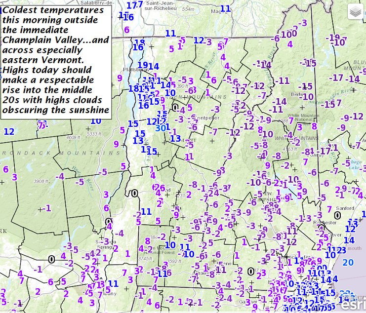
· Break in the action with cold arctic high pressure bringing us decent but very cold Friday.

· Snow pushes in for the weekend late Friday night/Saturday with some decent amounts 4 to locally 7 8” possible S. VT and about 2 to 5” far northern areas.

· Second wave pushes in Saturday night with warm transitions making for “treacherous travel Saturday night into Sunday morning before temps aloft and at the surface make a huge warm up…through the 30s with warm air advection ending late Sunday into the 40s to near50!!!

· Drastic Falls in temperature along with strong gusty winds and more lowered wind chills Sunday night into the morning Monday.

Wind Chill Warnings/Advisories for 4 PM late today through 11 AM Friday morning…

TODAY: Variably cloudy & increasingly blustery. Flurries… with a risk for heavier snow squalls. Accumulations of a dusting to 2”. A high in the low to mid teens. Northwest winds pick up at 10 to 25 mph with higher gusts making for dangerous wind chills.

TONIGHT: Variably cloudy. Scattered flurries with a chance for a snow squall or two. A low 5 to 10 below. Northwest winds 10 to 25 mph with gusts to 40 mph accompanied by dangerous wind chills as low 35 below.

FRIDAY: Arctic-like sunshine. Maybe a diamond dust flurry. A high just 5 to 10 above. West winds 10 to 15 mph with very low wind chills…gradually diminishing.

Looking Further ahead…

FRIDAY NIGHT: Increasing and thickening clouds leading to a chance for light snow toward daybreak. A low in the single digits.

SATURDAY: Gray. Periods of snow likely…moderate at times snow, transitioning to mixed precipitation late. Accumulations of about 2 to locally 5”. A high near 30 late in the day.

SATURDAY NIGHT: Treacherous travel developing light mixtures of precipitation eventually changing to rain overnight. A low in the low 30s. Southeast winds 10 to 20 mph.

SUNDAY: Gray. Chance for freezing rain with treacherous travel in the morning transitioning to rain moderate at times. A high in the upper 30s to upper 40s.

MONDAY: Mostly sunny and cold. A low zero to 10 below. A high around 15.

Average lows in the low to mid teens. Normal highs low 30s.

RH/12-15[end]

Updated Wednesday Evening forecast — December 14th, 2016

TONIGHT: Lots of clouds. Occasional accumulating snow showers. A dusting to locally 3” fluffy accumulation. A low in the single digits. Southwest winds 10 to 15 mph.

Wind Chill Warning Late Thursday into Friday morning…

TOMORROW: Variably cloudy & increasingly blustery. Chance for flurries with a risk of heavier snow squalls. A dusting to locally 3”. A high in the low to mid teens. Northwest winds pick up at 10 to 25 mph. with higher gusts making for dangerous wind chills as low as 35 below.

THURSDAY NIGHT: Variably cloudy. Scattered flurries with a chance for a snow squall or two. A low 5 to 10 below. Northwest winds 10 to 25 mph with gusts to 40 mph accompanied by dangerous wind chills.

FRIDAY: Arctic-like sunshine. Maybe a diamond dust flurry. A high just 5 to 10 above. South winds around 10 mph.

Looking Further ahead…

FRIDAY NIGHT: Increasing and thickening clouds leading to a chance for light snow toward daybreak. A low zero to 10 degrees above.

SATURDAY: Gray. Chance for light to moderate snow, transitioning to mixed precipitation late in the day. Accumulations of about 2 to locally 5”. A high reaching the low 30s late in the day. Treacherous travel developing Saturday night with light mixtures of precipitation eventually changing to all rain overnight. Southeast winds 10 to 20 mph.

SUNDAY: Gray. Chance for freezing rain with treacherous travel possible transitioning to rain moderate at times.. A low in the low 30s. A high in the upper 30s to low 40s.

MONDAY: Mostly sunny and cold. A low zero to 10 below. A high around 15.

Average lows in the mid teens. Normal highs 30 to 35.

RH/12-12[end]

Updated Wednesday morning Forecast & WX notes — December 14th, 2016

· Lake enhanced snow bands were tracking through portions of mainly northern Vermont this morning…they should decrease to scattered flurries.

· More snow coated roads were expected tonight as progressively colder air works over the relatively warm water of the Great Lakes producing another round of a dusting to 3” amounts.

· Snow squalls/flurries continue off and on with the coldest air so far this season reaching into Vermont Thursday night and Friday Wind Chill Watch along and east of the N. Green Mountains with potential strong gusty winds and power outages.

· Cold arctic chill day but with blue skies Friday.

· High pressure pulls away with big warm up on the way for the weekend bringing snow Saturday and transitions to rain Sunday.

THIS MORNING:Snow showers tapering off to flurries mainly northern areas. A dusting to an inch of accumulation making for slick travel – please slow down and drive the conditions. Temperatures falling into the mid 20s.West to southwest winds 10 mph.

THIS AFTERNOON: A few stray flurries mixing with intervals of sun later on . A Temperatures in the mid 20s. Southwest winds 10 to 15 mph.

TONIGHT: Lots of clouds. Occasional accumulating snow showers. A dusting to locally 3” fluffy accumulation. A low in the single digits. Southwest winds 10 to 15 mph.

Wind Chill Watch Thursday Afternoon thru Friday morning…

THURSDAY: Variably cloudy & increasingly blustery. Chance for flurries with a risk of heavier snow squalls. A dusting to locally 3”. A high in the low to mid teens. Northwest winds pick up at 10 to 25 mph. with higher gusts making for dangerous wind chills.

Looking Further ahead…

THURSDAY NIGHT: Variably cloudy. Scattered flurries with a chance for a snow squall or two. A low 5 to 10 below accompanied by dangerous wind chills.

FRIDAY: Arctic-like sunshine. Maybe a diamond dust flurry. A high just 5 to 10 above.

SATURDAY: Gray. Chance for snow or mixed precipitation, possibly significant with poor travel. A low zero to 10 above. A high in the mid to upper 30s.

SUNDAY: Gray. Chance for freezing rain with treacherous travel possible transitioning to rain moderate at times.. A low in the low 30s. A high in the upper 30s to low 40s.

Average lows in the mid teens. Normal highs 30 to 35.

RH/12-12[end]