
· First off when politics and Climate and Weather collide – this is chilling…
· High pressure today brings great weather though with the cold arctic start outside of the Champlain Valley…See below – 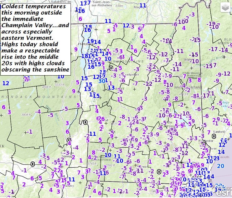
· Overnight modeling now showing about 1 to locally 3” of snowfall beginning around or before daybreak Thursday morning likely affecting travel, but very welcome ahead of the Christmas Holiday this weekend.
· Milder air gradually intrudes with a big push to cause our next rainstorm and melt-back Tuesday.
TODAY: Mostly sunny with high clouds. A high in the mid 20s. South winds 10 mph.
TONIGHT: Partly cloudy.A low in the low 20s. South winds about 10 mph.
Winter Solstice 5:44 AM Wednesday morning…
WEDNESDAY: Partly to mostly cloudy. Isolated flurries near Quebec border in the afternoon. A high in the low 30s. West winds 10 to 20 mph.
Looking Further ahead…
WEDNESDAY NIGHT: Increasing clouds. A rising chance for light snow arriving toward daybreak. A low 20 to 25.
THURSDAY: Gray. Periods of light snow with accumulations of 1 to locally 3” with most in the higher terrain. A high near 32.
FRIDAY: Leftover flurries near the mountains early and blustery. Partial afternoon sunshine. A low 20 to 25. A high in the mid 30s.
SATURDAY: Morning sun then clouding up. Chance for flurries or mountain snow showers. A low 20 to 25. A high 35 to 40.
SUNDAY CHRISTMAS DAY: Partly cloudy. Slight chance for a morning flurry. A low 25 to 30. A high around 35.
MONDAY: Variable high clouds. A low 10 to 15. A high around 40.
Average lows 10 to 15. Normal highs upper 20s to low 30s.
RH/12-20[end]
