Updated Tuesday Morning Forecast — February 25th, 2020

TODAY: Clouds with a few intervals of sun. A few brief rain showers or sprinkles this afternoon. A high in the low to mid 40s. Light north winds.

TONIGHT: Overcast. Accumulating wet snow showers mixed with rain. Minor slushy accumulation overnight. A low upper 20s to low 30s. Light northeast winds.

WEDNESDAY: Gray. Occasional wet snow…mixed with rain valley floors. Minor accumulation higher terrain. A high 35 to 40. Light east winds.

Looking further ahead…

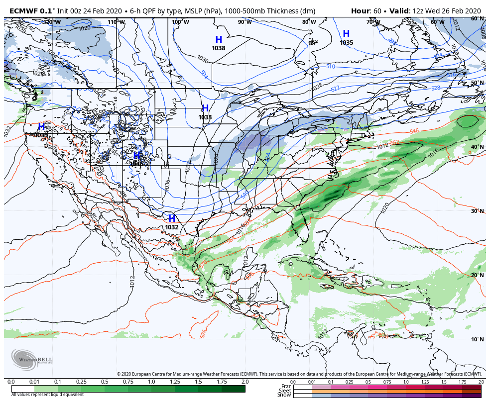
Winter Storm Watch – Wednesday Evening thru Thursday afternoon

WEDNESDAY NIGHT: Cloudy. Periods of wet snow, mixed with rain valley floors. Blustery to windy especially western slopes of the Green Mountains overnight. A low 32 to 35 degrees.

THURSDAY: Cloudy. Periods of accumulating wet snow mixed with rain lower valleys. A couple to several inches possible especially elevated terrain. Blustery to windy in the morning. A high in the mid to upper 30s.

FRIDAY: Lots of clouds, but some intervals of sun. Scattered snow showers with some minor accumulation in the mountains. A low in the mid to upper teens. A high 25 to 30.

SATURDAY: Chance for a mountain snow shower/valley flurry. Minimal accumulation. Otherwise partly sunny in the afternoon. A low around 10 above. A high around 25.

SUNDAY: More sun than clouds. A low zero to 10 below. A high 20 to 25.

Average lows in the teens, average highs in the 30s….

RH/2-25[end]

Updated Monday Evening Forecast — February 24th, 2020

TONIGHT: Thickening clouds. A low in the low 30s east of the Greens 32 to 35 western areas. Little wind.

TOMORROW: Clouds with a few intervals of sun. Maybe a brief sprinkle late. A high in the low 40s. Light north winds.

TUESDAY NIGHT: Overcast. Rising chance for accumulating wet snow showers. Some minor slushy accumulation. A low upper 20s to low 30s. Light northeast winds.

WEDNESDAY: Gray. Chance for periods of wet snow mixed with rain. A high mid to upper 30s. Light east winds.

Looking further ahead…

WEDNESDAY NIGHT: Cloudy. Scattered wet snow showers. A low near 30.

THURSDAY: Cloudy. Periods of accumulating wet snow, a few to several inches possible. Blustery to windy especially western slopes of the Green Mountains. A high in the mid to upper 30s.

FRIDAY: Lots of clouds, but some intervals of sun. Scattered snow showers with some minor accumulation in the mountains. A low in the mid to upper teens. A high 25 to 30.

SATURDAY: Considerable cloudiness. Scattered mountain snow showers and valley flurries. Minor accumulation. A low around 10 above. A high around 25.

SUNDAY: Widely scattered mountain snow showers and flurries. Otherwise mixed sun and clouds. A low zero to 10 below. A high 20 to 25.

Average lows in the teens, average highs in the 30s….

RH/2-24[end]

Updated Monday morning Forecast — February 24th, 2020

TODAY: Morning sunshine becomes filtered through high cloudiness. Temperatures running 15 to 20 degrees above seasonal norms with a good chance for “sap runs”. A high mid-40s pushing near 50. Southwest winds 10 mph.

TONIGHT: Thickening clouds. A low 30 to 35. Little wind.

TUESDAY: Clouds with a few intervals of sun. A high in the low 40s. Light north winds.

Looking further ahead…

TUESDAY NIGHT: Overcast. Rising chance for accumulating wet snow showers. Some minor accumulation. A low upper 20s to low 30s.

WEDNESDAY: Gray. Chance for periods of wet snow mixed with rain especially valley floors. A high upper 30s.

THURSDAY: Cloudy. Periods of accumulating wet snow, a few to several inches possible. Blustery to windy especially western slopes of the Green Mountains. A low 25 to 30. A high around 35.

FRIDAY: Lots of clouds, but some intervals of sun later on. Scattered snow showers with some minor accumulation northern areas. A low in the mid to upper teens. A high mid-20s to around 30.

SATURDAY: Considerable cloudiness with scattered snow showers and valley flurries. A low around 10 above. A high around 25.

Average lows in the teens, average highs in the 30s….

RH/2-21[end]

Updated Friday Evening Forecast — February 21st, 2020

TONIGHT: Mostly clear with a few more clouds late. A low around 10 to 15 above. Light south to southwest winds stronger near Lake Champlain.

TOMORROW: Sunshine mixed with high cloudiness. Milder. A high near 35. Southwest winds 10 mph.

SATURDAY NIGHT: A few high clouds otherwise clear but not as cold. A low in the mid-teens. Light southwest winds.

SUNDAY: Variable high clouds but lots of sun. Possible Sap run. A high in the low 40s. Light and southwesterly.

Looking further ahead…

SUNDAY NIGHT: Mostly clear. A low upper teens to low 20s.

MONDAY: Partly to mostly sunny. Above normal in temperature with a sap run possible. A high in the mid-40s.

TUESDAY: Considerable cloudiness. Rising chance for light snow or mixed precipitation toward evening. A low in the 20s. A high 35 to 40.

WEDNESDAY: Mainly cloudy. Chance for snow or mixed precip. A low 25 to 30. A high around 35.

Average lows low to mid-teens, average highs low to mid-30s.

RH/2-21[end]

Updated Friday morning Forecast — February 21st, 2020

TODAY: Sunny but chilly. A high 20 to 25. Light southwest winds…stronger toward Lake Champlain this afternoon.

TONIGHT: A few high clouds. A low around 10 to 15 above. Light south to southwest winds stronger near Lake Champlain.

SATURDAY: Sunshine filtered through high clouds. Milder. A high around 35. Southwest winds 10 mph.

Looking further ahead…

SATURDAY NIGHT: A few high clouds otherwise clear but not as cold. A low 15 to 20.

SUNDAY: Sunny. Possible Sap run. A high near 40 degrees.

MONDAY: Sunshine gives way to considerable high cloudiness. A low mid-teens to low 20s. Above normal in temperature with a sap run possible. A high in the mid 40s.

TUESDAY: Gray. Spotty light rain with a risk for freezing rain in the morning. A low around 32. A high in the mid-40s.

WEDNESDAY: Mainly cloudy. A rising chance for rain or mixed precipitation. A low around 32. A high in the mid to upper 30s.

Average lows low to mid teens, average highs low to mid-30s.

RH/2-20[end]

Updated Thursday Evening Forecast — February 20th, 2020

TONIGHT: Clear and frigid. A low 5 to 10 below. Little wind.

TOMORROW: Sunny but chilly. A high 20 to 25. Light southwest winds…stronger toward Lake Champlain.

FRIDAY NIGHT: A few high clouds. A low around 10 to 15 above. Light south to southwest winds stronger near Lake Champlain.

SATURDAY: Sunshine filtered through high clouds. Milder. A high around 35. Southwest winds 10 mph.

Looking further ahead…

SATURDAY NIGHT: A low 15 to 20.

SUNDAY: Sunny. Possible Sap run. A high near 40 degrees.

MONDAY: Sunshine gives way to considerable high cloudiness. A low mid-teens to low 20s. Above normal in temperature with a sap run possible. A high pushing to near 45.

TUESDAY: Gray. Spotty light rain with a risk for freezing rain in the morning. A low around 32. A high in the mid-40s.

WEDNESDAY: Mainly cloudy. A rising chance for rain or mixed precipitation. A low around 32. A high 40 to 45.

Average lows upper single digits to mid-teens, average highs low to mid-30s.

RH/2-20[end]

Updated Thursday Morning Forecast — February 20th, 2020

TODAY: More clouds push in with few stray flurries through about mid-day. More sunshine this afternoon. Cold. A high in the mid to upper teens. Northwest winds 10 mph.

TONIGHT: Clear and frigid. A low 5 to 10 below. Light winds.

FRIDAY: Sunny but chilly. A high 20 to 25. Light southwest winds…stronger toward Lake Champlain.

Looking further ahead…

FRIDAY NIGHT: A few high clouds. A low around 10 to 15 above.

SATURDAY: Partly to mostly sunny and milder. A high around 35.

SUNDAY: Sunny. A low 15 to 20. Possible Sap run. A high near 40 degrees.

MONDAY: Sunshine gives way to thickening clouds. A low mid-teens to low 20s. A sap run possible with a high near 45.

TUESDAY: Gray. Chance for rain moderate at times mixed with wet snow flakes higher summits. Risk for freezing rain at onset. A low around 30. A high in the mid-40s.

Average lows upper single digits to mid-teens, average highs low to mid-30s.

RH/2-20[end]

Updated Wednesday Evening Forecast — February 19th 2020

TONIGHT: Scattered clouds and colder. A low 5 below to 5 above. Light northwest winds.

TOMORROW: Partly sunny. A high low to mid-teens. Northwest winds 10 mph.

THURSDAY NIGHT: Clear and frigid. A low 5 to 15 below. Light winds.

FRIDAY: Sunny but cold. A high 20 to 25. Light southwest winds…stronger toward Lake Champlain.

Looking further ahead…

FRIDAY NIGHT: A few high clouds. A low around 10 to 15 above

SATURDAY: Partly to mostly sunny and milder. A high mid to upper 30s.

SUNDAY: Sunny. A low 15 to 20. Possible Sap run. A high near 40 degrees.

MONDAY: Sunshine gives way to thickening clouds. A low mid teens to low 20s. A sap run possible with a high near 45.

TUESDAY: Gray. Chance for rain moderate at times mixed with wet snow flakes higher summits. Risk for freezing rain at onset. A low mid to upper 20s. A high around 45.

Average lows upper single digits to mid-teens, average highs low to mid-30s.

RH/2-19[end]

Updated Wednesday Morning Forecast — February 19th, 2020

TODAY: Mostly cloudy with scattered flurries north of the Barre-Montpelier area thru late morning. Clouds mixed with periods of sun central and southern areas. Blustery. Early high 30 to 35 this morning, but falling through the 20s this afternoon. West to northwesterly winds flare up at 10 to 25 mph and gusty.

TONIGHT: Partly cloudy. Chance for a few stray mountain flurries. A low around 5 above. Light northwest winds.

THURSDAY: Scattered flurries, then partial or better afternoon sunshine. A high around 15. Northwest winds 10 mph.

Looking further ahead…

THURSDAY NIGHT: Mostly clear. A low zero to 10 below.

FRIDAY: Sunny but cold. A high near 20.

SATURDAY: A few morning clouds then mostly sunny and milder. A low around 10 above. A high in the mid-30s.

SUNDAY: Sunshine with a few high clouds. A low 15 to 20. Possible Sap run. A high near 40 degrees.

MONDAY: Filtered morning sun, then clouding up. Chance for rain with a possible wintry mix at onset. A low 20 to 25. A sap run possible with a high near 45.

Average lows upper single digits to mid-teens, average highs low to mid-30s.

RH/2-19[end]

Updated Tuesday Evening Forecast — February 18th, 2020

TONIGHT: Mixed snow, sleet and rain showers this evening exiting around midnight. Accumulation under an inch. Watch for slick icy travel. Otherwise mostly cloudy. Mild this evening, then colder overnight with a low in the mid to upper 20s. Southwest winds 10 to 20 mph shifting to northwesterly overnight.

TOMORROW: Scattered flurries near the northern border through mid-day, otherwise more clouds than sun. Blustery. Temperatures in the low to mid 20s. West to northwesterly winds flare up at 10 to 25 mph.

WEDNESDAY NIGHT: Partly cloudy. Chance for a few stray mountain flurries. A low around 5 above. Light northwest winds.

THURSDAY: Scattered flurries, then partial or better afternoon sunshine. A high around 15. Northwest winds 10 mph.

Looking further ahead…

THURSDAY NIGHT: Mostly clear. A low zero to 10 below.

FRIDAY: Sunny but cold. A high near 20.

SATURDAY: Mostly sunny and milder. A low around 10 above. A high in the mid-30s.

SUNDAY: Partly to mostly sunny. A low 15 to 20. A high near 40 degrees.

Average lows upper single digits to mid-teens, average highs low to mid-30s.

RH/2-18[end]