Updated Thursday Morning Forecast — November 16th, 2023

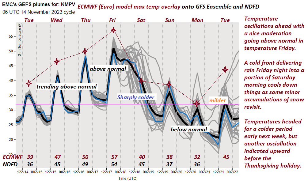
TODAY: Bright sunshine with high clouds in the afternoon. A high near 50. Light west winds.

TONIGHT: Mostly clear with a couple high clouds. A low around 32. Light south winds, stronger near Lake Champlain.

FRIDAY: Filtered sunshine to thickening clouds late. A high reaching into the mid-50s. South breeze 10 to 15 mph.

Looking further ahead

FRIDAY NIGHT: Overcast. A period of rain or showers becoming likely, moderate at times. A low 40 to 45.

SATURDAY: Morning rain showers mixing with wet snow, Blustery and sharply colder, with intervals of afternoon sunshine. Temperatures falling thru the 30s.

SUNDAY: Clouds with intervals of sun. Scattered snow showers or flurries with minor coatings. A low 20 to 25. A high mid to upper 30s.

MONDAY: Some clouds in northern areas early, then sunny. A low 20 to 25. A high of about 32 degrees.

TUESDAY: Increasingly cloudy & becoming breezy. Rising chance for accumulating wet snow & mixed precipitation. A low around 30. A high mid to upper 30s.

WEDNESDAY: Chance for rain or wet snow showers giving way to periods of sunshine. A low 25 to 30. A high in the low to mid-40s.

Average lows are mid-20s to 30. Average highs low to mid-40s

RH/11-16 forecast][end]

Updated Wednesday Evening Forecast — November 15th, 2023

TONIGHT: Some cloudiness early, with a sprinkle Quebec border, then clear skies.A low in the lower 30s. Light southwest winds.

TOMORROW: Bright sunshine with a high clouds in the afternoon. A high near 50. Light west winds.

THURSDAY NIGHT: Mostly clear with a couple high clouds. A low around 32. Light south winds, stronger near Lake Champlain.

FRIDAY: Filtered sunshine to thickening clouds late. A high reaching into the mid-50s. South breeze 10 to 15 mph.

Looking further ahead

FRIDAY NIGHT: Overcast. A period of rain or showers likely, moderate at times beginning early. A low in the low 40s.

SATURDAY: Morning rain showers mixing with wet snow, Blustery and sharply colder, with intervals of afternoon sunshine. Temperatures falling thru the 30s.

SUNDAY: Clouds with intervals of sun. Scattered snow showers or flurries with minor coatings. A low 20 to 25. A high mid to upper 30s.

MONDAY: Partly cloudy northern areas early, then lots of sunshine. A low 20 to 25. A high about 32 degrees.

Average lows mid-20s to 30. Average highs low to mid 40s

RH/11-15 forecast][end]

Updated Wednesday Morning Forecast — November 15th, 2023

TODAY: Sunshine filtered through high clouds, thickening at times this afternoon. A high near 45. South winds 10 mph, stronger near Lake Champlain.

TONIGHT: Partly cloudy.An isolated sprinkle near the Quebec border later this evening. A low 32 to 35. Light southwest winds.

THURSDAY: Sunshine filtered by high clouds. A high 45 to 50. Light west winds.

Looking further ahead

THURSDAY NIGHT: Mostly clear. A low around 30.

FRIDAY: Filtered sunshine thickening clouds late. A high reaching into the mid-50s. 

SATURDAY: Widely scattered mountain flurries. Blustery and colder, with intervals of afternoon sunshine. Temperatures fall from the low 40s in the morning into the mid and upper 30s.

SUNDAY: Clouds with intervals of sun. Widely scattered flurries with minor coatings. A low 20 to 25. A high near 35.

MONDAY: Partly cloudy northern areas early, then lots of sunshine. A low in the low to mid-20s. A high near 32 degrees.

Average lows are mid-20s to 30. Average highs low to mid-40s

RH/11-15 forecast][end]

Updated Tuesday evening Forecast — November 14th, 2023

TONIGHT: Evening clouds followed by partial clearing later overnight. A low in the mid to upper 20s. Light west to southwest winds.

TOMORROW: Sunshine filtered thru high clouds, thickening at times in the afternoon. A high near 45. South winds 10 mph, stronger near Lake Champlain.

WEDNESDAY NIGHT: Partly cloudy.Chance for a sprinkle in northern areas. Watch for icy spots. A low in the low 30s. Light southwest winds.

THURSDAY: Some northern cloudiness, otherwise sunshine filtered by high clouds. A high in the upper 40s to near 50. Light west winds.

Looking further ahead

THURSDAY NIGHT: Mostly clear. A low ranging upper 20s to mid-30s.

FRIDAY: Filtered sunshine thickening clouds late. A high reaching into the mid-50s. 

SATURDAY: A few mountain flurries. Blustery and colder with intervals of afternoon sunshine. Temperatures falling from the low 40s into the 30s.

SUNDAY: Clouds with intervals of sun. Widely scattered mountain flurries. A low around 25. A high in the

upper 30s.

Average lows are mid-20s to 30. Average highs low to mid-40s

RH/11-13 forecast][end]

Updated Tuesday Morning Weather — November 14th, 2023

TODAY: Considerable cloudiness. A few leftover flurries near the mountains this morning, drying up this afternoon, watch for slick spots early. A high 35 to 40 with a gradual warming trend. Winds becoming northwesterly 10 mph.

TONIGHT: Evening clouds followed by partial clearing later overnight. A low in the mid to upper 20s. Light northwest winds.

WEDNESDAY: Sunshine filtered thru high clouds, thickening at times in the afternoon. A high near 45. Light southwest winds.

Looking further ahead

WEDNESDAY NIGHT: Partly cloudy.Chance for a sprinkle northern areas. Watch for icy spots. A low near 30.

THURSDAY: Partly to mostly sunny. A high in the upper 40s to around 50.

FRIDAY: Filtered sunshine thru high cloudiness and mild. A low around 32. A high reaching into the mid-50s. 

SATURDAY: Gray. Chance for morning showers tailing off to a few mountain flurries. Blustery and turning colder. Temperatures falling from the low 40s into the 30s.

SUNDAY: Partly to mostly cloudy. Slight chance for mountain flurries. A low around 25. A high in the upper 30s.

Average lows mid-20s to 30. Average highs low to mid 40s

RH/11-13 forecast][end]

Updated Monday Evening Forecast — November 13th, 2023

TONIGHT: Mostly cloudy. Chance for flurries redeveloping with a minor coating and slick travel toward daybreak. A low mid to upper 20s. Light south winds.

TOMORROW: Considerable cloudiness. A few leftover flurries near the mountains, watch for slick spots early. A high upper 30s to near 40. Winds becoming northwesterly 10 mph.

TUESDAY NIGHT: Evening clouds, then partial clearing. A low in the upper 20s. Light northwest winds.

WEDNESDAY: Sunshine filtered thru high clouds, thickening at times in the afternoon. A high 40 to 45. Light southwest winds.

Looking further ahead

WEDNESDAY NIGHT: Partly to mostly cloudy.Chance for a sprinkle northern areas. Possible icy spots overnight. A low in the low 30s.

THURSDAY: Chance for an early sprinkle north, with possible icy spots early, otherwise partly to mostly sunny. A high in the upper 40s.

FRIDAY: Increasing high cloudiness thickening up in the evening, leading to a chance for rain or showers. A low around 35. A high in the low 50s. 

SATURDAY: Gray. Chance for morning showers tailing off to a few mountain flurries. Blustery and turning colder. Temperatures falling from the low 40s thru the 30s.

Average lows mid-20s to 30. Average highs low to mid 40s

RH/11-13 forecast][end]

Updated Monday morning forecast — November 13th, 2023

TODAY: Mainly cloudy along and east of the Green Mountains with intervals of sun southern and western areas. Rising chance for flurries developing later this afternoon. Minor coatings with slick travel toward dark. A high in the mid to upper 30s. Light south winds.

TONIGHT: Lots of clouds. Chance for flurries especially after midnight with a minor coating and slick travel. A low in the mid to upper 20s. Light south winds.

TUESDAY: Considerable cloudiness. A few leftover flurries near the mountains. A high upper 30s to near 40. Winds becoming northwesterly 10 mph.

Looking further ahead

TUESDAY NIGHT: Partly to mostly cloudy. A low in the mid to upper 20s.

WEDNESDAY: Mostly sunny. A high low to mid 40s.

THURSDAY: Lots of sunshine southern and central areas, with more clouds across the north. Chance for an early sprinkle north, with possible icy spots. A low around 30. A high in the upper 40s.

FRIDAY: Increasing high cloudiness. A low around 32. A high in the low 50s. 

SATURDAY: Gray. Chance for periods of rain or showers. A morning low in the upper 30s. A high 45 to 50.

Average lows mid-20s to 30. Average highs low to mid 40s

RH/11-13 forecast][end]

Updated Friday evening forecast — November 10th, 2023

TONIGHT: Mostly cloudy. Scattered rain showers mixed with wet snow this evening, with minor coatings and possible elevated terrain. A low in the mid-20s. Northwest winds 10 mph.

TOMORROW: Mostly cloudy & colder. A few leftover mountain flurries dry up in the afternoon. A high near 35. Northwest winds 10 to 15 mph.

SATURDAY NIGHT: Clouds giving way to clearing. Chilly. A low 20 to 25. Light northwest winds.

SUNDAY: Low cloudiness lingering in the morning…becoming mostly sunny in the afternoon. A high near 35. Light northwest winds.

Looking further ahead

SUNDAY NIGHT: Mostly clear.A low 20 to 25.

MONDAY: Thickening clouds after some filtered sunshine. Rising chance for light accumulating snow or snow showers developing later in the afternoon mixed with rain in western areas. Minor coatings toward the dark. A high in the lower 40s.

TUESDAY: Considerable cloudiness. Occasional wet snow showers mixed with rain showers on valley floors. A dusting to an inch accumulation on higher terrain. A morning low near 30. The high upper 30s.

WEDNESDAY: Mostly sunny. A low near 25. A high 40 to 45.

Average lows are mid-20s to low 30s. Average highs are mid-40s to 50.

RH/11-10 forecast][end]

Updated Friday morning Forecast — November 10th, 2023

TODAY: Clouds and a occasional period of sun. Widely scattered sprinkles mixed with wet snowflakes mountain summits. A high 40 to 45. West winds 10 to occasionally 20 mph.

TONIGHT: Mostly cloudy. Scattered mountain snow showers or flurries especially northern areas. Minor coatings. A low in the mid-20s. Northwest winds 10 mph.

SATURDAY: Mostly cloudy & colder. Slight chance for a mountain flurry. A high near 35. Northwest winds 10 to 15 mph.

Looking further ahead

SATURDAY NIGHT: Clouds giving way to clearing. Chilly. A low 20 to 25.

SUNDAY: Low cloudiness lingering in the morning…becoming mostly sunny in the afternoon. A high near 35.

MONDAY: Thickening clouds after some filtered sunshine. Scattered light snow showers or flurries developing late. A morning low 20 to 25. A high in the lower 40s.

TUESDAY: Considerable cloudiness. Occasional wet snow showers mixed with rain showers valley floors. A dusting to an inch accumulation higher terrain. A morning low near 30. A high upper 30s.

WEDNESDAY: Mostly sunny. A low near 25. A high 40 to 45.

Average lows mid-20s to low 30s. Average highs mid-40s to 50.

RH/11-10 forecast][end]

Updated Thursday Evening Forecast — November 9th, 2023

TONIGHT: Variably cloudy. Scattered light showers of mixed precipitation. A low ranging thru the low and mid-30s. Southwest wind 10 mph.

TOMORROW: Clouds and occasional period of sun. Widely scattered sprinkles mixed with wet snowflakes on mountain summits. A high near 45. West winds 10 to 20 mph.

FRIDAY NIGHT: Mostly cloudy. A few mountain snow showers or flurries with minor coatings. A low in the mid-20s. Northwest winds 10 mph.

SATURDAY: Mostly cloudy. Slight chance for a mountain flurry. A high around 35. Northwest winds 10 to 15 mph.

Looking further ahead

SATURDAY NIGHT: Clouds giving way to clearing. Chilly. A low 20 to 25.

SUNDAY: Low cloudiness lingering in the morning…becoming mostly sunny in the afternoon. A high near 35.

MONDAY: Clouding up after some filtered sunshine. Scattered light snow showers or flurries develop in the evening. A morning low 20 to 25. A high around 40.  

TUESDAY: Considerable cloudiness. Occasional wet snow or snow showers mixed with rain showers on valley floors. A morning low around 32. A high 35 to 40.

WEDNESDAY: Mostly sunny. A low near 25. A high in the mid-40s.

Average lows are mid-20s to low 30s. Average highs are mid-40s to 50.

RH/11-7 forecast][end]