-
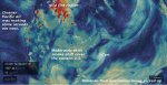
- image001
-
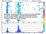
- image002
-
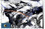
- image003
-
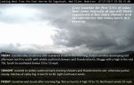
- image004
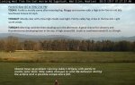
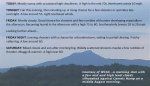
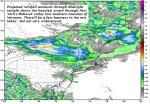
TODAY: Lots of clouds with a chance for a few mountain sprinkles northern areas. Intervals of sunshine away from the mountains. Chilly and quite blustery at times this afternoon. A high mid 50s. Gusty northwest winds 10 to 25 mph with higher gusts across the hills.
Frost Advisory Essex County overnight…
TONIGHT: Mostly clear and colder. Patchy valley fog. A low ranging in the mid 30s slight chance for spotty frost Northeast Kingdom to lower 40s. Light west winds.
SATURDAY: A beauty. Sunshine giving way to some high cloudiness later on. A high in the upper 60s to around 70. Little wind.
Looking further ahead…
SATURDAY NIGHT: Thickening clouds leading to a slight chance for a few showers well after midnight. A low 45 to 50.
SUNDAY: Overcast and damp. Periods of rain or showers…moderate to briefly heavy at times. A high 55 to 60.
MONDAY Labor Day: Partly to mostly sunny, with more cloudiness far northern areas.A low around 50. A high in the mid 70s.
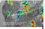
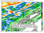
TUESDAY: Mostly cloudy warmer and more humid. Scattered showers and chance for afternoon thunderstorms. A low 60 to 65. A high 75 to 80.
WEDNESDAY: Cloudy. A chance for rain or showers, maybe a thunderstorm some locally heavy. A low 55 to 60. A high in the upper 60s.
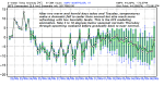
Average low 50 to 55. Normal highs in the low to mid 70s.
RH/9-1 [end]