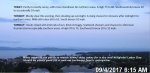
TONIGHT: Early evening showers exit, then turning partially moonlit. Patchy valley fog. A low 45 to 50. Light southwest breeze.
TOMORROW: Morning fog burns off to partial sunshine. Widely scattered afternoon showers. A high around 60. Northwest winds 10 to 15 mph.
SATURDAY NIGHT: Partly cloudy in the evening then clearing and moonlit. Patchy valley fog.A low around 45. Light northwest winds.
SUNDAY: Morning fog, then partly to mostly sunny. Still cool and a little breezy with a high in the mid 60s. Northwest breeze 10 to 15 mph.
Looking further ahead…
SUNDAY NIGHT: Mostly clear and moonlit. A low in the mid 40s.
MONDAY: Morning fog then mostly sunny. Gorgeous and seasonable in temperature. A high in the low 70s.
TUESDAY: Morning fog then mostly sunny. A low in the mid 40s. A high in the mid 70s to near 80.
WEDNESDAY: Morning sunshine after patchy valley fog, then partly sunny in the afternoon. A low in the upper 40s. A high around 75.
THURSDAY: Morning fog then variable clouds but cool. A low around 45. A high around 65.
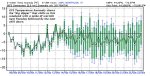
Average low mid 40s to around 50. Normal highs upper 60s to mid 70s.
RH/9-8 [end]
| Virus-free. www.avast.com |