Updated Wednesday Evening Forecast — March 27th, 2019

TONIGHT: Mostly clear. A low 20 to 25. Light south winds.

TOMORROW: Partial sun then becoming cloudy in the afternoon. A rising chance for a few rain showers north of the Barre-Montpelier area. A high in the low 50s. Sap run likely. South breeze 10 to 20 mph.

THURSDAY NIGHT: Chance for a few rain showers, otherwise cloudy. A low in the mid 30s. South breeze 10 mph.

FRIDAY: Lot of clouds with few intervals of sun northern areas. Slight chance for a few rain showers. A high upper 40s to low 50s. Sap run possible. Light southwest winds.

Looking further ahead…

FRIDAY NIGHT: Lots of clouds. A low in the mid 30s.

SATURDAY: Mainly cloudy. Scattered rain showers. A high around 50.

SUNDAY: Overcast and gray. Chance for rain…mixing and changing to accumulating wet snow. A couple inches wet slushy snow possible. A low around 35. A high 45 to 50.

MONDAY: Chance for flurries in the morning then partly to mostly sunny. A low 20 to 25. A high 30 to 35.

TUESDAY: Blues skies and bright sunshine. A low in teens. A high in the 40s. Sap run possible.

Average lows in the 20s. Average highs in the mid to upper 40s.

RH/3-27-19[end]

Updated Wednesday morning forecast — March 27th, 2019

Climate notes

Cyclone Trevor and Cyclone Veronica have smashed into northern Australia – very unusual.

Tropical Storm Iba develops off the coast of Brazil, the 1st in almost 10 years. There have been only a dozen or so in the instrument record that climatologist know of.

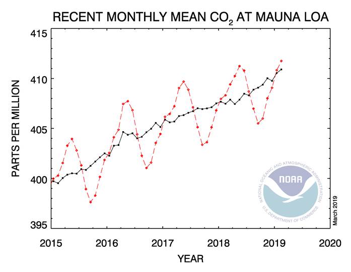
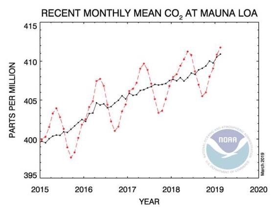
This comes as Greenhouse gasses are on the rise from coal fired power plants. Greenhouse gasses and sunlight interact to excite the molecules to dance and this generates heat. The greenhouse gas process has been known for over 150 years.

This reflects the fact that climate policies around the globe, despite some limited pockets of progress, remain woefully inadequate,” “They’re not even robust enough to offset the increased emissions from economic expansion, especially in the developing world, let alone to spur de-carbonization at levels commensurate with the temperature stabilization goals we’ve committed to under the Paris Agreement.”

“We are in deep trouble, “The climate consequences are catastrophic. I don’t use any word like that very often. But we are headed for disaster, and nobody seems to be able to slow things down.” ~ Rob Jackson Earth system science Stanford University.

TODAY: Tons of sunshine with a few high clouds this afternoon. A high 40 to 45. Light south winds. Sap run possible.

TONIGHT: Mostly clear. A low 20 to 25. South winds 10 mph

THURSDAY: Partly sunny then clouding up. A rising chance for a few rain showers norther of the Barre-Montpelier area. A high in the low 50s. Sap run likely. South breeze 10 to 20 mph.

Looking further ahead…

THURSDAY NIGHT: Chance for a few rain showers northern areas, otherwise cloudy. A low in the 30s.

FRIDAY: Lot of clouds. Widely scattered rain showers or sprinkles. A high mid to upper 40s. Sap run possible.

SATURDAY: Mainly cloudy. Scattered rain showers.A low in the mid 30s. A high in the mid 40s to low 50s.

SUNDAY: Overcast and gray. Chance for rain…mixing and changing to accumulating wet snow. A couple inches wet slushy snow possible. A low around 35. A high 40 to 45.

MONDAY: Chance for flurries in the morning then partly to mostly sunny. A low 20 to 25. A high in the mid 30s.

TUESDAY: Blues skies and bright sunshine. A low in teens. A high in the 40s. Sap run possible.

Average lows in the 20s. Average highs in the mid to upper 40s.

RH/3-27-19[end]

Updated Tuesday Evening Forecast — March 26th, 2019

TONIGHT: Clear and partially moonlit.A low in the teens. Little wind.

TOMORROW: Mostly sunny with a few high clouds. A high 40 to 45. Light south winds. Sap run possible.

WEDNESDAY NIGHT: Mostly clear. A low 20 to 25. South winds 10 mph

THURSDAY: Partly sunny then clouding up. A rising chance for a few rain showers toward the Canadian border. A high in the low 50s. Sap run likely. South breeze 10 to 20 mph.

Looking further ahead…

THURSDAY NIGHT: Chance for a rain showers mainly northern areas, otherwise cloudy. A low in the mid to upper 30s.

FRIDAY: Mostly cloudy. Scattered morning rain showers. A low in the mid 30s to near 40. A high 45 to 50. Sap run possible.

SATURDAY: Clouds with some intervals of sunshine. Scattered rain showers.A low in the mid 30s. A high 55 to 60.

SUNDAY: Cloudy. Chance for rain…mixing and changing to accumulating wet snow. A low around 40. An early high around 50 then temperatures falling in the afternoon.

MONDAY: Chance for flurries in the morning then mostly sunny. A low 20 to 25. A high in the mid 30s.

Average lows in the 20s. Average highs in the mid to upper 40s.

RH/3-26-19[end]

Updated Tuesday morning forecast — March 26th, 2019

TODAY: Bright sunshine and blue skies. A high in the upper 20s to mid 30s. Northwest winds 10 mph.

TONIGHT: Clear and partially moonlit.A low in the teens. Little wind.

WEDNESDAY: Mostly sunny with a few high clouds. A high 40 to 45. Light south winds. Sap run possible.

Looking further ahead…

WEDNESDAY NIGHT: Mostly clear. A low 20 to 25.

THURSDAY: Mixed sun and clouds. A rising chance for a few rain showers toward evening. A high in the low to mid 50s. Sap run likely.

FRIDAY: Mainly cloudy. Scattered morning rain showers. A low in the mid 30s to near 40. A high in the upper 40s to low 50s. Sap run possible.

SATURDAY: Mainly cloudy. Slight chance for a rain shower.A low in the mid 30s. A high upper 50s to low 60s.

SUNDAY: Cloudy. Chance for rain…mixing with wet snow. A low around 40. A high upper 40s to around 50.

MONDAY: Chance for accumulating wet snow in the morning tapering off in the afternoon with partial sunshine developing. A low in the mid 20s. A high in the mid 30s.

Average lows in the 20s. Average highs in the mid to upper 40s.

RH/3-26-19[end]

Updated Monday Evening Forecast — March 25th, 2019

TONIGHT: Clear and partially moonlit. A low 5 to 15 above. Light northwest winds.

TOMORROW: Bright sunshine and blue skies. A high in the upper 20s to mid 30s. Northwest winds 10 mph.

TUESDAY NIGHT: Clear and partially moonlit.A low 5 to 15. Little wind.

WEDNESDAY: Mostly sunny with a few high clouds. A high 40 to 45. Light south winds. Sap run possible

Looking further ahead…

WEDNESDAY NIGHT: Mostly clear. A low in the lower 20s.

THURSDAY: Mixed sun and clouds. A rising chance for a few rain showers late. A high in the low to mid 50s. Sap run likely

FRIDAY: Mainly cloudy. Scattered rain showers. A low in the 30s. A high in the mid 40s to low 50s. Sap run possible.

SATURDAY: Mainly cloudy. Chance for rain showers.A low in the mid 30s. A high in the low 60s.

Average lows in the 20s. Average highs in the mid to upper 40s.

RH/3-25-19[end]

Updated Monday Morning Forecast — March 25th, 2019

TODAY: Brilliant early spring sunshine but chilly for this time of year. A high in the low to mid 30s. Northwest winds 10 to 15 mph.

TONIGHT: Clear and partially moonlit. A low 5 to 15 above. Light northwest winds.

TUESDAY: Bright sunshine and blue skies. A high in the upper 20s to low 30s. Northwest winds 10 mph.

Looking further ahead…

TUESDAY NIGHT: Clear and partially moonlit.A low 5 to 15.

WEDNESDAY: Mostly sunny with a few high clouds. A high 40 to 45. Sap run possible

THURSDAY: Partial morning sun then considerable cloudiness. A low near 20. A high in the low to mid 50s. Sap run likely

FRIDAY: Mainly cloudy. Scattered light rain showers. A low in the low to mid 30s. A high in the upper 40s to mid-50s. Sap run possible.

Average lows in the 20s. Average highs in the mid to upper 40s.

RH/3-25-19[end]

Updated Friday Evening Forecast — March 22nd, 2019

Winter Storm Warning along and east of the Green Mountains except Windsor County. Winter Weather Advisories elsewhere expire Noon on Saturday…

TONIGHT: Snow…with additional accumulations of about 3 to 6” with the most near the Green Mountains and northern tier areas. Becoming blustery with occasional blowing and drifting overnight producing white-outs. A low 25 to 30. Northwest winds picking up to 10 to 25 mph with higher gusts overnight.

TOMORROW: Light snow and snow showers ending as few flurries in the morning. Blustery with occasional blowing and drifting.

Increasing sunshine in the afternoon. A high around 32. Gusty northwest winds 10 to 25 mph.

SATURDAY NIGHT: Clear & partially moonlit. A low in the low to mid teens.

SUNDAY: A beauty. Sunshine giving way to some high cloudiness in the afternoon. A reaching 40 to 45 – Maybe a sap run.

Looking further ahead…

SUNDAY NIGHT: Becoming mostly cloudy. A chance for light snow showers or flurries. Minor accumulation. A low 20 to 25.

MONDAY: Cloudy. A few morning flurries exiting. Mostly sunny in the afternoon. A high near 30.

TUESDAY: Sunny but cold for this time of year. A low zero to 10 above. A high in the mid to upper 20s.

WEDNESDAY: Mostly sunny few high clouds. A low in the single digits. Milder in the afternoon with a high near 40. Sap run possible.

Average lows in the 20s. Average highs in the 40s.

RH/3-22-19[end]

Updated Friday Morning Forecast — March 22nd, 2019

Winter Storm Warning Green Mountains and northern tier regions into Saturday morning. Winter Weather advisories elsewhere…

TODAY: Gray. Periods of wet slushy snow…moderate at times this morning… possibly mixed with rain valley floors. Slushy accumulation 2 to locally 6 with majority of snowfall above 1200 ft elevation. A high 32 to 35. Winds becoming north to northeast 10 mph.

TONIGHT: Periods of wet snow likely…possibly mixed with rain valley floors. Additional accumulation of a few inches especially Green Mountains and high terrain. A low upper 20s to low 30s. Northwest winds picking up to 10 to 25 mph.

SATURDAY: Snow…tapering to scattered snow showers and flurries in the morning before exiting. Intervals of afternoon sunshine developing away from the mountains. Blustery. A high near 32. Gusty northwest winds 10 to 25 mph.

Looking further ahead…

SATURDAY NIGHT: Clear & partially moonlit. A low 10 to 15.

SUNDAY: A beauty. Sunshine giving way to some high cloudiness. A reaching into the mid 40s – Likely a sap run.

MONDAY: Cloudy. Chance for accumulating snow showers with a dusting to an inch. A low near 25. A high around 30.

TUESDAY: Sunny but well below normal in temperatures. A low zero to 10 above. A high in the mid to upper 20s.

WEDNESDAY: A few high clouds filtering the sunshine. A low in the single digits. Milder in the afternoon with a high near 40. Sap run possible.

Average lows in the 20s. Average highs in the 40s.

RH/3-22-19[end]

Updated Thursday Evening forecast — March 21st, 2019

Winter Storm Warning Green Mountains and northern tier regions overnight into Saturday morning. Winter Weather advisories elsewhere…

TONIGHT: Cloudy. Widely scattered rain showers mixing with wet snow flakes later this evening. Wet snow develops overnight leading to a couple slushy inches of accumulation. Slippery travel. A low near 32. Southeast winds 10 mph.

TOMORROW: Gray. Periods of wet slushy snow possibly mixed with rain valley floors. Slushy accumulation 1 to locally 4 inches valleys but several inches above 1500 ft. A high around 35. Winds becoming north to northeast 10 mph.

FRIDAY NIGHT: Periods of wet snow likely…possibly mixed with rain valley floors. Additional accumulation of a few inches especially Green Mountains and high terrain. A low upper 20s to low 30s. Northwest winds picking up to 10 to 25 mph.

SATURDAY: Snow…tapering to scattered snow showers and flurries in the morning before exiting. Intervals of afternoon sunshine developing away from the mountains. Blustery. A high in the lower 30s. Gusty northwest winds 10 to 25 mph.

Looking further ahead…

SATURDAY NIGHT: Mostly clear. A low 15 to 20.

SUNDAY: A beauty. Sunshine giving way to some high cloudiness. A reaching into the mid 40s – Likely a sap run.

MONDAY: Cloudy. Chance for accumulating snow showers. Light coating of wet snow possible. A low in the 20s. A high 30 to 35.

Average lows in the upper-teens to mid 20s. Average highs in the 40s.

RH/3-21-19[end]

Updated |Thursday morning forecast — March 21st, 2019

TODAY: Some hints of early sun, then gray but milder. Rain showers developing toward far southern and western areas this afternoon overspreading the region before dark. A high around 45. Sap run likely. South winds 10 to 15 mph.

TONIGHT: Cloudy. Evening rain showers. Rain or rain showers mixing with wet snow flakes higher terrain gradually mixing with wet snow overnight. Slushy accumulation of an inch with slippery travel in spots. A low near 32. Southeast winds 10 mph.

Winter Storm Watch Green Mountains and northern tier regions Friday into Saturday morning…

FRIDAY: Gray. Periods of wet slushy snow possibly mixed with rain valley floors. Slushy accumulation 1 to 3 inches valleys but several inches above 1500 ft. A high around 35. Winds becoming north to northeast 10 mph.

Looking further ahead…

FRIDAY NIGHT: Periods of wet snow likely…possibly mixed with rain valley floors. Additional accumulation of a few inches especially Green Mountains and points west. A low upper 20s to low 30s.

SATURDAY: Snow…tapering to scattered snow showers and flurries in the morning before exiting. Intervals of afternoon sunshine developing away from the mountains. Blustery. A high 30 to 35. Gusty northwest winds.

SUNDAY: A beauty. Sunshine giving way to some high cloudiness. A low 15 to 20. A reaching into the mid 40s – Likely a sap run.

MONDAY: Cloudy. Chance for accumulating snow showers. Light coating of wet snow possible. A low in the 20s. A high 30 to 35.

Average lows in the upper-teens to mid 20s. Average highs in the 40s.

RH/3-21-19[end]