Updated Tuesday Morning Forecast — April 23rd, 2019

TODAY: Clouds with a shower Northeast Kingdom giving way to a couple sunny periods. More clouds again this afternoon, still mild. A high mid 60s to low 70s. Light northeast winds.

TONIGHT: Cloudy. Rain showers developing west to east later this evening. Patchy valley fog. A low 40 to 45. Southeast 10 mph.

WEDNESDAY: Gray skies and rather raw. Lingering showers northern areas with areas of fog and drizzle. A high in the mid to upper 40s. Winds becoming west to northwesterly 10 to 15 mph.

Looking further ahead…

WEDNESDAY NIGHT: Evening sprinkles exiting to clearing skies. Patchy valley fog. A low in the low to mid 30s.

THURSDAY: Pick of the week but cooler. Morning cloudiness gives way to lots of sunshine. A high 55 to 60.

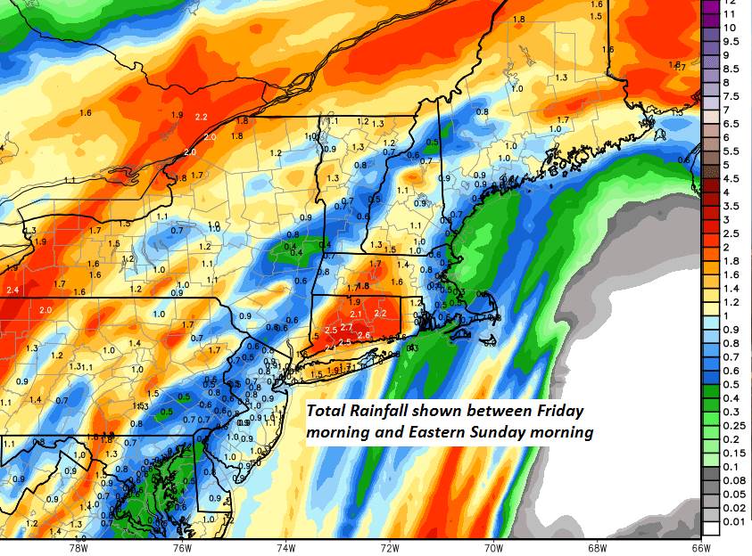
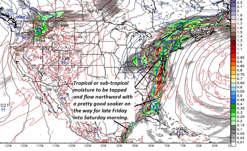
FRIDAY: Cloudy and gray. Good chance for periods of rain or rain showers…moderate at times. Chilly. A low 35 to 40. A high in the mid to upper 40s.

SATURDAY: Mainly cloudy with lingering showers and rather cool. A low in the mid to upper 30s. A high 45 to 50.

SUNDAY: Mostly cloudy with a chance for an afternoon shower. A low in the 30s. A high upper 40s to low 50s

MONDAY: Mostly sunny with some high cloudiness. Slightly milder. A low in the 20s. A high low to mid 50s.

Average lows in the 30s. Average highs in the 50s.

RH/4-23-19[end]

Updated Monday Evening Fore3cast — April 22nd, 2019

TONIGHT: Clear northern & western areas. More clouds toward New Hampshire with a period of showers. A low upper 30s to low 40s. Light northeast winds.

TOMORROW: Clouds, but with a couple sunny periods and still mild. A high mid to upper 60s. Light northeast winds.

TUESDAY NIGHT: Cloudy. A period of rain showers becoming likely late evening. A low 40 to 45. Southeast 10 to 15 mph.

WEDNESDAY: Gray skies and rather raw with lingering showers northern areas. Areas of fog and drizzle. A high in the low to mid 40s. Wind becoming westerly 10 to 15 mph.

Looking further ahead…

WEDNESDAY NIGHT: Evening clouds then clearing. A low in the low to mid 30s with patchy frost.

THURSDAY: Pick of the week but cooler. Morning clouds give way to lots of sunshine. A high 55 to 60.

FRIDAY: Cloudy and gray. Chance for rain or rain showers moderate at times. Chilly. A low mid 30s to mid 40s. A high in the mid to upper 40s.

SATURDAY: Morning sunshine, gives way to more clouds. Below normal in temperature. A low in the mid to upper 30s. A high 40 to 45.

Average lows in the 30s. Average highs in the 50s.

RH/4-22-19[end]

Updated Monday morning Forecast — April 22nd, 2019

TODAY: Mixed clouds and sun becoming mainly cloudy eastern Vermont. Partly sunny western areas. A rising chance for showers across southern areas. Dry northern areas. A high in the mid 60 to low 70s. North to northeast breeze 10 mph.

TONIGHT: Scattered clouds. A low upper 30s to mid 40s. Light northeast winds.

TUESDAY: Intervals of sunshine but otherwise lots of clouds. A high upper 60s to low 70s. Light northwest winds.

Looking further ahead…

TUESDAY NIGHT: Cloudy and damp. A rising chance for rain showers before midnight. A low upper 30s to mid 40s.

WEDNESDAY: Gray skies with lingering showers. A High in the mid 50s.

THURSDAY: Pick of the week but cooler. Morning clouds give way to lots of sunshine. A low raging through the 30s. A high 55 to 60.

FRIDAY: Cloudy and gray. Chance for rain or rain showers moderate at times. Chilly. A low mid 30s to mid 40s. A high in the mid to upper 40s.

SATURDAY: Morning sunshine, gives way to more clouds. Below normal in temperature. A low in the 30s. A high 40 to 45.

Average lows in the 30s. Average highs in the 50s.

RH/4-22-19[end]

Updated Friday Evening Forecast — April 19th, 2019

Flood Watch through Sunday morning…

TONIGHT: Cloudy. Rain developing this evening…moderate at times. Areas of fog. Fairly mild. A low around 55. South winds 10 mph.

TOMORROW: Gray, damp Areas of fog…but mild. Rain…moderate at times early…tapering to scattered showers in the afternoon. Expect rising streams and rivers in the morning. A high upper 60s to low 70s. Southeast breeze 10 to 15 mph.

SATURDAY NIGHT: Scattered showers…especially east of the Green Mountains, otherwise some partial clearing late. Expect high water on many streams and rivers. A low 45 to 50. South winds 10 mph.

EASTER SUNDAY: Sunshine mixed with clouds. Warm, with a high in the lower 70s. South winds 10 mph.

Looking further ahead…

SUNDAY NIGHT: Scattered clouds. Patchy valley fog. A low around 45

MONDAY: Partial sunshine gives way to lots of clouds. Rain showers becoming likely. Maybe a few rumbles of thunder. A high in the mid 50s to low 60s.

TUESDAY: Scattered rain showers early departing to partial afternoon sunshine. A low in the 40s. A high around 55.

WEDNESDAY: Mainly gray. Chance for showers. A low 40 to 45. A High in mid 40s to low 50s.

Average lows in the 30s. Average highs in the 50s.

RH/4-19-19[end]

Updated Friday Morning Forecast — April 19th, 2019

Full “Pink Moon” 7:12 AM

TODAY: Clouds with a few breaks of sun. Scattered sprinkles near the Quebec border, giving way to showers region wide later this afternoon. A high 65 to 70. South to southwest winds 10 to 15 mph.

Flood Watch Friday Evening through Sunday morning…

TONIGHT: Cloudy. Rain…moderate at times. Areas of fog. Fairly mild. A low around 55. South winds 10 mph.

SATURDAY: Gray, damp but mild. Rain…moderate at times early…tapering to scattered showers in the afternoon. Expecting rising streams and rivers. Areas of fog. A high upper 60s to low 70s. Southeast breeze 10 to 15 mph.

Looking further ahead…

SATURDAY NIGHT: Scattered showers…especially east of the Green Mountains, otherwise some partial clearing late. Expect highs water on many streams and rivers. A low 45 to 50.

EASTER SUNDAY: Sunshine mixed with clouds but looking “dry”. Warmer with a high in the lower 70s.

MONDAY: Partial sunshine gives way to lots of clouds. Rain showers becoming likely. Maybe a few rumbles of thunder. A low around 40. A high in the 50s.

TUESDAY: Scattered rain showers early departing to partial afternoon sunshine. A low 35 to 45. A high in the 50s.

WEDNESDAY: Mainly gray. Scattered rain showers. A low 40 to 45. A high in the 50s.

Average lows in the 30s. Average highs in the 50s.

RH/4-19-19[end]

Updated Thursday Evening Forecast — April 18th, 2019

TONIGHT: Cloudy with occasional rain showers. Areas of fog. A low around 45. South winds 10 to 15 mph.

Full “Pink Moon” 7:12 AM

TOMORROW: Mostly cloudy but mild. Chance for morning sprinkles near the Quebec border. Scattered showers developing later on everywhere. A high 65 to 70. South to southwest winds 10 to 15 mph.

Flood Watch Friday Evening through Sunday morning…

FRIDAY NIGHT: Cloudy. Rain…moderate at times. Areas of fog. Fairly mild. A low around 55. South winds 10 mph.

SATURDAY: Gray, damp but mild. Rain… possibly moderate at times…tapering to scattered showers later in the afternoon. Watch for a potential for high water on area rivers and streams. Areas of fog. A high 65 to 70. Southeast breeze 10 to 15 mph.

Looking further ahead…

SATURDAY NIGHT: Scattered showers especially east of the Green Mountains, otherwise some partial clearing late. A low 45 to 50.

EASTER SUNDAY: Sunshine mixed with clouds but looking “dry”. Warmer with a high in the lower 70s.

MONDAY: Sunshine mixed with cloudy periods. Isolated rain showers. A low around 40. A high in the 50s.

TUESDAY: Partly sunny with few more clouds in the afternoon. A low 35 to 45. A high in the 50s.

WEDNESDAY: Mainly gray. Scattered rain showers. A low 40 to 45. A high in the 50s.

Average lows in the 30s. Average highs in the 50s.

RH/4-17-19[end]

Updated Thursday Morning Forecast — April 18th, 2019

TODAY: Lots of clouds. Watch for brief spotty freezing rain for a short period this morning…otherwise passing rain showers this morning. A high 50 to 55 South to southeast breeze 10 to 20 mph.

TONIGHT: Cloudy with occasional rain showers. Areas of fog. A low around 45. South winds 10 to 15 mph.

Full “Pink Moon” 7:12 AM

FRIDAY: Mostly cloudy but mild. A sprinkle far northern areas then scattered afternoon showers. A high 65 to 70. South to southwest winds 10 mph.

Looking further ahead…

Flood Watch Friday Evening through Sunday morning…

FRIDAY NIGHT: Cloudy with periods of rain likely. Areas of fog. Fairly mild. A low around 55.

SATURDAY: Gray, damp but mild. Periods of rain likely… possibly moderate at times…tapering to scattered showers later in the afternoon. Watch for a potential for high water on area rivers and streams. Areas of fog A high around 65.

SUNDAY: Mainly cloudy and damp. Widely scattered showers mainly east of the Greens. A few breaks of sun late. A low 45 to 50. A high in the upper 60s to around 70.

MONDAY: Sunshine mixing with cloudy periods. Chance for a few leftover showers. A low around 40. A high in the 50s.

TUESDAY: Partly to mostly sunny after a frosty morning. A low 25 to 30. A high in the 50s.

Average lows in the 30s. Average highs in the 50s.

RH/4-17-19[end]

Updated Wednesday Evening Forecast — April 17th, 2019

TONIGHT: Mostly clear this evening, increasing clouds overnight. Scattered rain showers near daybreak southern areas. A low upper 20s Northeast Kingdom to mid 30s most places. Light southeast winds.

TOMORROW: Lots of clouds. A few passing rain showers mainly in the morning. A high in the low 50s. South to southeast breeze 10 to 20 mph.

THURSDAY NIGHT: Cloudy with occasional rain showers. Areas of fog. A low around 45. South winds 10 to 15 mph.

Full “Pink Moon” 7:12 AM

FRIDAY: Mostly cloudy but mild. A sprinkle far northern areas then scattered afternoon showers. A high 65 to 70. South to southwest winds 10 mph.

Looking further ahead…

FRIDAY NIGHT: Cloudy with periods of rain likely. Areas of fog. Fairly mild. A low around 55.

SATURDAY: Gray, damp but mild. Periods of rain likely… possibly moderate at times…tapering to scattered showers later in the afternoon. Watch for a potential for high water on area rivers and streams. Areas of fog A high low to mid 60s.

SUNDAY: Mainly cloudy and damp. Good chance for more showers. A few breaks of sun late. A low 45 to 50. A high 60 to 65.

MONDAY: Sunshine mixing with cloudy periods. Chance for a few leftover showers. A low around 40. A high in the 50s.

TUESDAY: Partly to mostly sunny after a frosty morning. A low 25 to 30. A high in the 50s.

Average lows in the 30s. Average highs in the 50s.

RH/4-17-19[end]

Updated Wednesday Morning Weather — April 17th, 2019

TODAY: Pick of the week with bright sunshine and blue skies. A high 50 to 55. Light north winds.

TONIGHT: Fair in the evening, then clouding up overnight. An early low 32 to 35. Light southeast winds.

THURSDAY: Lots of clouds. A few passing rain showers mainly in the morning. A high in the low 50s. South to southeast breeze 10 to 20 mph.

Looking further ahead…

THURSDAY NIGHT: Cloudy with occasional showers. A low in the mid to upper 40s.

FRIDAY: Mostly cloudy. Scattered rain showers in the afternoon. A high mid 60s to near 70.

SATURDAY: Gray, damp but mild. Chance for rain, possibly moderate at times in the morning tapering to scattered showers in the afternoon. Some potential for high water on area rivers and streams. A low 50 to 55. A high low to mid 60s.

SUNDAY: Mainly cloudy and damp. Chance for lingering showers. A few breaks of sun late. A low 45 to 50. A high 60 to 65.

MONDAY: Sunshine mixing with cloudy periods. Chance for a few leftover showers. A low around 40. A high in the 50s.

TUESDAY: Partly to mostly sunny after a frosty morning. A low 25 to 30. A high in the 50s.

Average lows in the 30s. Average highs in the 50s.

RH/4-17-19[end]

Updated Tuesday Evening Forecast — April 16th, 2019

TONIGHT: Mostly clear and frosty. A low mid 20s to low 30s. Light northwest winds.

TOMORROW: Pick of the week with bright sunshine and blue skies. A high 50 to 55. Light north winds.

WEDNESDAY NIGHT: Fair in the evening, then clouding up overnight. An early low around 30. Light southeast winds.

THURSDAY: Lots of clouds. A few passing rain showers. A high in the low 50s. South to southeast breeze 10 to 20 mph.

Looking further ahead…

THURSDAY NIGHT: Cloudy with an occasional light shower. A low in the mid to upper 40s.

FRIDAY: Mostly cloudy. Chance for a brief shower. A high mid 60s to near 70.

SATURDAY: Gray but damp and milder. Chance for rain, possibly moderate at times. Watch for potential high water area river and streams. A low in the around 50. A high low to mid 60s.

SUNDAY: Mostly cloudy but continued damp. Chance for lingering showers. A low around 45. A high around 60.

Average lows in the 30s. Average highs in the 50s.

RH/4-16-19[end]