TODAY: Morning sun gives way to cloudy periods toward mid day. A few showers to roll through. A little warmer but much more humid this afternoon. A high in the low 80s. Southwest winds 10 mph.
“Full Buck Moon” at 5:39 PM Tuesday Evening
TONIGHT: Fair and fully moonlit this evening. Increasing clouds overnight, leading to a rising chance for showers well after midnight.Rather muggy.A low near 65. Light southwest winds.
WEDNESDAY: Considerable cloudiness, warm and sticky. Showers likely…some briefly heavy with a few rumbles of thunder possible. A high in the mid to upper 70s.Light southwest winds.
Looking further ahead…
WEDNESDAY NIGHT: Chance for early evening shower, otherwise partly cloudy. A low near 60.
THURSDAY: Mostly sunny in the morning variable clouds in the afternoon. Not so muggy. A high around 80.
FRIDAY: Mixed sun and clouds. Chance for a showers & afternoon thunderstorms. Hot and sticky. A low 60 to 65. A high upper 80s to around 90.
SATURDAY: Hazy hot and humid. Chance for showers and thunderstorms later in the evening. A low near 70. A high pushing into the upper 80s to low 90s.
SUNDAY: Mixed clouds and sunshine. Scattered afternoon thunderstorms winding down early evening. A low mid 60s to near 70. A high in the mid 80s.
Average lows upper 50s to mid 60s. Average highs upper 70s to mid 80s.
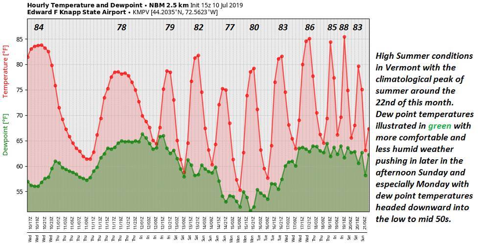
Warmest 90 days of meteorological summer peaks July 22nd…

RH/7-16-19[end]