Updated Friday Evening Forecast — March 20th, 2020

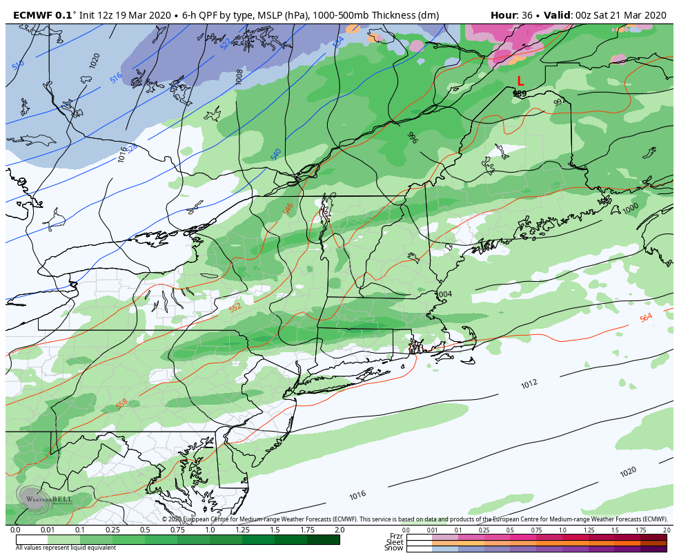
TONIGHT: Showers with a few rumbles of thunder possible, with locally strong gusty winds early, giving way to a few flurries before ending. Blustery and sharply colder. A low 20 to 25. West to northwest winds 10 to 25 mph with higher gusts.

TOMORROW: A couple clouds but otherwise lots of sunshine. A high 32 to 35. Northwest winds 10 to 15 mph diminishing in the afternoon.

SATURDAY NIGHT: Clear and chilly with a few high clouds. A low mid to upper teens. Light north winds.

SUNDAY: Bright sun and blue skies. A high 32 to 35. Northwest winds 10 mph.

Looking further ahead…

SUNDAY NIGHT: Increasing mid and high cloudiness. An evening low around 20.

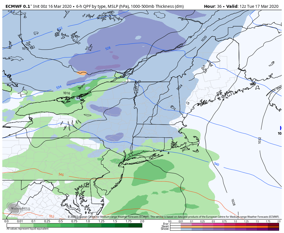
MONDAY: Clouding up. Rising chance for accumulating snow developing late. A few to several inches possible. A high around 35.

TUESDAY: Couple leftover flurries gives way to mostly cloudy skies. A low 25 to 30. A high around 40.

WEDNESDAY: Gray skies. Chance for wet snow mixed with rain valley floors. A low 15 to 20. A high in the mid-30s.

Average lows upper-teens to mid-20s, average highs upper 30s to mid-40s…

RH/3-20[end]

Updated Friday Morning forecast — March 20th, 2020

TODAY: Occasional rain exits mid to late morning. A break, then showers with a risk for isolated thunderstorms this afternoon. Breezy to windy at times this afternoon. Temperatures peaking around 65. Breezy to windy late. Southwest winds 10 to 25 mph with locally higher gusts.

TONIGHT: Scattered rain showers…mixing and changing to snow showers. Minor accumulation. Blustery and sharply colder. A low 20 to 25. West to northwest winds 10 to 25 mph with higher gusts.

SATURDAY: A couple clouds early, then mostly sunny. Blustery and colder. A high 30 to 35. Northwest winds 10 to 20 mph diminishing in the afternoon.

Looking further ahead…

SATURDAY NIGHT: Clear and chilly with a few high clouds. A low in the low to mid-teens.

SUNDAY: Bright sun and blue skies. A high 32 to 35.

MONDAY: Clouding up. Rising chance for accumulating snow in the afternoon. A few to several inches possible. A low 15 to 20. A high mid-30s to low 40s.

TUESDAY: Chance for snow showers exiting early, otherwise partly to mostly cloudy. A low mid to upper 20s. A high around 40.

Average lows upper-teens to mid-20s, average highs upper 30s to mid-40s…

RH/3-20[end]

Updated Thursday Evening Forecast — March 19th, 2020

Vernal Equinox occurs 11:49 PM…

TONIGHT: Cloudy. Occasional rain showers developing after midnight. An evening low near 35 with rising temperatures overnight. Southeast breeze 10 mph.

TOMORROW: Mostly cloudy and spring-like. Occasional rain in the morning moderate at times. A break around mid-day, then a round of showers with a risk for thunder in the afternoon. Temperatures peaking in the 60s. Breezy to windy late. Southwest winds 10 to 25 mph with locally higher gusts.

FRIDAY NIGHT: Scattered rain showers changing to wet snow showers with minor accumulation. Blustery and sharply colder. A low 20 to 25. West to northwest winds 10 to 25 mph with higher gusts.

SATURDAY: A couple clouds early, then mostly sunny. Blustery and colder. A high 30 to 35. Northwest winds 10 to 20 mph diminishing in the afternoon.

Looking further ahead…

SATURDAY NIGHT: Clear and chilly with a few high clouds. A low in the low to mid-teens.

SUNDAY: Bright sun and blue skies. A high 32 to 35.

MONDAY: Filtered morning sun then thickening clouds leading to a chance for accumulating snow toward evening. A few inches possible Monday night. A low 15 to 20. A high mid-30s to low 40s.

TUESDAY: Chance for snow showers exiting early, otherwise partly to mostly cloudy. A low mid to upper 20s. A high around 40.

Average lows upper-teens to mid-20s, average highs upper 30s to mid-40s…

RH/3-19[end]

Updated Thursday Morning Forecast — March 19th, 2020

TODAY: Gray skies. Occasional snow showers or flurries…exiting late morning. Dusting to an inch north, 1 to locally 3” southern higher terrain thru 10 AM. A late day high low to mid 40s. Southeast breeze 10 to 15 mph.

Vernal Equinox occurs 11:49 PM Thursday night…

TONIGHT: Cloudy. Occasional rain showers developing after midnight. An evening low near 35 with rising temperatures overnight. Southeast breeze 10 mph.

TOMORROW: Mostly cloudy and spring-like. Occasional rain in the morning. A break around mid-day, then a round of showers with a risk for thunder…moderate to heavy at times in the afternoon. Temperatures peaking in the 60s. Breezy to windy late. Southwest winds 10 to 25 mph with locally higher gusts.

Looking further ahead…

FRIDAY NIGHT: Scattered rain showers changing to wet snow showers with minor accumulation. Blustery and sharply colder. A low 20 to 25. Strong gusty west to northwest winds.

SATURDAY: A stray flurry early, then partly to mostly sunny. Blustery and colder. A high 30 to 35.

SUNDAY: Bright sun and blue skies. A low in the low to mid-teens. A high 32 to 35.

MONDAY: Morning sun then clouds thickening late leading to a chance for accumulating snow a few inches possible. A low 15 to 20. A high mid-30s to low 40s.

TUESDAY: Chance for snow showers exiting early, otherwise partly to mostly cloudy. A low mid to upper 20s. A high around 40.

Average lows mid-teens to low 20s, average highs upper 30s to mid-40s….

RH/3-19[end]

Updated Wednesday Forecast — March 18th, 2020

TONIGHT: Thickening clouds. Light accumulating snow or flurries developing toward daybreak. Accumulation dusting to an inch. A low around 32 degrees. Light southeast winds.

TOMORROW: Mainly cloudy. Occasional snow showers or flurries…exiting by early afternoon. Dusting to an inch north, 1 to locally 3” southern higher terrain. An afternoon high low to mid 40s. Southeast breeze 10 to 15 mph.

Vernal Equinox occurs 11:49 PM Thursday night…

THURSDAY NIGHT: Cloudy. Occasional rain showers developing after midnight. An evening low near 35 with rising temperatures overnight. Southeast breeze 10 mph.

FRIDAY: Mostly cloudy and spring-like. Occasional rain showers in the morning. A break, then a round rain showers moderate at times…with a chance for a thunderstorm with gusty winds late in the afternoon. Temperatures peaking in the 60s. Breezy to windy late. Southwest winds 10 to 25 mph with locally higher gusts.

Looking further ahead…

FRIDAY NIGHT: Scattered rain showers changing to wet snow showers with minor accumulation. Blustery and sharply colder. A low 20 to 25. Strong gusty west to northwest winds.

SATURDAY: A stray flurry early, then partly to mostly sunny. Blustery and colder. A high around 32.

SUNDAY: Bright sun and blue skies. A morning low 10 to 15. A high near 35.

MONDAY: Morning sun then increasing high clouds thickening up late. A low 15 to 20. A high near 40.

Average lows mid-teens to low 20s, average highs upper 30s to mid-40s….

RH/3-18[end]

Updated Wednesday Morning Forecast — March 14th, 2020

TODAY: Sunshine gives way high cloudiness in the afternoon. A high low to mid 40s. Possible sap run. Light northwest winds.

TONIGHT: Considerable cloudiness. Light accumulating snow or flurries developing overnight Barre-Montpelier area and points south. Accumulation dusting to an inch north. A low 32 to 35. Light southeast winds.

THURSDAY: Mainly cloudy. Occasional snow showers or flurries…exiting late morning. Dusting to an inch north with up to 3” southern elevated terrain. An afternoon high low to mid 40s. Southeast breeze 10 mph.

Looking further ahead…

Vernal Equinox occurs 11:49 PM Thursday night…

THURSDAY NIGHT: Cloudy. Occasional rain showers developing after midnight. A low 35 to 40.

FRIDAY: Mostly cloudy and spring-like. Occasional rain showers in the morning. A break, then a round rain showers moderate at times…maybe a rumble of thunder in the afternoon. Temperatures peaking in the 60s then sharply colder…blustery.

SATURDAY: A stray flurry early, then partly to mostly sunny. Blustery and colder. A low 25 to 30. A high 32 to 35.

SUNDAY: Bright sun and blue skies. A morning low in the teens. A high 30 to 35.

MONDAY: Morning sun then increasing high clouds thickening up late. A low 15 to 20. A high around 40.

Average lows mid-teens to low 20s, average highs upper 30s to mid-40s….

RH/3-18[end]

Updated Tuesday Evening Forecast — March 17th, 2020

TONIGHT: A leftover rain or wet snow shower Northeast Kingdom into mid evening, then clearing. A low mid to upper 20s. West winds 10 mph.

TOMORROW: Sunshine gives way high cloudiness in the afternoon. A high low to mid 40s. Possible sap run. Light northwest winds.

WEDNESDAY NIGHT: Considerable cloudiness. Light accumulating snow likely, especially central and southern areas with just flurries northern areas. Accumulation dusting to an inch north. A low 32 to 35. Light southeast winds.

THURSDAY: Mainly cloudy. Occasional snow showers or flurries…exiting late morning. Dusting to an inch north with 1 to locally 4” central and southern areas. An afternoon high 40 to 45. Southeast breeze 10 mph.

Looking further ahead…

Vernal Equinox occurs 11:49 PM Thursday night…

THURSDAY NIGHT: Cloudy. Occasional rain showers developing after midnight. A low in the mid to upper 30s.

FRIDAY: Mostly cloudy and spring-like. Occasional rain showers in the morning. A break, then a round rain showers moderate at times…maybe a rumble of thunder in the afternoon. Temperatures peaking in the 60s then sharply colder…blustery.

SATURDAY: A stray flurry early, then partly to mostly sunny. Blustery and colder. A low 25 to 30. A high around 32 degrees.

SUNDAY: Bright sun and blue skies. A morning low 5 to 15 above. A high 30 to 35.

Average lows mid-teens to low 20s, average highs upper 30s to mid-40s….

RH/3-17[end]

Updated Tuesday Morning Forecast — March 17th, 2020

TODAY: Gray. Periods of accumulating wet snow…mixed with rain at times valley floors. Accumulations of dusting to 2 inches especially higher terrain. A high upper 30s to mid-40s. Southeast winds 10 to 15 mph.

TONIGHT: A leftover rain or wet snow shower in the evening before clearing skies. A low mid to upper 20s. West winds 10 mph.

WEDNESDAY: Sunshine gives way high cloudiness in the afternoon. A high low to mid 40s. Possible sap run. Light northwest winds.

Looking further ahead…

WEDNESDAY NIGHT: Considerable cloudiness. Light accumulating snow likely, especially central and southern areas with just flurries northern areas. Accumulation dusting to an inch north. A low 32 to 35.

THURSDAY: Mainly cloudy. Occasional light snow or snow showers early…exiting late morning. Up to 4” possible toward southern Green Mountains. A high 40 to 45.

Vernal Equinox occurs 11:49 PM Thursday night…

FRIDAY: Mostly cloudy and spring-like. Chance for rain early with spotty freezing rain making for slick travel. Chance for a round of showers…maybe a rumble of thunder in the afternoon. A low in the mid to upper 30s. A high 60 to 65.

SATURDAY: Clouds with a few flurries early, then lots of afternoon sun. Blustery and colder. A low 25 to 30. A high around 32 degrees.

SUNDAY: Bright sun and blue skies. A morning low 5 to 15 above. A high 30 to 35.

Average lows mid-teens to low 20s, average highs upper 30s to mid-40s….

RH/3-17[end]

Updated Monday morning Forecast — March 16th, 2020

TONIGHT: Fair this evening, otherwise thickening clouds. Periods of snow toward daybreak with a coating of snow. A low mid to upper 20s. Light southeast winds.

TOMORROW: Gray. Periods of accumulating wet snow…mixed with rain at times valley floors. Accumulations of 1 to locally 3”most northern higher terrain. A high upper 30s to around 40. Southeast winds 10 to 15 mph.

TUESDAY NIGHT: A leftover rain or wet snow shower in the evening before clearing skies. A low ranging thru the 20s. West winds 10 mph.

WEDNESDAY: Sunshine gives way high cloudiness in the afternoon. A high in the low to mid 40s. Light northwest winds.

Looking further ahead…

WEDNESDAY NIGHT: Considerable cloudiness. Chance for light accumulating snow overnight. A low 30 to 35

THURSDAY: Mainly cloudy. Wet snow mixed with rain valleys floors exiting around mid-day. A high upper 30s to low 40s.

FRIDAY: Considerable cloudiness. A brief period of rain early, tapers off as scattered rain and wet snow showers. An evening low near 32. A high in the upper 50s to low 60s.

SATURDAY: Clouds with a few flurries early, then lots of afternoon sun. Blustery and colder. A low 25 to 30. A high around 32 degrees.

SUNDAY: Bright sun and blue skies. A morning low 5 to 15 above. A high 30 to 35.

Average lows mid-teens to low 20s, average highs upper 30s to mid-40s….

RH/3-16[end]

Updated Monday morning Forecast — March 16th, 2020

TODAY: Sunshine become filtered through high cloudiness. A high upper 30s to around 40. Light north winds.

TONIGHT: Thickening clouds. A rising chance for periods of snow toward daybreak. A low mid to upper 20s. Light southeast winds.

TUESDAY: Gray. Periods of accumulating wet snow…mixed with rain at times in the afternoon valley floors. Accumulations of 1 to 3” local higher terrain. A low 25 to 30. A high upper 30s to around 40. Southeast winds 10 to 15 mph.

Looking further ahead…

TUESDAY NIGHT: Mixed rain and snow showers exiting in the evening with additional minor accumulation. Clearing skies developing overnight. A low ranging thru the 20s.

WEDNESDAY: Sunshine gives way to increasing clouds in the afternoon. A high in the low to mid 40s.

THURSDAY: Overcast. Periods of accumulating wet snow mixed with rain shower in the afternoon. A low 30 to 35. A high upper 30s to low 40s.

FRIDAY: Considerable cloudiness. A chance for rain with spotty freezing rain possible at onset. A low in the low to mid 30s. A high in the mid-50s to low 60s.

Average lows mid-teens to low 20s, average highs upper 30s to mid-40s….

RH/3-16[end]