Over the next several days, sprawling high pressure across Canada edges out significant clouds and foul weather. Some of our best late-summer-like conditions were just around the corner, especially this weekend into the start of next week.

Over the next several days, sprawling high pressure across Canada edges out significant clouds and foul weather. Some of our best late-summer-like conditions were just around the corner, especially this weekend into the start of next week.
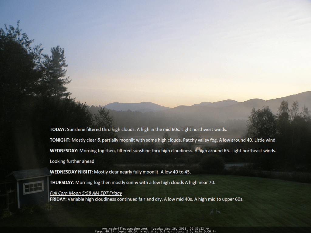
TONIGHT: Mostly clear & partially moonlit with some high clouds overnight. Patchy valley fog. A low 40 to 45. Light northeast winds.
TOMORROW: Sunshine filtered thru high cloudiness. A high in the mid 60s. Light northwest winds.
TUESDAY NIGHT: Mostly clear & partially moonlit with some high cloudiness. Patchy valley fog. A low around 40. Little wind.
WEDNESDAY: Morning fog then, filtered sunshine thru high cloudiness. A high around 65. Light northeast winds.
Looking further ahead
WEDNESDAY NIGHT: Mostly clear nearly fully moonlit.A low 40 to 45.
THURSDAY: Morning fog then mostly sunny with a few high clouds A high near 70.
Full Corn Moon 5:58 AM EDT Friday
FRIDAY: Variable high cloudiness continued fair and dry. A low mid 40s. A high 65 to 70.
SATURDAY: Mostly sunny after morning fog with a few afternoon clouds. A low 45 to 50. A high 70 to 75.
SUNDAY: Bright sunshine. A low upper 40s. A high pushing near 75.
Average lows upper 30s to mid 40s. Average highs 60 to 65.
Admin: off Wednesday afternoon & Thursday.
RH/9-25 forecast][end]

Some high elevation snow was advertised for most of the western mountain elevations and even into the northern high plains, and across northern Canada coast to coast with a hint of some early winter that kicks in later this week with reinforcement of new snows further eastward eventually into northern Quebec into the second week of October. With a strong El Nino this appears to be its opposite to start winter and should not be confused.
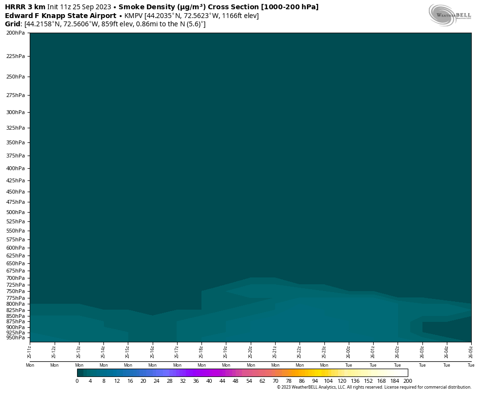
This cross-section shows a smoke layer down to the surface from thin but old wildfire smoke that originated in northern Alberta from fires that pulse off and on in the Boreal Forest region of Canada.

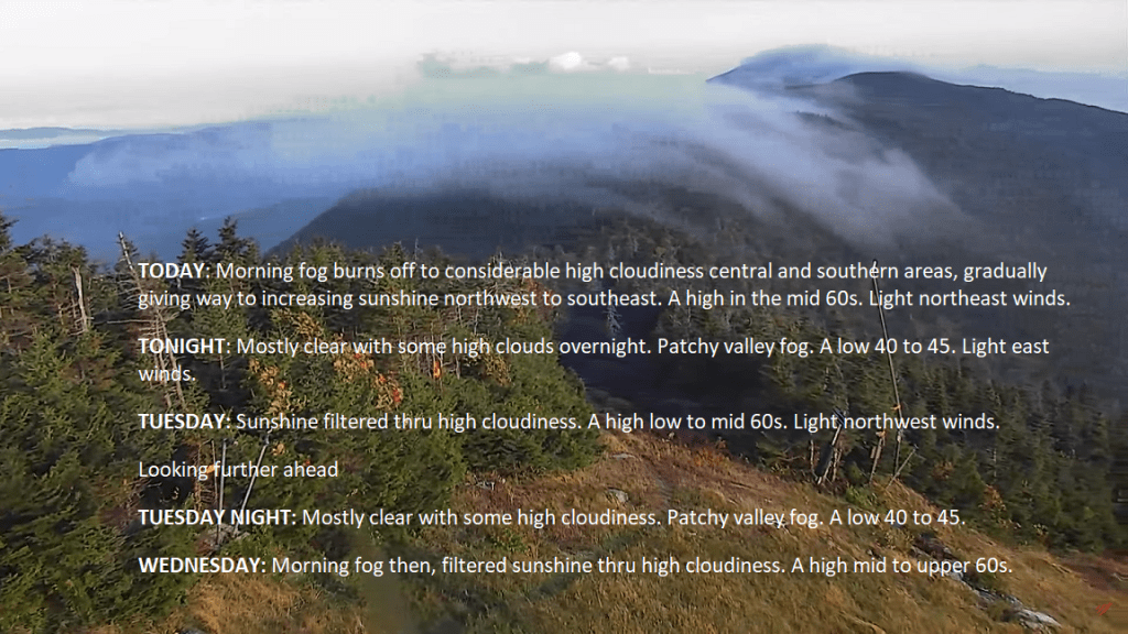
TODAY: Morning fog burns off to considerable high cloudiness central and southern areas, gradually giving way to increasing sunshine northwest to southeast. A high in the mid 60s. Light northeast winds.
TONIGHT: Mostly clear with some high clouds overnight. Patchy valley fog. A low 40 to 45. Light east winds.
TUESDAY: Sunshine filtered thru high cloudiness. A high low to mid 60s. Light northwest winds.

Looking further ahead
TUESDAY NIGHT: Mostly clear with some high cloudiness. Patchy valley fog. A low 40 to 45.
WEDNESDAY: Morning fog then, filtered sunshine thru high cloudiness. A high mid to upper 60s.

THURSDAY: Morning fog then mostly sunny with a few high clouds.A low 40 to 45. A high mid to upper 60s.
FRIDAY: Variable high cloudiness continued fair and dry. A low low to mid 60s. A high near 70.
SATURDAY: Mostly sunny after morning fog. A low around 45. A high 70 to 75.

SUNDAY: Bright sunshine. A low around 45. A high pushing near 75.
Average lows upper 30s to mid 40s. Average highs 60 to 65.
Admin: off Wednesday afternoon & Thursday.

RH/9-25 forecast][end]
Foggy mornings and sunshine filtered thru high clouds will be the rule for the entire week and going into the weekend. #Dry #GreenMountains #Vermont #BlockingHigh Pressure
Not much to see here with this test.

TONIGHT: Autumnal Equinox 2:49 AM Fair with high overcast. A low 45 to 50. Light southeast winds.
TOMORROW: High cloudiness thickening up in the afternoon. Just a little cooler. A high upper 50s central and southern areas to mid-60s northern areas. Light east winds.
SATURDAY NIGHT: A few brief showers or sprinkles possible Barre-Montpelier area south. A low in the lower 50s. Little wind.

SUNDAY: Gray. Chance for showers southern areas followed by gradual clearing late. A high 60 to 65. Light northeast breeze.
Looking further ahead

SUNDAY NIGHT: Mostly clear.Considerable valley fog.A low 45 to 50.
MONDAY: Lots of clouds with intervals of sun in northern areas. A high mid to upper 60s.
TUESDAY: Sunshine with a few high clouds. A low 45 to 50. A high near 65
WEDNESDAY: Bright and sunny. A low upper 30s to mid-40s. A high 65 to 70. Potentially several more dry days follow…
Average lows in the low to mid 40s. Average highs mid to upper 60s.
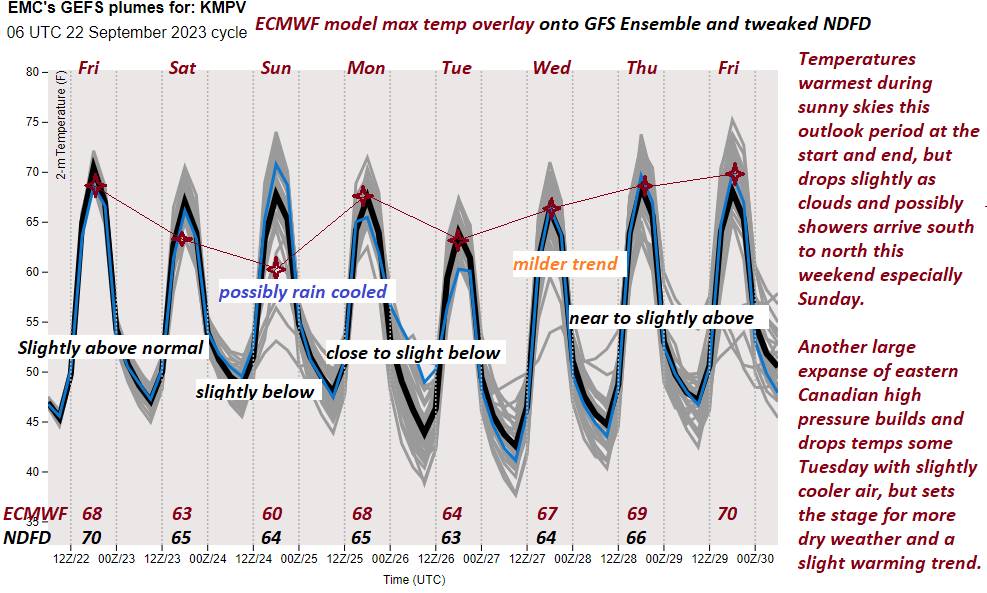
RH/9-22 forecast][end]

TODAY: Morning valley fog, then hazy sunshine with high cloudiness developing late. A high near 70. Light southeast breeze.

Autumnal Equinox 2:49 AM
TONIGHT: Fair with high overcast. A low 45 to 50. Light southeast winds.
SATURDAY: High cloudiness thickening up in the afternoon. Just a little cooler. A high upper 50s central and southern areas to mid-60s northern areas. Light east winds.

Looking further ahead
SATURDAY NIGHT: Scattered showers or sprinkles southern Vermont. A low 45 to 50
SUNDAY: Gray. Chance for showers southern and central areas, remaining dry far north. A high ranging upper 50s southern areas, to mid-60s north.

MONDAY: Lots of clouds with intervals of sun in northern areas. Maybe an afternoon shower. A low 45 to 50. A high mid to upper 60s.
TUESDAY: Sunshine with a few afternoon clouds. A low 45 to 50. A high near 65
WEDNESDAY: Bright and sunny. A low upper 30s to mid-40s. A high 65 to 70.
Average lows in the low to mid 40s. Average highs mid to upper 60s.
RH/9-22 forecast][end]
