Updated Thursday Morning Forecast — October 19th, 2023

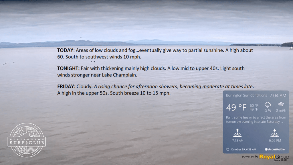
TODAY: Areas of low clouds and fog…eventually give way to partial sunshine. A high of about 60. South to southwest winds 10 mph.

TONIGHT: Fair with thickening mainly high clouds. A low mid to upper 40s. Light south winds are stronger near Lake Champlain.

FRIDAY: Cloudy. A rising chance for afternoon showers, becoming moderate at times late. A high in the upper 50s. South breeze 10 to 15 mph.

Looking further ahead

FRIDAY NIGHT: Cloudy. Showers are moderate to briefly heavy at times. A low near 50.

SATURDAY: Gray & wet. Showers, or periods of rain are likely, moderate to heavy at times. Areas of fog. A high in the mid-50s.

SUNDAY: Gray, and turning blustery. Good chance for showers to continue. Temperatures gradually falling into the upper 40s.

MONDAY: Clouds giving way to periods of sun. A low in the upper 30s. A high 45 to 50.

TUESDAY: Patchy valley fog, burns off to filtered sunshine thru high clouds. A low around 32. A high 50 to 55.

Average lows are in the low to mid-30s. Average highs in the low to mid-50s.

RH/10-18 forecast][end]

Updated Wednesday Evening Forecast — October 18th, 2023

TONIGHT: Becoming mostly clear.Patchy valley fog.A low in the upper 30s. Light south winds.

TOMORROW: Morning fog then lots of sunshine with a few more afternoon clouds. A high near 60. South to southwest winds 10 mph.

THURSDAY NIGHT: Fair with increasing clouds. A low around 45. Light south winds are stronger near Lake Champlain.

FRIDAY: Considerable cloudiness. A threat of a sprinkle in the afternoon. A high in the low 60s. South breeze 10 to 15 mph.

Looking further ahead

FRIDAY NIGHT: Cloudy. Showers are likely…moderate at times. A low near 50.

SATURDAY: Gray & damp. Showers likely. Areas of fog. A high mid to upper 50s.

SUNDAY: Gray, and turning blustery. There is a good chance for periods of rain or showers to continue. A low 40 to 45. A high 50 to 55.

MONDAY: Clouds gradually give way to intervals of sun. A low in the upper 30s. A high near 50.

Average lows in the low to mid-30s. Average highs in the low to mid-50s.

RH/10-18 forecast][end]

Updated Wednesday Morning Forecast — October 18th, 2023

TODAY: Clouds with intervals of sun developing. An isolated sprinkle is still possible to the north. A high in the middle 50s. Light southwest winds.

TONIGHT: Mostly clear. Patchy valley fog.A low in the upper 30s. Light south winds.

THURSDAY: Morning fog then lots of sunshine with a few more afternoon clouds. A high near 60. South to southwest winds 10 mph.

Looking further ahead

THURSDAY NIGHT: Fair with increasing clouds. A low around 45.

FRIDAY: Mostly cloudy. A threat for a sprinkle in the afternoon with showers likely after dark…moderate at times. A high in the low 60s.

SATURDAY: Gray & damp. Showers likely. Areas of fog. A low near 50. A high mid to upper 50s.

SUNDAY: Overcast, and turning blustery. There is a good chance for periods of rain or showers to continue. A low 40 to 45. A high 50 to 55.

MONDAY: Morning clouds then partly to mostly sunny in the afternoon. A low in the upper 30s. A high near 50.

Average lows are in the low to mid-30s. Average highs in the low to mid-50s.

RH/10-18 forecast][end]

Updated Tuesday Evening Forecast — October 17th, 2023

TONIGHT: Partly to mostly cloudy. A low upper 30s around 40. Little wind.

TOMORROW: Intervals of sun. A high 55 to 60. Light southwest winds.

WEDNESDAY NIGHT: Mostly clear.Patchy valley fog.A low in the upper 30s. Light south winds.

THURSDAY: Morning fog then lots of sunshine with a few more afternoon clouds. A high around 60. South to southwest winds 10 mph.

Looking further ahead

THURSDAY NIGHT: Fair with increasing clouds. A low around 45.

FRIDAY: Mostly cloudy. A threat for a sprinkle. A high in the low 60s.

SATURDAY: Mainly gray. Good chance for showers arriving later on. A low near 50. The high in the upper 50s.

SUNDAY: Mainly gray, turning blustery. Chance for showers. A low 40 to 45. A high 50 to 55.

MONDAY: Becoming partly to mostly sunny. A low around 35. A high 45 to 50.

Average lows in the low to mid-30s. Average highs in the low to mid-50s.

RH/10-17 forecast][end]

Updated Tuesday Morning Forecast — October 17th, 2023

TODAY: Lots of clouds with a few breaks of sun. Widely scattered light showers especially afternoon. A high near 55. Light northwest winds.

TONIGHT: Becoming partly cloudy. A low upper 30s around 40. Little wind.

WEDNESDAY: Clouds giving way to partial afternoon sun. A high 55 to 60. Light southwest winds.

Looking further ahead

WEDNESDAY NIGHT: Mostly clear.A low in the upper 30s.

THURSDAY: Morning sun followed by some afternoon clouds. A high around 60.

FRIDAY: Thickening mainly high clouds. A threat for a few sprinkles. A low around 45. A high in the low 60s.

SATURDAY: Gray with a few breaks of sunshine in western areas. Chance for showers spreading northward. A low near 50. The high upper 50s.

SUNDAY: Mainly gray. Chance for showers or periods of rain. Becoming blustery late. A low 40 to 45. A high

50 to 55.

MONDAY: Becoming partly to mostly sunny. A low around 35. A high 45 to 50.

Average lows are in the low to mid-30s. Average highs in the low to mid-50s.

RH/10-17 forecast][end]