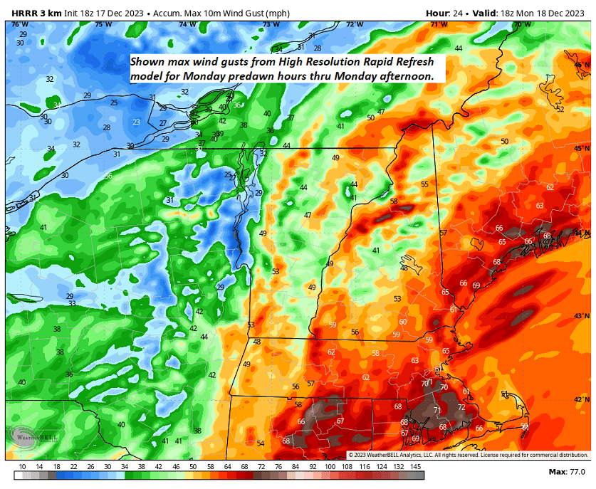
The higher resolution modeling for tomorrow Monday shows the max wind gusts. Wind-blown rain and yes mild temps with lots of snow melt incoming.


TONIGHT: Overcast.Rain…this evening, mainly light with areas of dense fog developing. A few leftover sprinkles overnight. Watch for icy spots. A low about 32 to 35. Light south winds.
TOMORROW: Mainly gray. A few light rain showers in northern areas. A high near 40. Little wind.
SATURDAY NIGHT: Widely scattered light rain showers with pockets of freezing rain & possible slick travel northern tier regions. A low in the low 30s.
SUNDAY: Clouds with a break or two of sun. Rain likely in the afternoon…transitioning to wet snow late across upper mountain slopes. A high in the upper 30s.
Looking further ahead

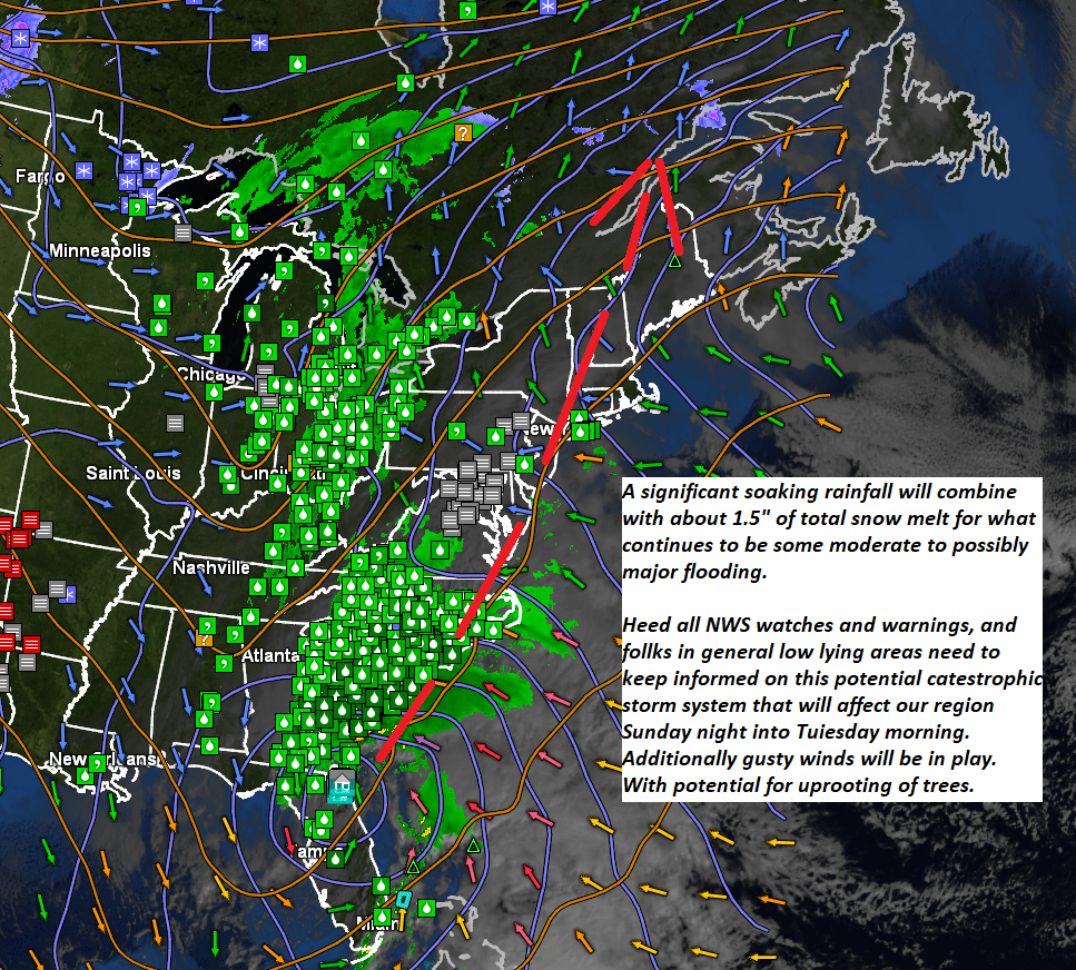
SUNDAY NIGHT: Overcast. Rain going over to accumulating wet snow down to valley floors…moderate to heavy at times with several inches likely.. A low near 32.
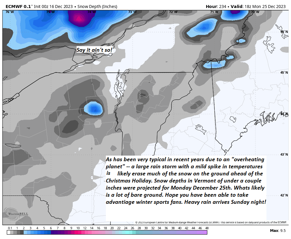
MONDAY: Gray. Good chance for occasional light accumulating snow showers or flurries. A high 32 to 35.
TUESDAY: Intervals of sun after a morning mountain flurry. Lows 10 to 15. Highs in the mid-20s.

WEDNESDAY: High cloudiness but fair and cold. A low in the single digits above zero. A high 20 to 25.
Average lows upper teens to mid-20s. Average highs are mid-30s to around 40.
Note – off for the next two weeks….
RH/12-1forecast][end]
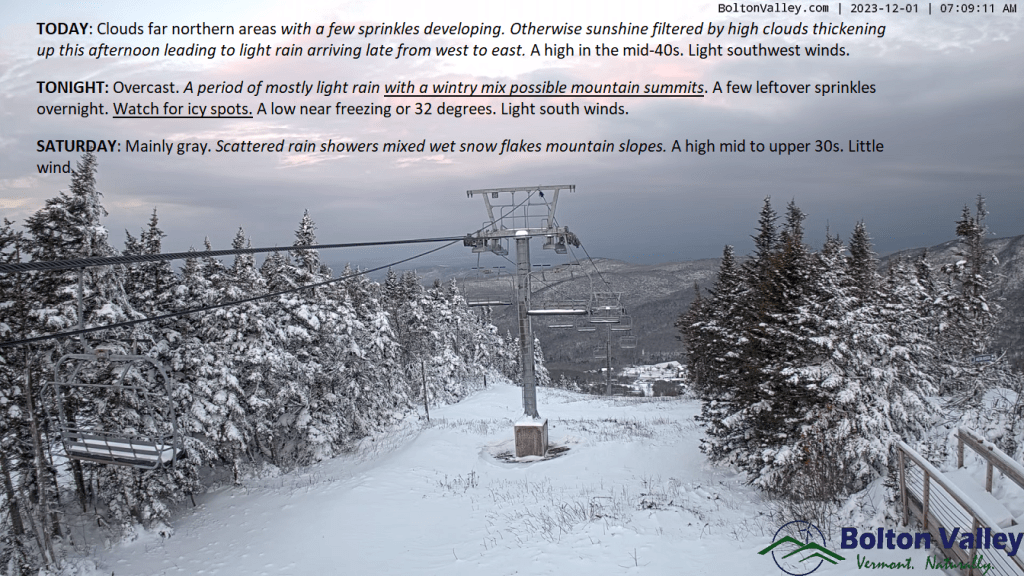
TODAY: Clouds in far northern areas with a few sprinkles developing. Otherwise, sunshine filtered by high clouds thickening up this afternoon leading to light rain arriving late from west to east. A high in the mid-40s. Light southwest winds.
TONIGHT: Overcast.A period of mostly light rain with a wintry mix possible mountain summits. A few leftover sprinkles overnight. Watch for icy spots.A low near freezing or 32 degrees. Light south winds.
SATURDAY: Mainly gray. Scattered rain showers mixed wet snow flakes mountain slopes. A high mid to upper 30s. Little wind.
Looking further ahead
SATURDAY NIGHT: Widely scattered light rain showers with pockets of freezing rain & possible slick travel northern tier regions. A low 32 to 35.
SUNDAY: Clouds with a break or two of sun. Rain showers likely…with wet snow developing late across mountains slopes. A high in the mid-30s.
SUNDAY NIGHT: Overcast. Good chance for rain transitioning to accumulating wet snow. A few to several inches possible above valley floors especially in southern and central areas. A low around 30.
MONDAY: Gray. Good chance for occasional light accumulating snow showers or flurries. Temperatures near 32 degrees falling gradually falling thru the 20s.
TUESDAY: Intervals of sun after a morning flurry. Lows 15 to 25. Highs mid to upper 20s.
Average lows upper teens to mid-20s. Average highs mid-30s to around 40.
RH/12-1forecast][end]
TONIGHT: Fair with high clouds. An evening low around 32. Southwest winds 10 mph stronger near Lake Champlain.
TOMORROW: Becoming mostly cloudy but milder. A few sprinkles far north, give way to periods of light rain later in the afternoon. A high pushing into the mid-40s. Light southwest winds.
FRIDAY NIGHT: Overcast.A period of light rain with a wintry mix above 1500 ft. exiting to isolated leftover sprinkles around midnight. Watch for icy spots. A low 32 to 35. Light south winds.
SATURDAY: Mainly gray. Scattered rain showers. A high mid to upper 30s. Little wind.
Looking further ahead
SATURDAY NIGHT: Widely scattered light rain showers with pockets of freezing rain with slick travel. A low around 32.
SUNDAY: Clouds with a break or two of sun. Chance for rain showers or a wintry mix mainly higher terrain. A high in the mid to upper 30s.
SUNDAY NIGHT: Overcast. Chance for rain changing to accumulating wet snow, possibly significant. A low near 30.
MONDAY: Gray. Chance for accumulating wet snow with significant amounts in the morning tapering to scattered flurries in the afternoon. Temperatures near 32 degrees falling into the 20s late.
TUESDAY: Partly sunny. Lows 15 to 25. Highs mid to upper 20s.
Average lows upper teens to mid-20s. Average highs mid-30s to around 40.
RH/11-30forecast][end]
TODAY: Early cloudiness gives way to sunshine, with some high clouds this afternoon. Warming trend. A high upper 30s to near 40. South to southwest winds 10 mph, stronger near Lake Champlain.
TONIGHT: Fair with high cloudiness.An evening low around 32. South to southwest winds 10 mph stronger near the lake.
FRIDAY: Thickening clouds & milder. Isolated rain showers far north, gives way to periods of light rain later in the afternoon. A high pushing to near 45. Light southwest winds.
Looking further ahead

FRIDAY NIGHT: Overcast.A periods of light rain likely in the evening with a with a wintry mix higher elevations exiting to isolated leftover sprinkles.Watch for icy spots overnight. A low 30 to 35.
SATURDAY: Mainly gray. Scattered rain showers. A high mid to upper 30s.

SUNDAY: Clouds with a break or two of sun. Chance for rain showers or a wintry mix mainly higher terrain. A low around 32. A high in the mid to upper 30s.
MONDAY: Overcast. Chance for accumulating wet snow possibly moderate to heavy at times with significant amounts tapering to light snow showers or flurries in the afternoon. Temperatures near 32 degrees falling into the 20sd late.
TUESDAY: Partly sunny. Lows 15 to 25. Highs mid to upper 20s.
Average lows are in the upper teens to mid-20s. Average highs mid-30s to around 40.
RH/11-29forecast][end]
