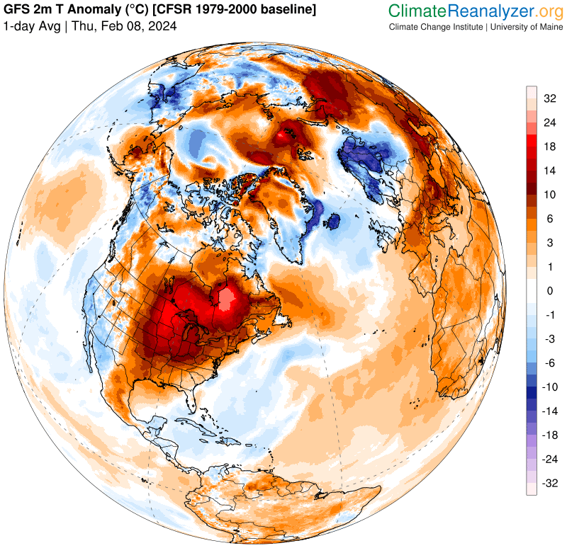
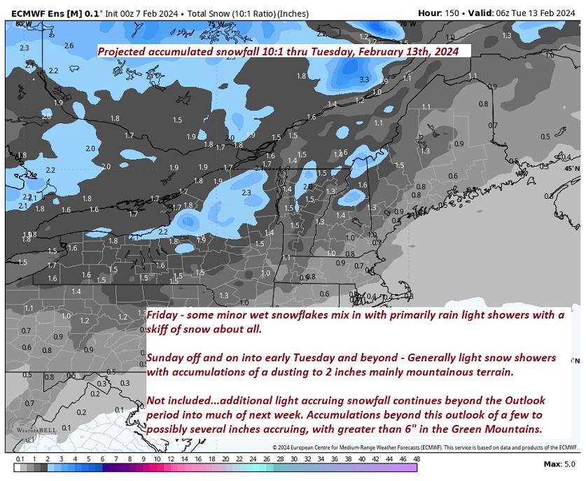
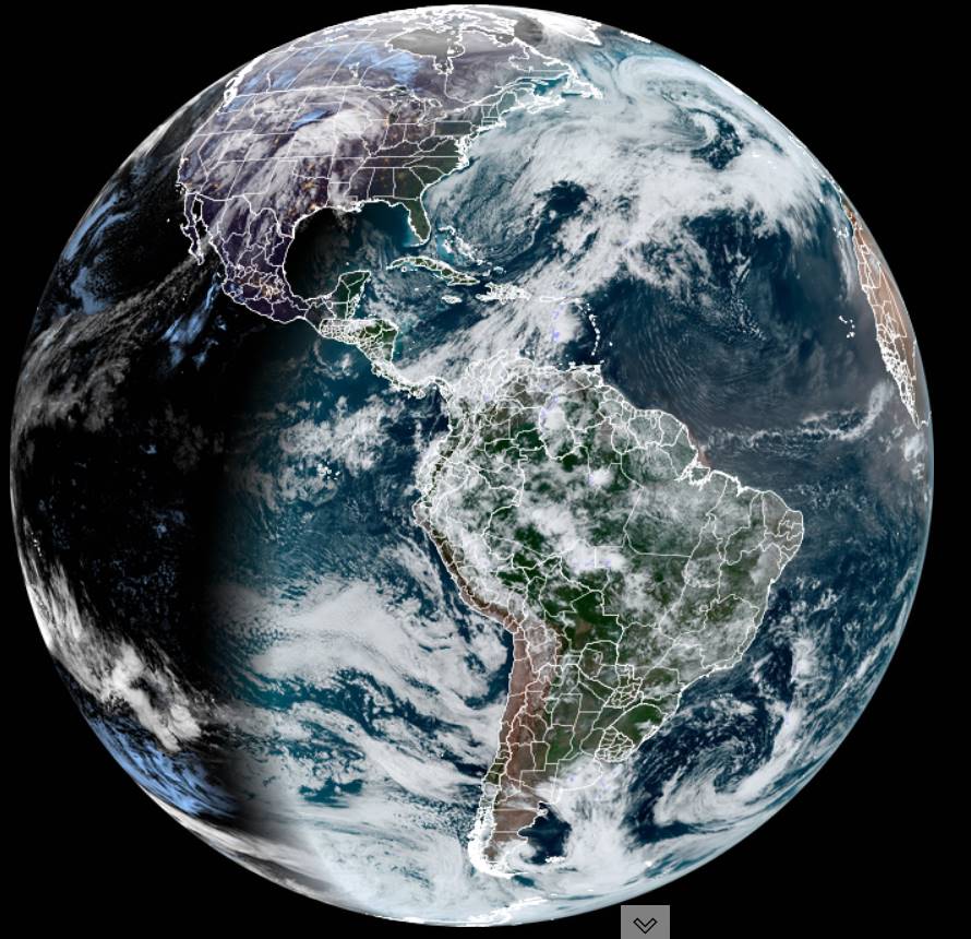
The southern sub-tropical jet stream will supply plenty of moisture pushing north into southern New England but largely passing to the south of much of Vermont. Some light accumulations for southerly areas, but 5-12″ snowfall southern New England…


TONIGHT: Mostly clear for a time this evening then clouding up. A couple showers developing northern areas overnight.A low in the mid-30s. South winds 10 mph.
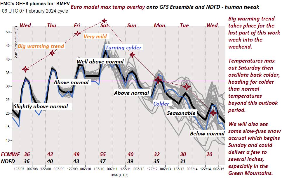
TOMORROW: Rain showers becoming likely intervals of sun & mild. A high around 50. Light southwest winds, stronger near Lake Champlain.
SATURDAY NIGHT: Lots of clouds. Scattered leftover rain showers drying up.A low in the mid-30s. Winds becoming westerly 10 mph.
SUNDAY: Considerable cloudiness. Cooling trend begins. Scattered wet snow showers or flurries especially northern Green Mountains. A high 35 to 40. Northwest winds 10 mph.
Looking further ahead
SUNDAY NIGHT: Mostly cloudy.A low 25 to 30.
MONDAY: Mainly cloudy. A stray flurry northern areas. A high 32 to 35.
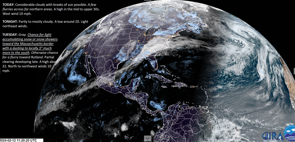
TUESDAY: Gray. Chance for accumulating snow southern areas, and minor snowfall central areas exiting in the afternoon. Partial late afternoon sun. A low in the low 20s. A high about 30.
WEDNESDAY: Mostly sunny. Lows in the teens. Highs 20 to 25.

Average lows single digits to low teens. Average highs mid-20s to lower 30s.
RH/2-9forecast][end]
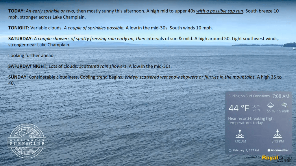
TODAY: An early sprinkle or two, then mostly sunny this afternoon. A high mid to upper 40s with a possible sap run. South breeze 10 mph. stronger across Lake Champlain.
TONIGHT: Variable clouds. A couple of sprinkles possible.A low in the mid-30s. South winds 10 mph.
SATURDAY: A couple showers of spotty freezing rain early on, then intervals of sun & mild. A high around 50. Light southwest winds, stronger near Lake Champlain.
Looking further ahead
SATURDAY NIGHT: Lots of clouds. Scattered rain showers.A low in the mid-30s.
SUNDAY: Considerable cloudiness. Cooling trend begins. Widely scattered wet snow showers or flurries in the mountains. A high 35 to 40.
MONDAY: Mainly cloudy. Slight chance for a mountain flurries. A low 25 to 30. A high 32 to 35.
TUESDAY: Widely scattered flurries with a chance for accumulating snow far southern areas. Partial afternoon sun. A low in the low 20s. A high about 30.
WEDNESDAY: Mostly sunny. Lows in the teens. Highs 20 to 25.
Average lows single digits to low teens. Average highs mid-20s to lower 30s.
RH/2-9forecast][end]
TONIGHT: Increasing & thickening high clouds. An isolated sprinkle or wet snow flake near the Quebec border overnight. A low ranging from the upper 20s to low 30s. Light southeast winds stronger across Lake Champlain.
TOMORROW: Scattered sprinkles across northern areas early giving way to mostly sunny skies. A high mid to upper 40s with a possible sap run. South breeze 10 mph.
FRIDAY NIGHT: Variably cloudy with a few passing showers.A low in the mid-30s. South winds 10 mph.
SATURDAY: A couple showers or spotty freezing rain early on, then intervals of sun & mild. A high in the upper 40s to near 50. Light southwest winds.
Looking further ahead
SATURDAY NIGHT: Lots of clouds. Scattered rain showers.A low in the mid-30s.
SUNDAY: Considerable cloudiness. Cooling trend begins. Scattered wet snow showers mixed with rain valleys. A high near 40.
MONDAY: Considerable cloudiness. A rising chance for light accumulating snow showers or flurries. A low
25 to 30. A high 32 to 35.
TUESDAY: Cloudy. A chance for snow or snow showers early, with accumulation of a few inches possible southern Green Mountains. Partial sunshine later on.
Average lows single digits to low teens. Average highs mid-20s to lower 30s.
RH/2-8forecast][end]
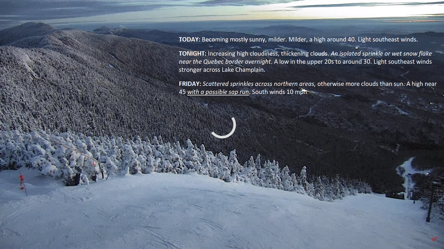
TODAY: Becoming mostly sunny, milder. Milder, a high around 40. Light southeast winds.
TONIGHT: Increasing high cloudiness, thickening clouds. An isolated sprinkle or wet snow flake near the Quebec border overnight. A low in the upper 20s to around 30. Light southeast winds stronger across Lake Champlain.
FRIDAY: Scattered sprinkles across northern areas, otherwise more clouds than sun. A high near 45 with a possible sap run. South winds 10 mph
Looking further ahead
FRIDAY NIGHT: Variably cloudy with a chance for a sprinkle.A low in the mid-30s.
SATURDAY: Chance for few rain showers early on, then partly to mostly sunny & mild. A high in the upper 40s to near 50.
SUNDAY: Considerable cloudiness. Scattered rain & wet snow showers. A low 32 to 35. A high near 40.
MONDAY: Considerable cloudiness. A rising chance for light accumulating snow showers or flurries. A low
25 to 30. A high 32 to 35.
TUESDAY: Cloudy. A chance for snow or snow showers early, with accumulation of a few inches possible southern Green Mountains. Partial sunshine later on.
Average lows single digits to low teens. Average highs mid-20s to lower 30s.
RH/2-8forecast][end]
TONIGHT: Early evening clouds then mostly clear. A low in the upper teens. Little wind.
TOMORROW: Mostly sunny and milder. Milder, a high near 40. Light southeast winds.
THURSDAY NIGHT: Thickening clouds. Maybe a sprinkle or wet snow flake or two. A low in the upper 20s. Light southeast winds stronger across Lake Champlain.
FRIDAY: Scattered sprinkles, otherwise more clouds than sun. A high near 45. South winds 10 mph
Looking further ahead
FRIDAY NIGHT: Variably cloudy with a chance for a sprinkle.A low in the mid-30s.
SATURDAY: Chance for few rain showers early on, then partly to mostly sunny & mild. A high in the upper 40s.
SUNDAY: Considerable cloudiness. Scattered rain & wet snow showers. A low 32 to 35. A high about 40.
MONDAY: Mainly gray. A rising chance for light accumulating snow showers or flurries. A low 25 to 30. A high 32 to 35.
Average lows single digits to low teens. Average highs mid-20s to lower 30s.
RH/2-6forecast][end]
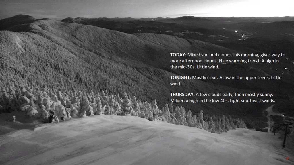
TODAY: Mixed sun and clouds this morning, gives way to more afternoon clouds. Nice warming trend. A high in the mid-30s. Little wind.
TONIGHT: Mostly clear. A low in the upper teens. Little wind.
THURSDAY: A few clouds early, then mostly sunny. Milder, a high in the low 40s. Light southeast winds.
Looking further ahead
THURSDAY NIGHT: Mostly cloudy. Maybe a wet snow flake or two. A low in the upper 20s.
FRIDAY: Scattered sprinkles or light rain showers, otherwise mainly cloudy. A high near 45.
SATURDAY: Partly sunny & mild. Chance for rain showers in the afternoon. A low in the mid-30s. A high pushing to near 50 degrees.
SUNDAY: Lots of clouds. Isolated brief flurry or two northern areas. A low 32 to 35. A high about 40.
Average lows single digits to low teens. Average highs mid-20s to lower 30s.
RH/2-6forecast][end]