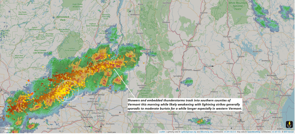
Some rumblings across southern 4 counties of Vermont this morning. Storms likely more elevated without much if any wind and just lightning in sparse to moderate bursts this morning as the elevated instability weakens while tracking east.


TONIGHT: Partly to mostly cloudy. Rising chance for showers late toward daybreak. A low 40 to 45. Light east winds.
TOMORROW: Considerable clouds. Showers likely, western and northern areas…moderate at times maybe a rumble of thunder. A high mid-50s to low 60s western Vermont valleys. Light southeast winds.
TUESDAY NIGHT: Cloudy.Showers, moderate at times, exiting after midnight. A low in the mid-40s. Light southeast winds.

WEDNESDAY: Mainly gray with a threat for a few misty sprinkles, with a few breaks of afternoon sun.A high in near 60. Winds light and variable.
Looking further ahead
WEDNESDAY NIGHT: Lots of clouds, a rising chance for showers.A low 45 to 50.

THURSDAY: Clouds, a few breaks of sunshine. Chance for lingering showers. A high near 60.
FRIDAY: Sunshine filtered by high cloudiness with more clouds in the afternoon. A low 45 to 50. A high near 65.
SATURDAY: Considerable clouds. A rising chance for rain showers toward evening. A low in the mid-40s. A high in the lower 60s.

Average lows low 30s to near 40. Average highs upper 50s to mid-60s.
Start of meteorological summer June 6th
RH/4-29forecast][end]
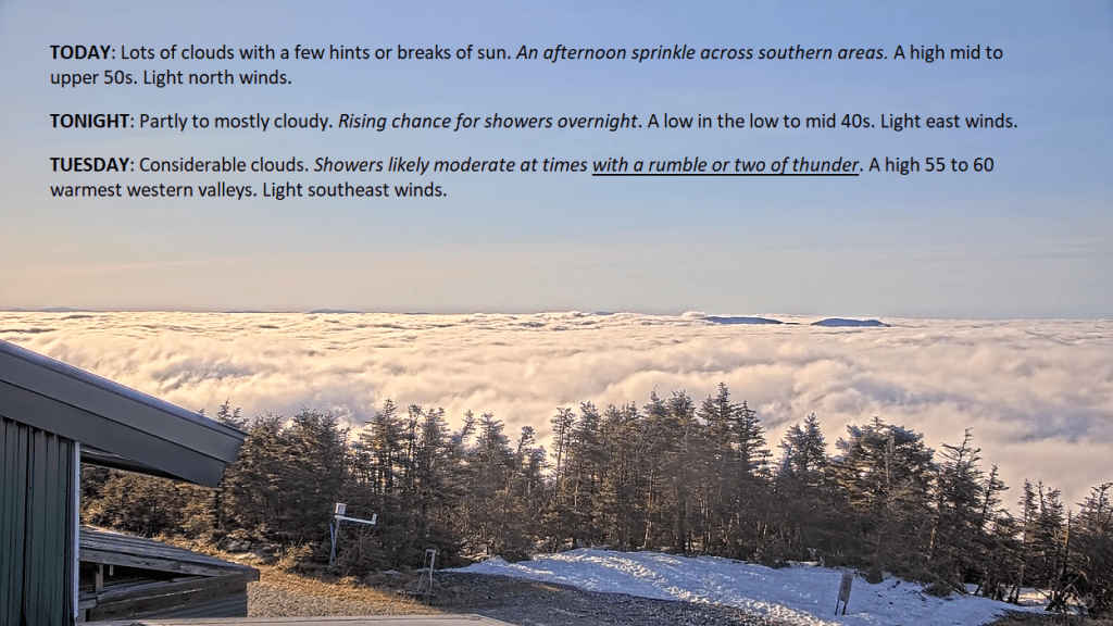
TODAY: Lots of clouds with a few hints or breaks of sun. An afternoon sprinkle across southern areas. A high mid to upper 50s. Light north winds.
TONIGHT: Partly to mostly cloudy. Rising chance for showers overnight. A low in the low to mid 40s. Light east winds.
TUESDAY: Considerable clouds. Showers likely moderate at times with a rumble or two of thunder. A high 55 to 60 warmest western valleys. Light southeast winds.
Looking further ahead
TUESDAY NIGHT: Mainly cloudy.Scattered showers exiting in the evening. A low in the mid-40s.
WEDNESDAY: Mainly gray patchy drizzle early, with a few breaks of afternoon sun.A high in the upper 50s around 60.
THURSDAY: Clouds, a few breaks of sunshine. Widely scattered showers. A low around 45. A high around 65.
FRIDAY: Sunshine filtered by high cloudiness. A low 45 to 50. A high around 65.
Average lows low 30s to near 40. Average highs upper 50s to mid-60s.
Start of meteorological summer June 6th
RH/4-29forecast][end]
TONIGHT: Clear, moonlit and again frosty. A low around 25. Little wind.
TOMORROW: Tons of sunshine, and a little warmer. A high 50 to 55. Light north wind.
FRIDAY NIGHT: Clear & moonlit. A low in the upper 20s around 30. Light southeast wind.
SATURDAY: Brief morning sun, becoming filtered by increasing high clouds. A high in the low 60s. South breeze 10 mph.
Looking further ahead
SATURDAY NIGHT: Thickening clouds, leading to a rising chance for showers.A low 40 to 45.
SUNDAY: Isolated showers exit early to breaks of sun. Widely scattered showers and thunderstorms afternoon showers and thunderstorms northern areas. A high mid-60s.
MONDAY: Partly sunny. A low mid to upper 40s. A high upper 60s around 70.
TUESDAY: Mostly cloudy. Chance for showers, maybe an afternoon thunderstorm. A low in the lower 50s. A high in the 60s.
WEDNESDAY: Partly to mostly cloudy. Chance for a shower or storm late. A low 45 to 50. A high in the lower 70s.

Average lows upper 20s to mid-30s. Average highs mid-50s to around 60.
Start of meteorological summer June 6th
RH/4-24forecast][end]

No forecast Friday…
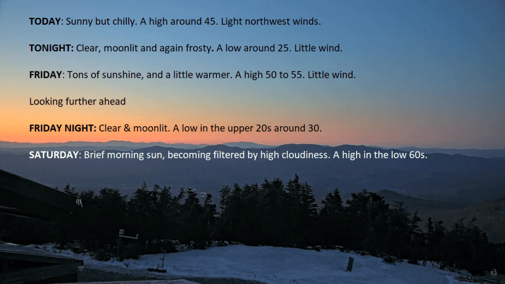
TODAY: Sunny but chilly. A high around 45. Light northwest winds.
TONIGHT: Clear, moonlit and again frosty. A low around 25. Little wind.
FRIDAY: Tons of sunshine, and a little warmer. A high 50 to 55. Little wind.

Looking further ahead
FRIDAY NIGHT: Clear & moonlit. A low in the upper 20s around 30.
SATURDAY: Brief morning sun, becoming filtered by high cloudiness. A high in the low 60s.
SUNDAY: Scattered rain showers in the morning otherwise lot of clouds with breaks of sun. Widely late afternoon showers and thunderstorms. A low 40 to 45. A high mid-60s.
MONDAY: More clouds than sun. An isolated shower or two. A low mid to upper 40s. A high upper 60s around 70.
TUESDAY: Mostly cloudy. Chance for showers, maybe an afternoon thunderstorm. A low in the lower 50s. A high in the 60s.
WEDNESDAY: Partly to mostly cloudy. Chance for a shower or storm late. A low 45 to 50. A high in the lower 70s.
Average lows upper 20s to mid-30s. Average highs mid-50s to around 60.
Start of meteorological summer June 6th
RH/4-24forecast][end]

TONIGHT: Clear, moonlit & cold.A low 20 to 25. Northwest winds 10 mph becoming light.
TOMORROW: Sunny but chilly. A high mid to upper 40s. Light northwest winds.
THURSDAY NIGHT: Clear, moonlit and again frosty. A low 25 to 30. Little wind.

FRIDAY: Tons of sunshine, and a little warmer. A high around 55. Little wind.
Looking further ahead
FRIDAY NIGHT: Clear & moonlit. A low around 32.

SATURDAY: High cloudiness thickening up late. A high in the low to mid 60s.
SUNDAY: Scattered rain showers in the morning otherwise mainly cloudy. A low 40 to 45. A high mid to upper 60s.
MONDAY: Lots of clouds with a few hints of sun. Chance for rain showers, A low mid to upper 40s. A high around 65.
TUESDAY: Mostly cloudy. Chance for showers, maybe an afternoon thunderstorm. A low 50 to 55. A high in the low 70s.

Average lows upper 20s to mid-30s. Average highs mid-50s to around 60.
Start of meteorological summer June 6th
RH/4-24forecast][end]
TODAY: Considerable cloudiness & turning blustery and sharply colder. Occasional rain showers, tailing off with a few wet snowflakes northern areas this afternoon. Partial late day sunshine develops. A mid-day high in the mid to upper 40s. Winds shifting to northwesterly 10 to 20 mph and gusty.
TONIGHT: Clear, moonlit & cold.A low 20 to 25. Light northwest winds.
THURSDAY: Sunny with a few high clouds. A high mid to upper 40s. Light northwest winds.
Looking further ahead
THURSDAY NIGHT: Mostly clear and moonlit. A low 25 to 30.
FRIDAY: Sunny with few high clouds. A high around 55.
SATURDAY: High cloudiness thickening up late. A morning low around 32. A high in the low to mid 60s.
SUNDAY: Scattered rain showers in the morning otherwise mainly cloudy. A low 40 to 45. A high mid to upper 60s.
MONDAY: Lots of clouds with a few hints of sun. Chance for rain showers, maybe an afternoon rumble of thunder. A low mid to upper 40s. A high around 65.
TUESDAY: Mostly cloudy. Chance for showers, maybe an afternoon thunderstorm. A low 50 to 55. A high in the low 70s.
Average lows upper 20s to mid-30s. Average highs mid-50s to around 60.
Start of meteorological summer June 6th
RH/4-24forecast][end]
