Updated Monday Morning Forecast — July 5th, 2021

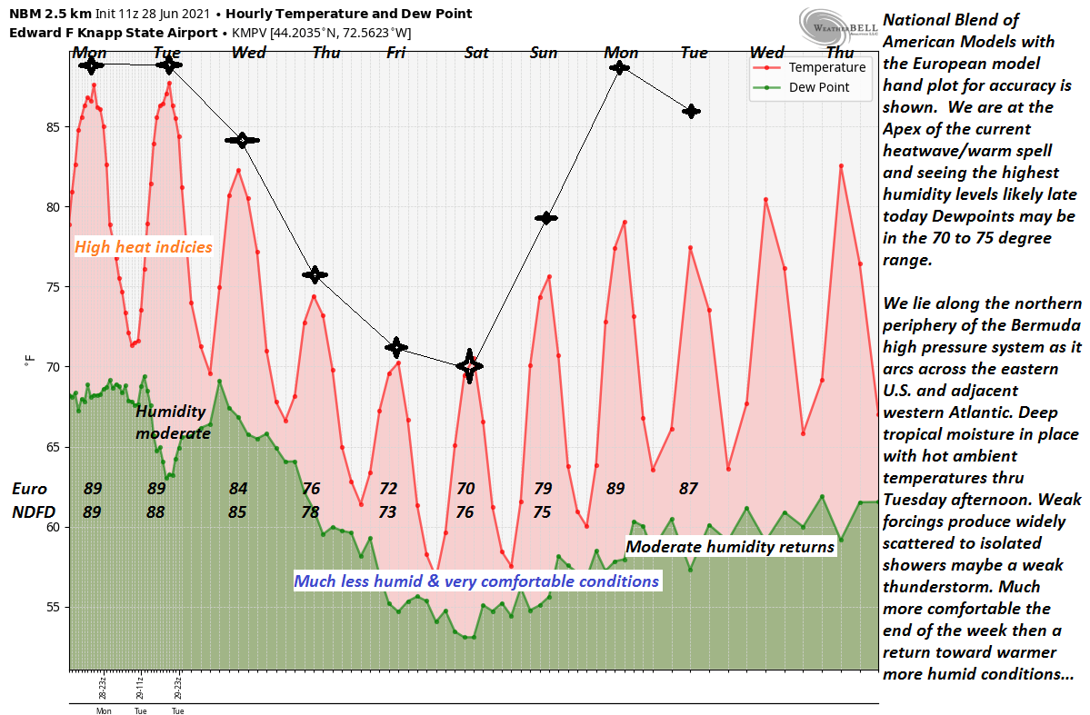
TODAY: Morning fog burns off, then filtered sunshine through high cloudiness this afternoon. A high mid to upper 70s. Light south breeze.

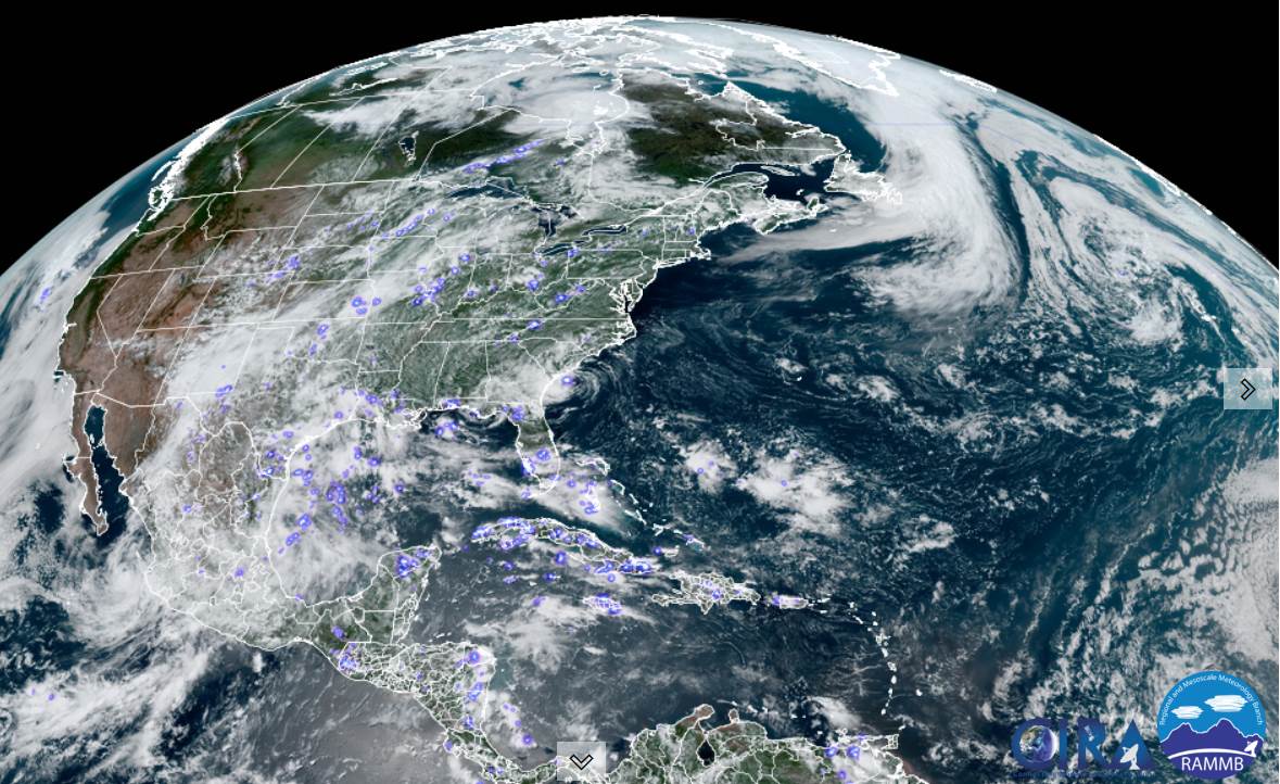
TONIGHT: Fair early then thickening clouds. A rising chance for showers and a few thunderstorms developing later this evening and overnight northern areas. A low 60 to 65. Light south to southeast winds stronger near Lake Champlain.

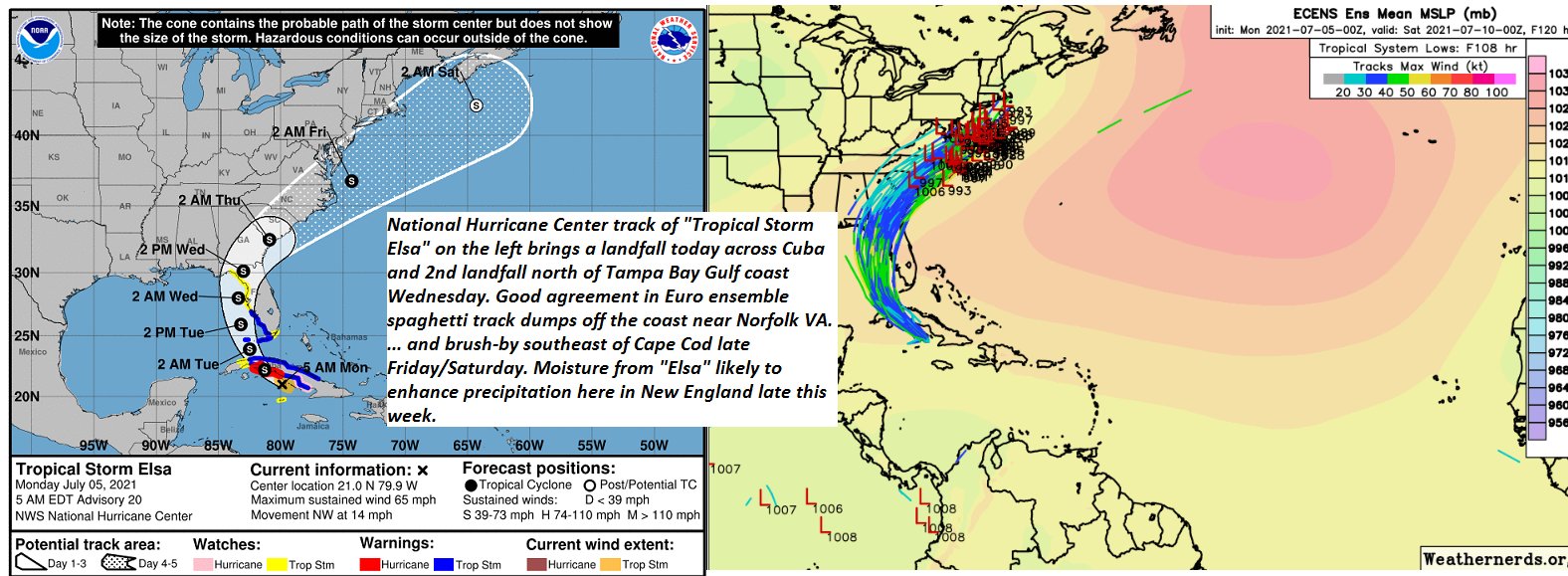
TUESDAY: Variably cloudy, humid. Widely scattered showers and thunderstorms, some maybe strong especially central and southern areas in the afternoon. A high 80 to 85. Southwest breeze 10 to 20 mph.

Looking further ahead…

TUESDAY NIGHT: A leftover evening shower or storm winding down, otherwise becoming partly cloudy. A low 60 to 65.

WEDENESDAY: Periods partial sunshine early then lots of afternoon clouds. A rising chance for showers, maybe a thunderstorm far southern areas. A high upper 70s to near 80.

THURSDAY: Considerable cloudiness. Chance for showers, possible late day thunderstorms heavy at times. A low 55 to 60. A high 70 to 75.

FRIDAY: Clouds, a few breaks of sun. Chance for showers, maybe a thunderstorm. A low around 60. A high around 75.

Average low 55 to 60. Average highs in the mid-70s to low 80s. .

Meteorological summer peaks approx. July 22nd based off local climatology.

RH/7-5forecast][end]

Updated Friday Evening Forecast — July 2nd, 2021

TONIGHT: Mostly cloudy continued damp. Scattered light showers/sprinkles areas of drizzle and fog. A low around 55.

Light east winds.

TOMORROW: Mainly gray, continued unseasonably cool. Lingering rain showers. A high 60 to 65. Light northeast winds.

SATURDAY NIGHT: Lots of clouds. Lingering light showers, areas of drizzle and fog. A low around 55. Little wind.

SUNDAY Independence Day: Clouds with occasional breaks of sun in the afternoon. Widely scattered rain showers. Still cool. A high mid to upper 60s. Light northeast winds.

Looking further ahead…

SUNDAY NIGHT: Clouds give way to partial clearing western areas. Cloudy otherwise, isolated to widely scattered rain showers especially southern areas. A low 50 to 55.

MONDAY: Considerable cloudiness with a few breaks of sun western areas. Isolated light showers/sprinkles southern/eastern areas. A high in the low to mid 70s

TUESDAY: Variably cloudy, muggy. Chance for showers and thunderstorms, some could be strong in the afternoon. A low 60 to 65. A high 80 to 85.

WEDENESDAY: Clouds with intervals of sun. Pleasant. A low mid-50s. A high around 75.

Average low 55 to 60. Average highs in the mid-70s to low 80s. .

Meteorological summer peaks approx. July 22nd based off local climatology.

RH/7-2forecast][end]

Updated Friday Morning Forecast — July 2nd, 2021

TODAY: Periods of rain, moderate at times. Otherwise gray, unseasonably cool. A high in the mid-60s. Light northeast winds.

TONIGHT: Mostly cloudy. Scattered showers with areas of drizzle and fog. A low around 55. Light east winds.

SATURDAY: Mainly gray, continued unseasonably cool. Lingering rain showers especially near the mountains. A high 60 to 65. Light northeast winds.

Looking further ahead…

SATURDAY NIGHT: Lots of clouds. Lingering light showers, areas of drizzle and fog. A low around 55.

SUNDAY Independence Day: Clouds with occasional breaks of sun in the afternoon. Scattered lingering showers. A risk of thunder southern areas. Still cool. A high mid to upper 60s.

MONDAY: Considerable cloudiness with a few breaks of sun western areas. Isolated light showers/sprinkles southern/eastern areas. A low 50 to 55. A high in the low to mid 70s

TUESDAY: Variably cloudy, muggy. Chance for showers and thunderstorms, some could be strong central and southern areas. A low 60 to 65. A high 80 to 85.

WEDENESDAY: Clouds with intervals of sun. Pleasant. A low mid-50s. A high around 75.

Average low 55 to 60. Average highs in the mid-70s to low 80s. .

Meteorological summer peaks approx. July 22nd based off local climatology.

RH/7-2forecast][end]

Updated Thursday Night Weather — July 1st, 2021

TONIGHT: Cloudy. Periods of rain or showers southern Vermont, spread north after midnight. A low near 60. Light northeasterly winds.

TOMORROW: Periods of rain or showers, moderate at times. Otherwise gray, unseasonably cool. A high in the mid-60s. Light northeast winds.

FRIDAY NIGHT: Mostly cloudy. Scattered showers with areas of drizzle and fog. A low around 55. Light east winds.

SATURDAY: Mainly gray, continued unseasonably cool. Lingering light shower activity especially near the mountains. A high in the mid-60s. Light northeast winds.

Looking further ahead…

SATURDAY NIGHT: Lots of clouds. Lingering light showers, areas of drizzle and fog. A low around 55

SUNDAY Independence Day: Considerable cloudiness with scattered showers. Still cool. A high 65 to 70.

MONDAY: Areas of low clouds & fog, then mixed clouds and sun. Isolated sprinkles southern areas. A low in the low 50s. A high around 75.

TUESDAY: Variably cloudy, muggy. Chance for afternoon showers and thunderstorms. A low in the low 60s. A high 80 to 85.

Average low 55 to 60. Average highs in the mid-70s to low 80s. .

Meteorological summer peaks approx. July 22nd based off local climatology.

RH/7-1forecast][end]

Updated Thursday morning Forecast — July 1st, 2021

TODAY: Lots of clouds & much less humid. An isolated brief shower or sprinkle toward southern areas. A high around 75. Light northwest winds.

TONIGHT: Overcast. Showers becoming likely after midnight. A low near 60. Light northeasterly winds.

FRIDAY: Overcast & gray. Unseasonably cool. Periods of rain or showers, moderate at times with a rumble of thunder possible. A high mid to upper 60s. Light northeast winds.

Looking further ahead…

FRIDAY NIGHT: Mostly cloudy. Scattered rain showers. A low around 55.

SATURDAY: Mostly cloudy & unseasonably cool. Scattered showers, mainly near the mountains. A high upper 60s to near 70.

SUNDAY Independence Day: Mostly cloudy. Chance for few sprinkles or light showers. A low around 55. A high in the upper 60s.

MONDAY: Mixed clouds and sun & pleasant. A low 50 to 55. A high 75 to 80.

Average low in the mid to upper 50s. Average highs in the mid-70s to low 80s.

Meteorological summer peaks approx. July 22nd based off local climatology.

RH/7-1forecast][end]

Updated Wednesday Night Forecast — June 30th, 2021

TONIGHT: Mostly cloudy. A few leftover showers…maybe a rumble of thunder far northern areas. Otherwise lots of clouds. A low in the mid-60s. Light southwest winds.

TOMORROW: Lots of clouds & much less humid. An isolated brief shower or sprinkle. A high around 75. Light northwest winds.

THURSDAY NIGHT: Overcast. A rising chance for showers after midnight southern and central areas. A low near 60. Light northeasterly winds.

FRIDAY: Overcast & gray. Unseasonably cool. Periods of rain, moderate at times. Maybe a thunderstorm. A high upper 60s to near 70. Light northeast winds.

Looking further ahead…

FRIDAY NIGHT: Mostly cloudy. A low around 55.

SATURDAY: Mostly cloudy & unseasonably cool. Scattered showers, mainly near the mountains. A high upper 60s to near 70.

SUNDAY Independence Day: Mostly cloudy. A low around 55. A high in the upper 60s.

MONDAY: Mixed clouds and sun & pleasant. A low 50 to 55. A high 75 to 80.

Average low in the mid to upper 50s. Average highs in the mid-70s to low 80s. .

Meteorological summer peaks approx. July 22nd based off local climatology.

RH/6-30forecast][end]

Updated Wednesday Morning forecast — June 30th, 2021

TODAY: Clouds with few intervals of morning sun. Showers…some moderate to heavy…with a few brief thunderstorms developing later this morning, northern areas. Thunderstorms, becoming strong to locally severe central and southern Vermont this afternoon. Very muggy. A high low to mid 80s. Southwest breeze 10 to 15 mph.

TONIGHT: Mostly cloudy. Evening showers & isolated thunderstorms, southern areas winding down. Otherwise cloudy. A low in the mid-60s. Light southwest winds.

THURSDAY: Lots of clouds & much less humid. Showers likely, maybe a rumble of thunder southern areas. A high mid to upper 70s. Light winds shifting to northwesterly.

Looking further ahead…

THURSDAY NIGHT: Cloudy. Lingering showers. A low near 60.

FRIDAY: Mainly gray. Periods of rain or showers…possibly moderate at times. Maybe rumble of thunder. A high just near 70.

SATURDAY: Clouds mixed with some intervals of sun. Scattered showers, mainly near the mountains. A low mid to upper 50s. A high in the low 70s.

SUNDAY Independence Day: Mixed sun and clouds after morning fog. A low in the low 50s. A high in the low to mid 70s.

MONDAY: Partly sunny & pleasant. A low 50 to 55. A high 75 to 80.

Average low in the mid to upper 50s. Average highs in the mid-70s to low 80s. .

Meteorological summer peaks approx. July 22nd based off local climatology.

RH/6-29forecast][end]

Updated Tuesday Evening Forecast — June 29th, 2021

TONIGHT: Partly cloudy. Sultry. Scattered evening showers diminish. More showers develop northern border areas…moderate at times. A low near 70. Light southwest winds.

TOMORROW: Clouds with intervals of sun. A good chance for showers and afternoon thunderstorms, one or two may be strong. Muggy with a high around 85. Southwest breeze 10 to 15 mph.

WEDNESDAY NIGHT: Mostly cloudy. Chance for evening showers or thunderstorms dissipating early. A low in the mid-60s. Light southwest winds.

THURSDAY: Lots of clouds & much less humid. Showers likely…moderate at times especially southern areas. A high mid to upper 70s. Light winds shifting to northwesterly.

Looking further ahead…

THURSDAY NIGHT: Cloudy. Good chance for rain or showers. A low in the upper 50s.

FRIDAY: Cloudy and gray. Periods of rain…possibly moderate at times central and southern areas. A high 70 to 75.

SATURDAY: Clouds mixed with some intervals of sun. Widely scattered light showers. A low mid to upper 50s. A high in the low 70s.

SUNDAY Independence Day: Morning clouds with a leftover rain shower possible…then more sun than clouds. A low mid to upper 50s. A high 70 to 75.

Average low in the mid to upper 50s. Average highs in the mid-70s to low 80s. .

Meteorological summer peaks approx. July 22nd based off local climatology.

RH/6-29forecast][end]

Updated Tuesday morning Forecast — June 29th, 2021

TODAY: More sunshine than clouds. Muggy. Isolated late afternoon showers and thunderstorms especially southern areas. A high mid-80s to around 90. Light southwest winds becoming northwesterly 10 mph this afternoon.

TONIGHT: Lots of clouds. Sultry. Scattered showers developing northern areas overnight. A low near 70. Light southwest winds.

WEDNESDAY: Clouds, with a few breaks of sun. A good chance for showers and afternoon thunderstorms, one or two may be strong. Muggy with a high around 85. Southwest breeze 10 to 15 mph.

Looking further ahead…

WEDNESDAY NIGHT: Variable clouds. Chance for a leftover evening shower or thunderstorm dissipating early. A low in the mid-60s.

THURSDAY: Mostly cloudy & much less humid. Good chance for showers…moderate at times especially southern areas. A high upper 70s to around 80.

FRIDAY: Cloudy and gray. Showers…possibly moderate at times especially central and southern areas. A low in the upper 50s. A high 70 to 75.

SATURDAY: Clouds mixed with some intervals of sun. Maybe a shower. A low near 60. A high 70 to 75.

SUNDAY Independence Day: Morning clouds with a leftover rain shower possible…then more sun than clouds. A low 55 to 60. A high 75 to 80.

Average low in the mid to upper 50s. Average highs in the mid-70s to low 80s. .

Meteorological summer peaks approx. July 22nd based off local climatology.

RH/6-29forecast][end]

Updated Monday Evening Forecast — June 28th, 2021

TOMORROW: Partly to mostly sunny, muggy. Widely scattered to isolated afternoon showers and thunderstorms especially central and southern areas. A high 85 to near 90. Light west to northwest winds.

TUESDAY NIGHT: Mostly cloudy. Sultry. A low upper 60s to near 70. Light southwest winds.

WEDNESDAY: Considerable cloudiness. A rising chance for late morning showers and afternoon thunderstorms. Muggy with a high around 85. Southwest breeze 10 to 15 mph.

Looking further ahead…

WEDNESDAY NIGHT: Variable clouds. Chance for a leftover shower or thunderstorm. A low in the mid-60s.

THURSDAY: Mostly cloudy & moderately humid. Chance for few rain showers especially southern areas. A high upper 70s to around 80.

FRIDAY: Considerable cloudiness. Chance for afternoon showers and isolated thunderstorms. A low in the low 60s. A high 70 to 75.

SATURDAY: Clouds mixed with some intervals of sun. Chance for a shower. A low upper 50s to around 60. A high upper 60s to around 70.

SUNDAY Independence Day: Morning clouds with a leftover rain shower possible…then more sun than clouds. A low 55 to 60. A high around 70.

Average low in the mid to upper 50s. Average highs in the mid-70s to low 80s. .

Meteorological summer peaks approx. July 22nd based off local climatology.

RH/6-28forecast][end]