Updated Friday morning forecast — April 14th, 2023

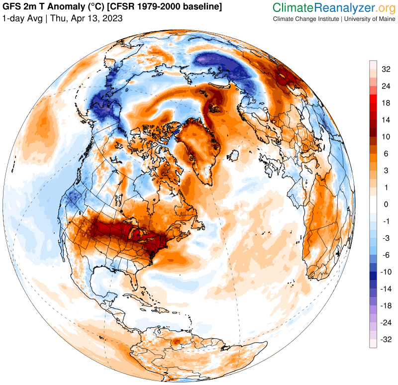
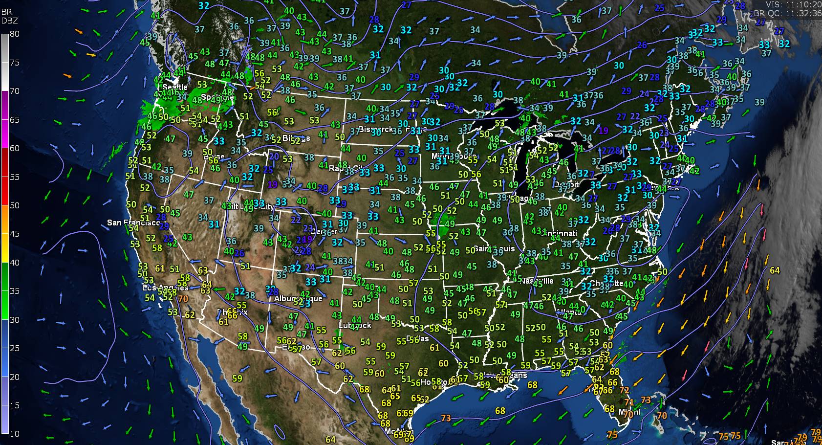
TODAY: A few high clouds otherwise lots of sunshine and a beauty. A high in the upper 70s. Light north winds.

TONIGHT: Mostly clear with high clouds. A low mid-40s to near 50. Light southeast winds.

SATURDAY: Filtered sun thru high cloudiness. Again very mild. A high low to mid 70s. Southeast breeze 10 mph.

Looking further ahead

SATURDAY NIGHT: Variable clouds. A chance of sprinkles, patchy drizzle southern areas after midnight. A low 45 to 50.

SUNDAY: Clouds with a few breaks of sunshine. A period of sprinkles patchy drizzle southern areas early. Partial clearing late. A high in the mid-60s.

MONDAY: Mainly gray. Good chance for rain showers…moderate at times later in the afternoon. A low 45 to 50. A high 55 to 60.

TUESDAY: Gray, damp but seasonal in temperature. Scattered rain showers with a few wet snow flakes returning upper mountain slopes. A low upper 30s to mid-40s. A high near 50.

WEDNESDAY: Considerable cloudiness. Chance for rain or wet snow showers with minor accumulation possible higher terrain. A low around 35. A high around 45.

Average lows 32 to 35. Average highs low to mid 50s.

Start of Meteorological summer June the 6th.

RH/4-14 forecast][end]

Updated Thursday Evening Forecast — April 13th, 2023

TONIGHT: Mostly clear with a few high clouds & mild.A low ranging 45 to 55. Light southwest winds.

TOMORROW: Lots of sunshine with a few high clouds. A high in the upper 70s. Wind becoming light and westerly.

FRIDAY NIGHT: Mostly clear with high clouds. A low in the 40s. Light southeast winds.

SATURDAY: Filtered sun thru high cloudiness. Again very mild. A high near 75. Southeast breeze 10 mph.

Looking further ahead

SATURDAY NIGHT: High cloudiness early, then variably cloudy. A low around 50.

SUNDAY: Some periods of sunshine northern areas. Thickening clouds southern areas with sprinkles or areas of drizzle. A high in the low to mid 60s.

MONDAY: Cloudy damp and cooler. Good chance for rain showers…moderate at times. A low mid to upper 40s. A high in the mid-50s.

TUESDAY: Gray, damp but seasonal in temperature. Scattered rain showers with wet snow flakes returning upper mountain slopes. A low 35 to 40. A high upper 40s near 50.

Average lows 30 to 35. Average highs low to mid 50s.

Start of Meteorological summer June the 6th.

RH/4-13 forecast][end]

Updated Thursday Morning Forecast — April 13th, 2023

TODAY: Pick of the week. Sunny, with a taste of early summer. A record high upper 70s to low 80s western Vermont low humidity levels and still high fire danger. West breeze 10 mph.

TONIGHT: Mostly clear with a few high clouds & mild.A low ranging 45 to 55. Light southwest winds.

FRIDAY: Lots of sunshine with a few high clouds. A high in the upper 70s. Wind becoming light and westerly.

Looking further ahead

FRIDAY NIGHT: Mostly clear. A low in the 40s.

SATURDAY: Filtered sun thru high cloudiness. Again very mild. A high near 75.

SUNDAY: Some periods of sunshine northern areas. Thickening clouds southern areas with a few spotty afternoon showers or sprinkles, areas of drizzle. A low around 50. A high 65 to 70.

MONDAY: Cloudy damp and cooler. Good chance for rain showers…moderate at times. A low around 45. A high 50 to 55.

TUESDAY: Gray, damp but seasonal in temperature. Scattered rain showers with wet snow flakes returning upper mountain slopes. A low upper 30s. A high 50 to 55.

Average lows 30 to 35. Average highs low to mid 50s.

Start of Meteorological summer June the 6th.

RH/4-13 forecast][end]

Updated Wednesday Evening Forecast — April 12th, 2023

TONIGHT: Partly cloudy. A threat for a brief sprinkle early. A low in the low to mid 40s. Winds becoming light from the south.

TOMORROW: Pick of the week. Sunny and well above normal in temperature. A near record high mid-70s to about 80 degrees. West breeze 10 mph.

THURSDAY NIGHT: Clear in the evening, then some high cloudiness, partially moonlit & mild.A low in the low to mid 50s. Light southwest winds.

FRIDAY: Lots of sunshine with a few high clouds. A high in the 70s. Wind becoming light and westerly.

Looking further ahead

FRIDAY NIGHT: Mostly clear. A low 45 to 50.

SATURDAY: Filtered sunshine thru high cloudiness. Remaining very mild. A near record high in the 70s.

SUNDAY: Considerable cloudiness. Chance for late day or evening shower. A low around 50. A high 65 to 70.

MONDAY: Cloudy. Chance for morning rain showers…briefly moderate at times. Damp and cooler. A low around 45. A high around 55.

Average lows 30 to 35. Average highs low to mid 50s.

Start of Meteorological summer arrives June 6th.

RH/4-12 forecast][end]

Updated Wednesday Morning Forecast — April 12th, 2023

TODAY: More clouds than sun. A high upper 50s. Northwest winds 10 to 25 mph.

TONIGHT: Occasional cloudy periods with threat for a sprinkle. A low ranging thru the 40s. Light southeast winds.

THURSDAY: Pick of the week. Mostly sunny well above normal in temperature. A near record high 75 to 80. West breeze 10 mph.

Looking further ahead

THURSDAY NIGHT: Mostly clear in the evening, then some high cloudiness, partially moonlit & mild.A low around 55.

FRIDAY: Lots of sunshine with a few high clouds. A high 70 to 75.

SATURDAY: Filtered sunshine thru high cloudiness. Remaining very mild. A low around 50. A near record high

75 to 80.

SUNDAY: Considerable cloudiness. Chance for late day or evening shower. A low around 50. A high 65 to 70.

MONDAY: Cloudy with some intervals of afternoon sunshine. Chance for morning rain showers…briefly moderate at times. Damp and cooler. A low around 45. A high around 55.

Average lows 30 to 35. Average highs low to mid 50s.

Start of Meteorological summer arrives June 6th.

RH/4-12 forecast][end]

Updated Tuesday Evening Forecast — April 11th, 2023

Red Flag Warning Champlain Valley, lower Connecticut River Valley expires this evening…

TONIGHT: Lots of clouds this evening. Maybe an early evening sprinkle far north, then partial clearing overnight. Blustery to windy at times. A low 40 to 45. West to northwest winds 10 to 25 mph & gusty.

TOMORROW: More clouds than sun. Maybe a late day sprinkle. A high upper 50s. Northwest winds 10 to 25 mph.

WEDNESDAY NIGHT: Occasional cloudy periods with threat for sprinkle. A low around 40. Light southeast winds.

THURSDAY: Pick of the week. Mostly sunny. A high around 75. West breeze 10 mph.

Looking further ahead

THURSDAY NIGHT: Mostly clear & partially moonlit.A low upper 40s to around 50.

FRIDAY: Lots of sunshine with a few high clouds. A high mid-70s.

SATURDAY: High cloudiness. Slight chance for an afternoon pop-up shower or thundershower. A low 45 to 50. A high 75 to 80.

SUNDAY: Considerable cloudiness. Chance for late day or evening showers. A low around 50. A high mid-60s to near 70.

Average lows 30 to 35. Average highs low to mid 50s.

Start of Meteorological summer arrives June 6th.

RH/4-11 forecast][end]

Updated Tuesday Morning Forecast — April 11th, 2023

ed Flag Warning Champlain Valley, lower Connecticut River Valley mid to late morning thru early this evening…

TODAY: More clouds than sunshine, breezy to windy. A late day sprinkle northern areas. A high near 65. Southwest breeze picking up at 10 to 25 mph and gusty.

TONIGHT: Mostly cloudy. Blustery to windy at times. Maybe an early evening sprinkle far north. A low 40 to 45. West to northwest winds 10 to 25 mph & gusty.

WEDNESDAY: Variable cloudiness with a periods of sunshine. A high upper 50s. Northwest winds 10 to 20 mph.

Looking further ahead

WEDNESDAY NIGHT: Occasional cloudy periods with threat for sprinkle. A low around 40.

THURSDAY: Morning clouds, then mostly sunny. A high around 75.

FRIDAY: Sunshine filtered thru high cloudiness. A low upper 40s to around 50. A high mid-70s.

SATURDAY: High cloudiness. Slight chance for an afternoon pop-up shower or thundershower. A low 45 to 50. A high 75 to 80.

SUNDAY: Considerable cloudiness. Chance for late day or evening showers. A low around 50. A high mid-60s to near 70.

Average lows 30 to 35. Average highs low to mid 50s.

Start of Meteorological summer arrives June 6th.

RH/4-10 forecast][end]

Updated Monday Evening Forecast — April 10th, 2023

TONIGHT: Mostly clear for time early then partially moonlit. A low mid to upper 30s. Light southwest winds.

TOMORROW: More clouds than sun, breezy to windy. A late day sprinkle northern areas. A high in the mid-60s. Southwest breeze 10 to 25 mph and gusty.

TUESDAY NIGHT: Mostly cloudy. Blustery to windy at times. Maybe an early evening sprinkle far north. A low 40 to 45. West to northwest winds 10 to 25 mph & gusty.

WEDNESDAY: Variable cloudiness with a periods of sunshine. A high in the mid to upper 50s. Northwest winds 10 to 20 mph.

Looking further ahead

WEDNESDAY NIGHT: Occasional cloudy periods with threat for sprinkle. A low about 40.

THURSDAY: Morning clouds, then mostly sunny. A high 70 to 75.

FRIDAY: Sunshine filtered thru high cloudiness. A low upper 40s to around 50. A high mid-70s.

SATURDAY: Variable mainly high cloudiness. Slight chance for a sprinkle late. A low 45 to 50. A high low to mid 70s.

Average lows 30 to 35. Average highs low to mid 50s

Start of Meteorological summer arrives June 6th.

RH/4-10 forecast][end]

Updated Monday Morning Forecast — April 10th, 2023

TODAY: Sunny a couple high clouds. A high in the lower 60s. Light west winds.

TONIGHT: Partly cloudy to mostly clear. A low 35 to 40. Light southwest winds.

TUESDAY: More clouds than sun, breezy to windy. Slight chance for late day sprinkles. A high low to mid 60s. Southwest breeze 10 to 25 mph with higher gusts.

Looking further ahead

TUESDAY NIGHT: Mostly cloudy. A few sprinkles northern areas. A low upper 30s to around 40.

WEDNESDAY: High cloudiness with hints of sunshine. A high around 55.

THURSDAY: Morning clouds gives way to lots of sunshine. A low near 40. A high mid to upper 70s.

FRIDAY: Sunshine filtered thru high cloudiness. A low around 50. A high mid to upper 70s.

SATURDAY: Variable mainly high cloudiness. Slight chance for a sprinkle late. A low around 50. A high 75 to 80.

Average lows 30 to 35. Average highs low to mid 50s

Start of Meteorological summer arrives June 6th.

RH/4-10 forecast][end]

Updated Friday Evening Forecast — April 7th, 2023

TONIGHT: A few evening clouds then clear, moonlit and brisk. A low around 20. Light northwest winds.

TOMORROW: Bright sunshine couple mountain clouds. A high upper 30s to near 40. Northwest winds 10 mph.

SATURDAY NIGHT: Clear & partially moonlit. A low in the lower 20s. Light winds.

SUNDAY: Sunshine with a few high clouds. A high in the upper 40s. Light northwest winds.

Looking further ahead

SUNDAY NIGHT: Mostly clear with few high clouds. A low in the mid-20s.

MONDAY: Sunny. A high upper 50s.

TUESDAY: Filtered sun thru high clouds thickening up in the afternoon. A low near 35. A high in the lower 60s.

WEDNESDAY: Partly to mostly sunny. A low around 40. A high upper 60s.

Average lows mid-20s to low 30s. Average highs mid-40s to low 50s

Start of Meteorological summer arrives June 6th.

RH/4-6 forecast][end]