
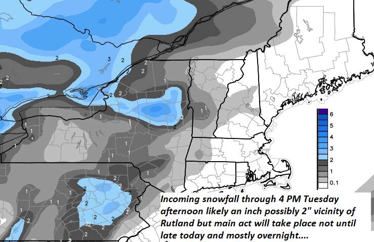
Winter Storm Warning 11 AM through 7 AM Wednesday morning Green Mountains east…Winter Weather Advisory elsewhere…
TODAY: Mainly cloudy. Rising chance for flurries and mountain snow showers. A high upper teens to mid 20s. Southeast winds 10 to 20 mph.
TONIGHT: Cloudy. Snow…moderate at times especially overnight with several inches of accumulation. A low around 15. Light west winds.
WEDNESDAY: Scattered flurries winding down in the morning. Intervals of afternoon sunshine with a leftover stray flurry or two. Blustery. A highin the upper teens. Southwest winds picking up 10 to 20 mph.
Looking further Ahead…
WEDNESDAY NIGHT: Mostly clear. A low ranging 5 to 20 below in the cold spots.
THURSDAY: Sunshine mixed with clouds but frigid. A high 5 to 10 above.
FRIDAY: Chance for a few flurries Northeast Kingdom early, otherwise lots of sunshine. A low zero to 10 below. A high around 10 above.
SATURDAY: Sunny with few high clouds later on. Frigid. A low 5 to 15 below. A high upper teens to mid 20s.
SUNDAY: Mainly cloudy. Rising chance for light accumulating snow showers. A low around 20. A high 25 to 30.
Average lows single digits. Average highs in the 20s.
RH/1-29-19[end]
