
Winter Storm Warnings N. C. VT and N E. Kingdom, spine the Green Mountains…Weather Advisories in effect elsewhere…into Thursday afternoon
TODAY: Gray. Wet snow…occasionally moderate to heavy at times this morning. Snowfall accumulations 3 to 8 inches most across elevated terrain and Green Mountains. Temperatures holding 32 to 35 degrees. West to northwest winds ramping up 10 to 25 mph with some blowing and drifting.
TONIGHT: Lots of clouds & blustery. Lingering mountain snow showers & valley flurries. Additional accumulation of dusting to 3 inches. A low upper teens to mid 20s. Northwest winds 10 to 20 mph.
THURSDAY: Considerable cloudiness. Accumulating snow or snow showers. A dusting to 2”. A high 20 to 25. Northwest winds 10 to 20 mph lowering wind chills.
Looking further Ahead…
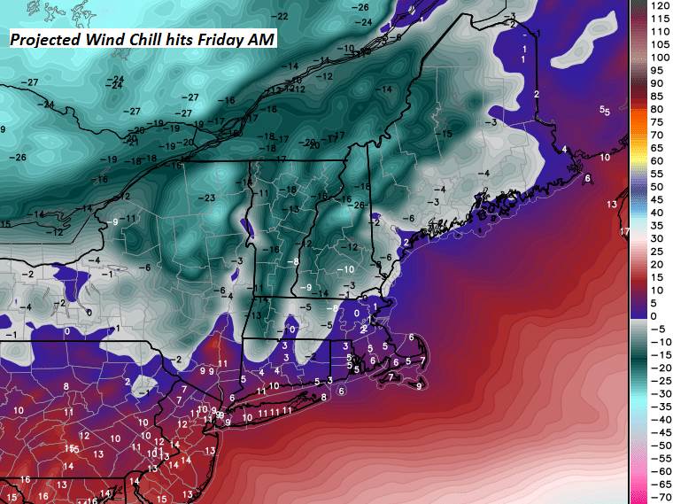
THURSDAY NIGHT: Mostly cloudy. Occasional “light snow showers or diamond dust flurries”. A dusting to an inch. Frigid. A low 5 below to 5 above
FRIDAY: Sunshine mixed with a few clouds. Frigid. “Diamond dust flurries”, A high in the single digits above zero.
SATURDAY: Arctic-like sunshine. A low 5 to 15 below. A high 5 to 10 above.
SUNDAY: Arctic-like sunshine. A low 10 to 25 below. A high zero to 10 above.
Average lows single digits. Average highs in the 20s.
RH/1-9-19[end]
