
Winter Weather Advisory into the afternoon…
TODAY: Overcast and gray. Light snow showers or flurries should exit mid to late morning. Little additional accumulation. Blustery at times. A high around 35. South winds 10 to 20 mph especially in the morning.
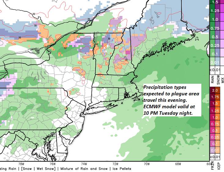
TONIGHT: A wintry mix of rain, freezing rain and sleet…transitioning to wet snow with poor travel. Sleet and snow accumulation dusting to 2” with pockets of minor glazing possible. A low in the low 30s. Light winds.
WEDNESDAY: Overcast & gray. Slushy wet snow likely with a dusting to 3”especially near the Green Mountains. A high near 35. West to northwest winds 10 to 25 mph and gusty.
Looking further Ahead…
WEDNESDAY NIGHT: Lots of clouds. Lingering mountain snow showers & valley flurries. Additional accumulation of dusting to 2 inches drier powder. A low in the teens.
THURSDAY: Mostly cloudy. Chance for accumulating snow showers, maybe a snow squall. Accumulation dusting to locally 4” drier powder with most in the northern Greens Mountains. A high in the low to mid 20s.
FRIDAY: Morning clouds mixing with more sunshine in the afternoon. Frigid. A low 5 below to 5 above. A high in the single digits.
SATURDAY: Arctic-like Sunshine. A low Zero to 10 below. A high 5 to 10 above.
Average lows single digits. Average highs in the 20s.
RH/1-8-19[end]
