
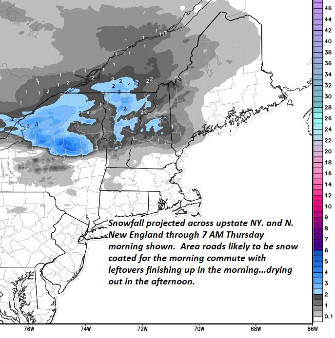
TONIGHT: Increasing clouds. Periods of light snow likely by late evening. Accumulation of about 1 to 2 inches. Temperatures holding upper teens to low 20s. Light southeast winds.
TOMORROW: Snow showers or flurries with up to an inch additional by mid day before exiting. Otherwise lots of clouds. A high 30 to 35. Northwest winds 10 mph.
THURSDAY NIGHT: Partly cloudy in the evening, then overcast. Chance for more flurries after midnight. A low around 25. Light southwest winds.
FRIDAY: Partly cloudy early, then lots of sunshine in the afternoon. A high in the upper 30s to near 40. Southwest winds 10 mph.
Looking further Ahead…
FRIDAY NIGHT: High cloudiness otherwise fair. A low 15 to 20.
SATURDAY: Mixed sun and clouds northern areas. Cloudy southern areas with a chance for rain or spotty mixed precipitation. A high in the mid 30s.
SUNDAY: Lots of clouds. Chance for leftover flurries southern areas. A low in the mid 20s. A high around 35.
MONDAY: Considerable cloudiness. A low in the single digits. A high mid teens to near 20.
TUESDAY: Cloudy. Chance for snow & possible mixed precipitation. A low in the teens. A high in the 20s.
Average lows mid single digits to around 15 above. Average highs mid 20s to near 30.
RH/1-2-19[end]
