
TODAY: Gray, but few breaks of sun away from the high terrain. A high 32 to 35. Light west winds.
TONIGHT: Gradual partial clearing. A low 20 to 25. Light west winds.
SATURDAY: “Pick of the weekend” Partly sunny then increasing clouds in the afternoon. A high in the low to mid 30s. Little wind.
Looking further ahead…
SATURDAY NIGHT: Overcast. Wet snow and sleet transitions to freezing rain and rain. Evening temperatures in the 20s…rising to freezing toward daybreak.
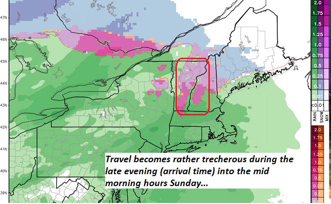
SUNDAY: Gray. Pockets of freezing rain with poor travel in the morning, Intermittent light rain or showers in the afternoon…tapering to scattered sprinkles. Areas of fog.Milder. A high pushing toward 40 late.
MONDAY: Lots of clouds. Good chance for rain showers mixing with wet snow flakes east of the Green Mountains. A low in the 30s. A high 40 to 45.
TUESDAY: Considerable cloudiness after morning flurries exit. Maybe some breaks of sun, but colder. A low upper teens to around 20. A high around 25.
WEDNESDAY: More sunshine than clouds but well below normal in temperature. A low 5 to 15 above. A high around 20.
THURSDAY: A mix of sun and clouds after a frigid start. A low 5 below to 5 above. A high in the 20s.
Average lows 20 to 25. Average highs upper 30s to low 40s.
RH/11-30-18[end]
