
-
- image00119
-
- image00217
-
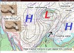
- image00317
-
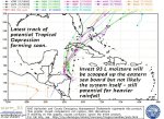
- image00413
-
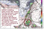
- image0056
-
- image006
-
- image007
TODAY: Becoming partly to mostly sunny & near normal in temperature. A high near 55. Light west winds.
TONIGHT: Clear but with considerable valley developing. A low in the upper 30s to low 40s. Light southeast winds.
SATURDAY: Morning fog burns of to lots of sunshine. High cloudiness in the afternoon. Pleasant. A high in the low 60s. South winds pick up 10 to 20 mph in the afternoon.
Looking further ahead…
SATURDAY NIGHT: Thickening clouds, leading to a slight chance for a shower western areas late. Mild with a low around 50.
SUNDAY: Cloudy and gray and becoming breezy with a showers likely. A high 55 to 60.
MONDAY: Overcast. Periods of rain likely…in the morning…moderate to heavy at times, tapering to showers in the afternoon.Blustery. Temperatures holding in the upper 40s to mid 50s.
TUESDAY: Clouds mixing with intervals of sun away from the mountains. Scattered rain showers mixed with wet snow flakes in elevated terrain. A low around 40. A high near 50.
WEDNESDAY: Partly sunny with thickening clouds late. A low near 32. A high around 50.
Average lows 30 to 35. Normal highs 50 to 55.
RH/10-27[end]
| Virus-free. www.avast.com |
