
-
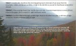
- image00110
-
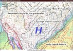
- image0028
-
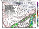
- image0038
-
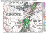
- image0047
TODAY: Considerable cloudiness this morning giving way to intervals of sun away from the mountains. Colder and blustery at times. A high in the mid 40s to around 50. Northwest winds 10 to 20 mph.
TONIGHT: A few evening clouds then mostly clear and cold. Freezing temperatures or areas of frost. A low in the upper 20s to around 32. Light northwest winds.
TUESDAY: Sunshine filtered through variable high clouds in the afternoon after a cold start. A high around 55. Southwest breeze 10 to 15 mph.
Looking further ahead…
TUESDAY NIGHT: Mostly clear. A low around 40.
WEDNESDAY: Lots of sunshine with a warming trend. A high in the mid 60s.
THURSDAY: Lots of sunshine becoming filtered through high clouds. A low around 45. A high in the mid 60s.
FRIDAY: A few clouds early then increasing sunny.A low in the 40s. A high in the upper 50sd to around 60.
SATURDAY: Sunshine mixed with variable high cloudiness.A low around 40. A high in the upper 60s to near 70.
SUNDAY: Partly to mostly sunny and well above normal in temperature. A low 45 to 50. A high in the low 70s.
Average lows low to mid 30s. Normal highs mid to upper 50s.
RH/10-16[end]
| Virus-free. www.avast.com |
