
-

- image0018
-

- image0026
-
- image0036
-
- image0045
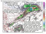
TODAY: Morning fog, then bright sunshine and blue skies. A high around 60. Little wind.
TONIGHT: Mostly clear. Patchy valley fog and widely scattered frost in the coldest hollows. A low 35 to 40. Light southeast winds.
FRIDAY: Morning fog, then mostly sunny. A high in the lower 60s. South breeze 10 to 20 mph.
Looking further ahead…
FRIDAY NIGHT: Fair early then, clouding up. Chance for a few showers or sprinkles overnight. A low in the upper 40s.
SATURDAY: Chance for few light showers or sprinkles exiting in the afternoon. Late day intervals of sun developing. A high mid to upper 60s.
SUNDAY: Lots of clouds northern areas with a chance for showers. Mixed clouds and sun after morning fog. Milder and breezy to windy at times. A low around 55. A high around 75. South to southwest winds 10 to 25 mph with higher gusts.
MONDAY: Morning showers exiting to partial afternoon sunshine. Rather cool and blustery with gusty . A low in the low 40s. A high only around 50.
TUESDAY: Morning low clouds and fog and good chance for frost,, then partly to mostly sunny. A low 30 to 35. A high in the low 50s.
Average low 35 to 40. Normal highs mid to upper 50s.
RH/10-12 [end]
| Virus-free. www.avast.com |
