
-

- image00117
-
- image00217
-
- image00318
-
- image00411
-
- image0052
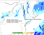
TODAY: Brief hints of sun, then thickening & lowering clouds. Showers arriving from south to north this afternoon. A high near 65. Southeast winds picking up 10 to 20 mph in the afternoon, much stronger along western slopes of the Green Mountains where gusts to exceed 40 mph.
TONIGHT: Cloudy. Intermittent light rain or showers. A low in the upper 40s. East winds 10 mph much stronger higher terrain with gust to 35 mph.
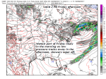
FRIDAY: Gray and chilly. Intermittent light rain in the morning, becoming showery and tapering off late. Clammy or raw with a high 50 to 55. Northeast winds 10 mph.
Looking further ahead…
FRIDAY NIGHT: Lots of clouds with eventual partial clearing overnight. A low 40 to 45.
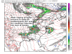
SATURDAY: Morning cloudiness gives way to periods of afternoon sunshine. A high upper 60s to low 70s.
SUNDAY: More clouds than sunshine. Slight chance for a sprinkle late with chance for rain Sunday Night. A low 45 to 50. A high in the upper 60s to low 70s.
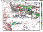
MONDAY MEMORIAL DAY: Cloudy. Chance for rain or showers, exiting in the afternoon to intervals of sun. A low 50 to 55. A high in the mid 50s to around 60.
TUESDAY: Partial morning sun then cloudy with a chance for showers and possible thunderstorms. A low 45 to 50. A high in the mid to upper 60s.
Average low in the upper 40s to around 50. Normal high in the upper 60s to low 70s.
RH/5-25[end]
| Virus-free. www.avast.com |
