
March 15th
-
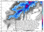
- image00112
-
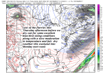
- image00211
-
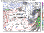
- image0039
Winter Storm Warning continues through 8 PM
TODAY: Occasional light accumulating snow or snow showers. Additional accumulations about ½ inch tow3ard eastern Vermont up to locally 3” near the Green Mountains. Total snow accumulation 14 to 26” A high 20 to 25 . Gusty northwest winds 10 to 20 mph producing some blowing and drifting and possible white-outs.
TONIGHT: Occasional light mountain snow showers or valley flurries. Additional dusting to an inch. Colder. A low 5 to 10. Northwest winds 10 to 15 mph with lowered wind chills..
THURSDAY: Mostly cloudy. Scattered flurries winding down. A high in the upper teens to low 20s.Gusty northwest winds 10 to 20 mph.
Looking Further ahead…
THURSDAY NIGHT: Becoming mostly clear and frigid. A low 5 below to 10 above.
FRIDAY: Pick of the week – a beauty with blue skies and bright sunshine. A high in the mid to upper 20s.
SATURDAY: Partly to mostly sunny. A low in the single digits. A high near 35.
SUNDAY: Clouds mixing with afternoon sunshine. A low in the single digits with a high in the mid 30s.
MONDAY: Lots of sunshine. A low in the single digits. A high in the mid to upper 30s.
TUESDAY: Sunshine mixing with clouds. Scattered light snow or rain showers. Maybe a sap run with a low in the teens and highs in the 40s.
Average lows in the mid to upper teens. Normal highs mid 30s to low 40s.
RH/3-15[end]
