
· Going on right now –
· 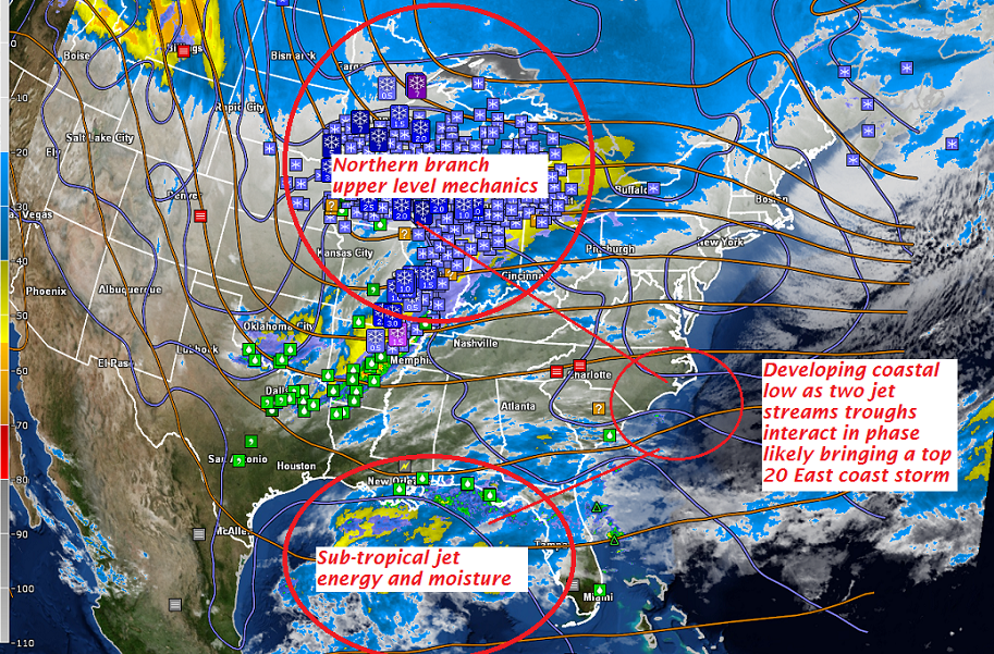
· Fully Mature Nor’easter likely at peak Tuesday 8 PM shown below by latest Europpean modeling…
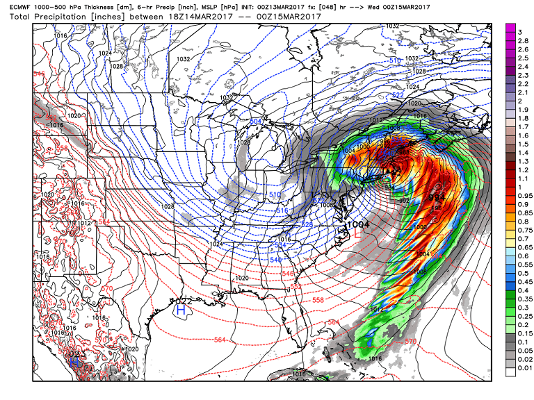
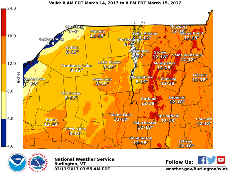
· NWS Burlington snowfall projection based on latest modeling through Sunday night shows decent snowfall and likely a tad conservative…
· European modeling snow totals at 15:1 snow to liquid water ratio’s which on average look about right due to cold air mass in place drawn into the storm for northern New England.
· More water equivlent toward the southern New england coast and especially Cape Cod.
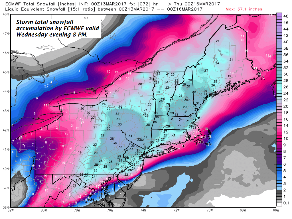
· Likely in the top 10 to 20 snow storms based off cold fluff factor and snowfall amounts due to southern stream moisture. Take out southern moisture supply likely more of a run of the mill Nor’easter closer to a foot, still impressive but this will top that easily.
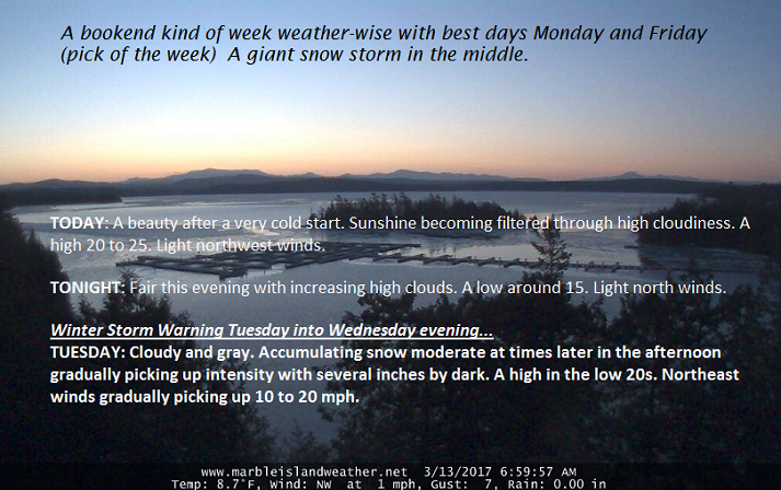
TODAY: A beauty after a very cold start. Sunshine becoming filtered through high cloudiness. A high 20 to 25. Light northwest winds.
TONIGHT: Fair this evening with increasing high clouds. A low around 15. Light north winds.
Winter Storm Warning Tuesday into Wednesday evening…
TUESDAY: Cloudy and gray. Accumulating snow moderate at times later in the afternoon gradually picking up intensity with several inches by dark. A high in the low 20s. Northeast winds gradually picking up 10 to 20 mph.
Looking further ahead…
TUESDAY NIGHT: Snow – moderate to heavy at times additional 6 to 12 inches likely. Temperatures in the teens. Some blowing and drifting possible.
WEDNESDAY: Accumulating snow…moderate at times early… becoming much lighter late morning on. Temperatures in the upper teens to mid 20s. Gusty northwest winds with considerable blowing and drifting and white-outs. Total accumulation 1 to 2 feet, with locally higher amounts in the mountains.
THURSDAY: Mostly cloudy. Periods of light accumulating snow near the mountains, otherwise scattered flurries. A low in the single digits, with a high 15 to 20. Gusty northwest winds with minor blowing and drifting.
FRIDAY: Pick of the week – blue skies and bright sunshine. A low in the single digits with a high 25 to 30.
Average lows in the teens. Normal highs mid 30s to low 40s.
RH/3-13[end]

Yu the man!! I am 68 years old and live in n.y.c. AND YOU ARE THE MOST COMPREHENSIVE AND ARTICULATE METEREOLOGIST I HAVE EVER HEARD! I follow you on wdev streaming live. Worried that sleet may mix in down here! NAM 12 z is showing mix. GFS is slow today showing yesterday’s run!! as I write this. Waiting with bated breath for Euro. 12z. Unusual for storm to have both Vermont and N.Y.C. to have similar amounts of snow forecasted! I agree with that manmade global warming is an ingredient for crazy weather. Our ocean water temps. are about 5 degrees warmer every winter than they used to be. Hoping for blockbuster.
LikeLike