
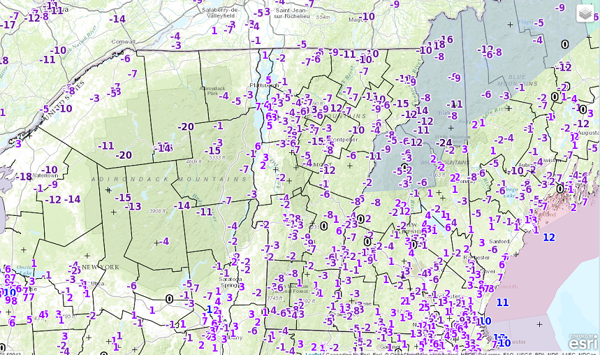
· Coldest morning we might see in the next two weeks occurring this morning as arctic air will moderate and milder air will quickly blow in for nasty wintry mixed precip late Tuesday into Tuesday night.
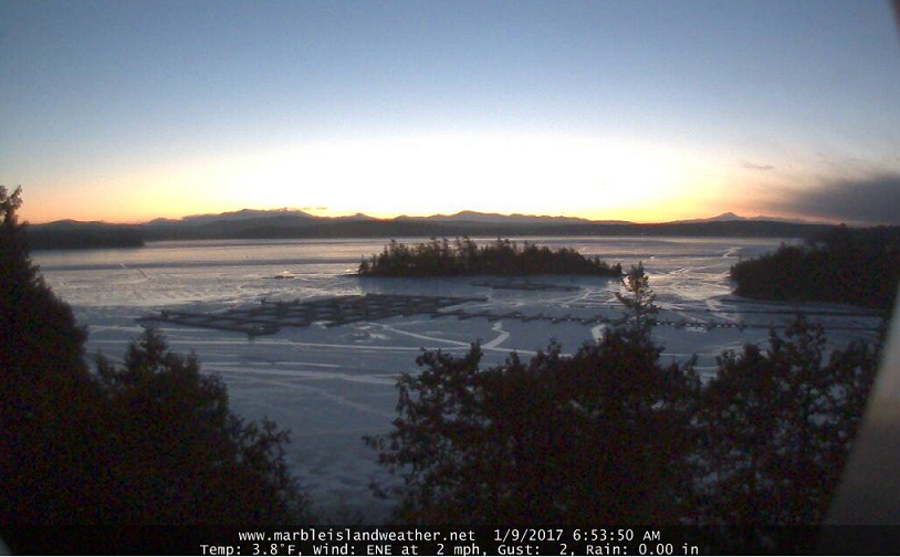
· Below courtesy of Marble Island Weather looking east and southeast across Mallets Bay at Mount Mansfield and off to the right Camels Hump – note cirrus clouds (far right) which will be on the increase today filtering the sunshine.
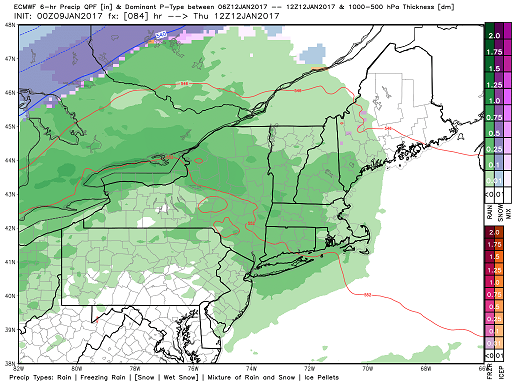
· Below is looking at Rain Storm #2 that moves in late Wednesday night into Thursday.
· We should see net increase in snow and sleet for Tuesday evening…then erased Wednesday 40s plus rainfall, and second system Wednesday-Thursday for all rain and highs that might push into upper 40s to near 50 Thursday.
· This to be followed by sharply colder weather but not as cold as what we are experiencing currently this morning.
TODAY: More sunshine than clouds. Cold with a high around 15.Light south winds.
TONIGHT:Mostly clear this evening then increasing high clouds. A low zero to 10 above. South winds 10 mph across the hills.
TUESDAY: Periods of morning sunshine, then cloudy. Periods of wet snow developing late in the day making for slick travel with up to a slushy inch. A late day high 30 to 35. Increasing south winds 10 to 25 mph in the afternoon.
Looking Further ahead…
TUESDAY NIGHT: A wintry mix of wet snow and sleet…changing to freezing rain and rain…exiting toward day break. A period of hazardous travel likely with snow and sleet accumulation 1 to locally 3 inches. Temperatures rising through the 30s. Gusty south winds.
WEDNESDAY: Becoming partly sunny and milder. A high around 45.
THURSDAY: Mainly cloudy. Periods of light rain. Areas of fog. A low in the mid 30s. A high 45 to 50.
FRIDAY: Chance for a leftover flurry or mountain snow shower, otherwise partly cloudy. A low in the mid 20s. A high in the low 30s.
Average lows in the single digits. Normal highs mid to upper 20s.
RH/1-9-17[end]

Roger: don’t have your e-mail address. Mine is dmm@jcomail.com.
Send me a message, I have an old photo of you up to tele-camp in the NE kingdom I would like to send you, and would like to invite you to my snow party January 28th.
Don (aka Tele-rock)
Kingdom Tele-Boys
LikeLike
rogerweather@myfairpoint.net will work. Unfortunately going to out of the region attending a conference then its possible the following day if its in the afternoon. you ought to wait a couple weeks later thinking big snow bu then!
LikeLike