
Whew! Quiet weather now on the way or at least not as unsafe. Watch the sides or shoulders of the roads where there is ice or melting ice.
Your walkways are icy and later tonight when temps go below 32 degrees a dusting to an inch of fluffy snowfall will not adhere to the ice below – use caution as hidden ice with the wrong “footwork” can be injurious.
Best break comes in Wednesday afternoon-night and into the first part of Thursday before snow moves in Thursday afternoon
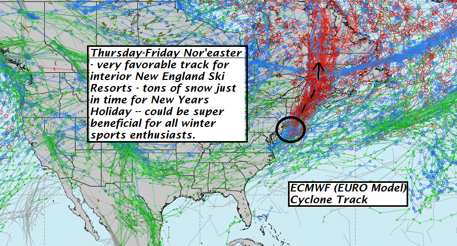
Upcoming compact – potent Nor’easter — arrives Thursday unloads especially Thursday night into first half of Friday…finishes off with an up-slope component for western slopes of central and northern Greens likely some areas better than one foot! And just in time for New Year’s celebration!!!
Ski areas should be Rockin – fingers crossed this puppy holds true and I think it will several model runs now.
TODAY: Intervals of sun mixed with clouds. Isolated northern mountain flurries. Blustery and gradually colder. An early high 40 to 45 with temperatures through the 30s. West winds 10 to 20 mph.
TONIGHT: Mostly cloudy. Occasional flurries or light snow showers with a dusting to an inch of accumulation. A low 20 to 25. Light west winds.
WEDNESDAY: More clouds than sun. Occasional morning flurries with some light accumulation drying up in the afternoon. A high in the upper 20s. Northwest winds 10 mph.
Looking Further ahead…
WEDNESDAY NIGHT: Mostly cloudy. A low in the upper teens.
THURSDAY: Clouding up. Accumulating snow likely especially in the afternoon. A high in the upper 20s.
THURSDAY NIGHT: Overcast and becoming blustery.Accumulating snow…moderate to heavy at times with several or more inches possible. Temperatures in the mid 20s.
FRIDAY: Overcast and blustery. Good chance for accumulating snow…becoming lighter in the afternoon with a few breaks of sun late.Temperatures holding in the mid 20s.
SATURDAY: Considerable clouds. Chance for light accumulating snow developing. A low 5 to 10. A high in the mid 20s.
SUNDAY: More clouds than sun. Chance for a flurry early.A low in the mid 20s. A high around 35.
Average lows upper single digits to low teens. Normal highs upper 20s to around 30.
RH/12-27[end]
