Updated Wednesday Evening Forecast — January 10th, 2024

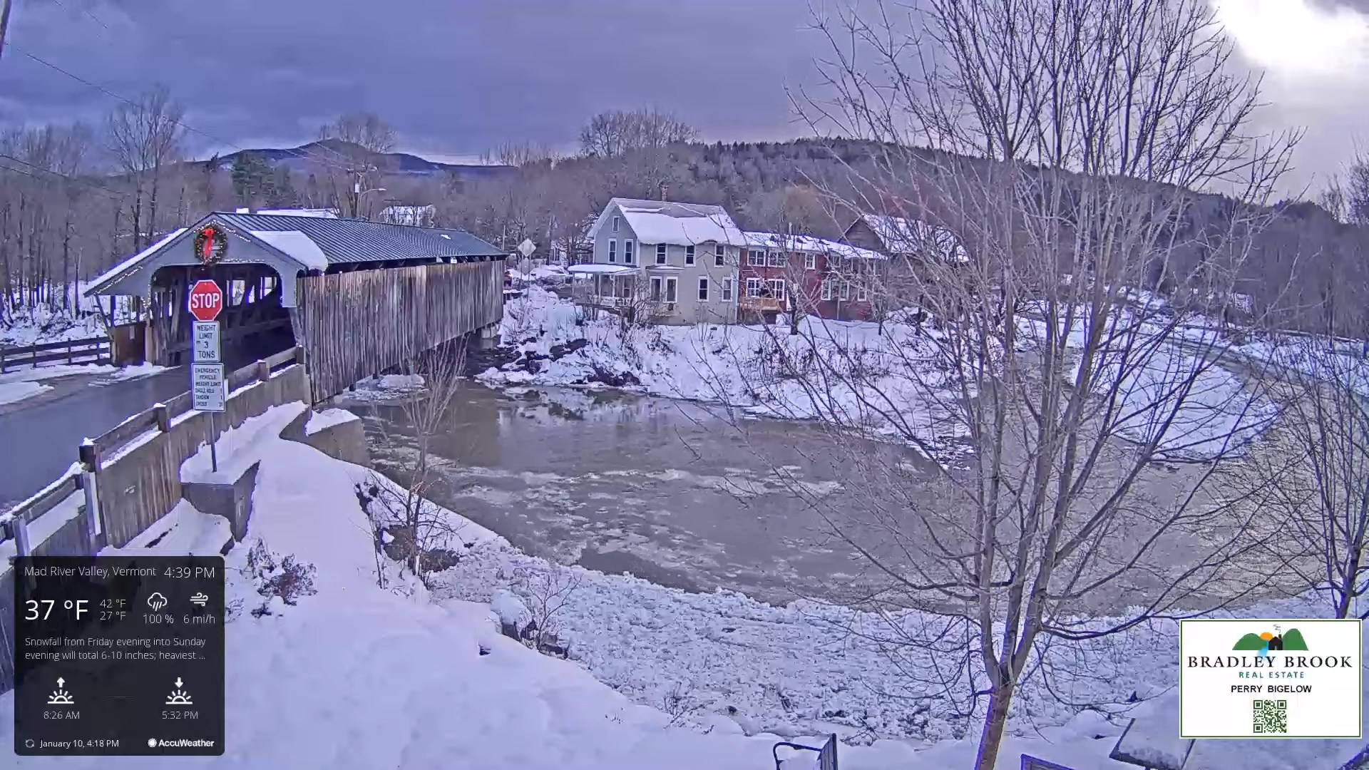
TONIGHT: Mostly cloudy. A few stray mountain flurries. A low 20 to 25. West to southwest winds 10 to 15 mph.

TOMORROW: Considerable cloudiness. Scattered flurries developing later in the afternoon, a dusting to around an inch elevated terrain. A high about 32. West winds 10 mph.

THURSDAY NIGHT: Considerable cloudiness. A low upper teens to around 20. Light west winds.

FRIDAY: Pick of the week.A beauty. Lots of sunshine with a few high cloud later in the afternoon. A high in the upper 20s to around 30. Light variable winds

Looking further ahead

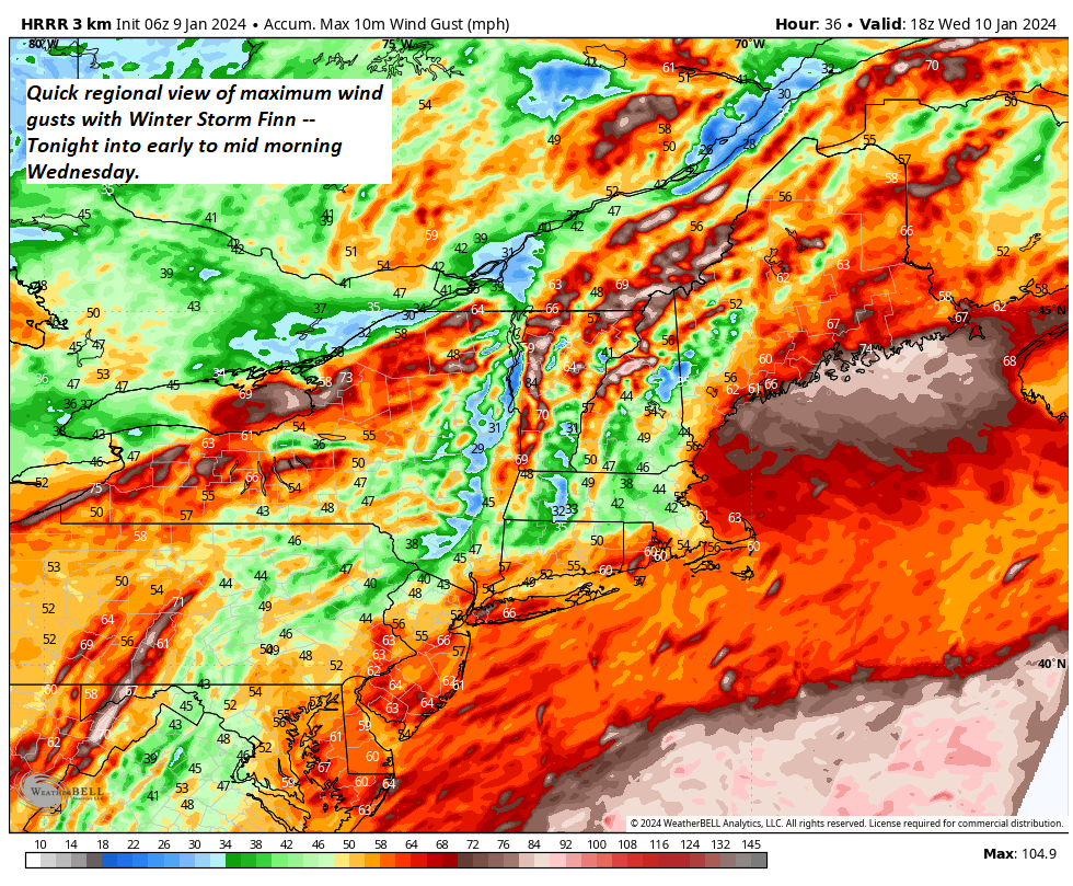
FRIDAY NIGHT: Thickening clouds, leading to a rising chance for wet snow briefly moderate to heavy before changing over to mixed precipitation with slippery travel. Increasingly windy, & turning milder. An evening low   15 to 20. Southeast winds picking up 15 to 30 mph with gusts exceeding 45 mph western slopes of the Green Mountains.

SATURDAY: Morning clouds, breezy to windy, & turning milder. A wintry mix with poor travel transitioning to periods of rain showers before exiting as sprinkles. Partial afternoon sunshine. A high around 40.

SUNDAY: Mostly cloudy. Chance for scattered light accumulating snow showers or flurries. A low in the upper teens. A high near 25.

MONDAY: Mixed sun and clouds. A low 10 to 15. A high in the lower 20s.

Average lows single digits. Average highs mid-20s to 30

RH/1-10forecast][end]

Updated Tuesday Evening Forecast — January 9th, 2024

High Wind Warnings & Advisories, plus Winter Weather Advisories thru Wednesday Morning.

TONIGHT: Windy & overcast. A burst of heavy wet snow this evening…with 3” to locally 8” of accumulation (most in the Green Mountains)…transitions to rain overnight with treacherous travel. Temperatures rise 35 to 40 overnight. Southeasterly winds 15 to 35 mph with gusts 45 to 75 mph, strongest higher terrain and western slopes.

TOMORROW: Rain…tapering to scattered light showers in the morning, isolated sprinkles in the afternoon. Milder. A few intervals of late-day sun. A high 40 to 45. Southwest winds 10 to 15 mph.

WEDNESDAY NIGHT: Mostly cloudy. Widely scattered flurries. A low in the mid to upper 20s. West to southwest winds 10 mph.

THURSDAY: Mainly cloudy. A stray flurry early…becoming more numerous in northern areas with a minor coating in the mountains. A high 30 to 32. West winds 10 mph.

Looking further ahead

THURSDAY NIGHT: Considerable cloudiness. A low 15 to 20.

FRIDAY: Pick of the week. Lots of sunshine with some high cloudiness. The high mid-20s to around 30.

SATURDAY: Morning clouds, breezy to windy, & turning milder. Chance for accumulating wet snow with a few inches possible… transitioning to periods of rain or showers. Intervals of afternoon sunshine. A low 15 to 20. A high 40 to 45.

SUNDAY: Mostly cloudy. Chance for scattered accumulating snow showers or flurries. A low mid-teens to around 20. A high upper 20s to around 30.

Average lows single digits. Average highs mid-20s to 30

RH/1-9forecast][end]

Updated Monday Evening Forecast — January 8th, 2023

TONIGHT: Partly cloudy this evening, then clouding up. A low around 15. Little wind.

High Wind Watch from Tuesday afternoon thru Wednesday afternoon…

TOMORROW: Gray. Light accumulating snow develops around or before dark. A high in the upper 20s to near 30. Southeast winds develop at 10 to 20 mph later in the afternoon.

TUESDAY NIGHT: Overcast & windy. Wet snow is likely, moderate to heavy at times …with a few to several inches of accumulation…transitions to a wintry mix…and eventually rain by daybreak. Temperatures rise into the mid and upper 30s by daybreak. Southeasterly winds 15 to 35 mph with gusts over 45 mph.

WEDNESDAY: Rain…tapering to scattered light showers later morning on. Milder with intervals of sunshine breaking out. A high in the low to mid-40s. Southwest winds 10 to 15 mph.

Looking further ahead

WEDNESDAY NIGHT: Mostly cloudy. Widely scattered flurries. A low around 30.

THURSDAY: Mainly cloudy. A stray flurry becoming more numerous in northern areas. A high in the low to mid-30s.

FRIDAY: Pick of the week.Partly to mostly sunny. A low around 25. A high near 32.

SATURDAY: Morning clouds. Chance for accumulating wet snow with a few inches possible transitioning to periods of rain or showers with intervals of sunshine. A low in the mid-20s. A high around 40.

Average lows single digits. Average highs mid-20s to 30

RH/1-8forecast][end]

Updated Friday Evening Forecast — January 5th, 2024

TONIGHT: Mostly cloudy.Scattered flurries with a minor coating central and northern areas. A low near 20. Light west to northwest winds.

TOMORROW: Maybe an early hint of sun, otherwise lots of clouds. A high mid to upper 20s. Light east to southeast winds.

Winter Storm Watch Rutland and Windsor counties on south…

SATURDAY NIGHT: Overcast. A rising chance for light snow or flurries. A low ranging around 20. Easterly winds 10 mph.

SUNDAY: Gray. Accumulating snow…moderate at times especially central and southern areas…winding down early evening. Accumulations of 1 to 4” far northern tier, 3 to 7” Barre-Montpelier, and 6 inches to locally a foot” across southern Green Mountains. A high in the low to mid-20s. Light northeast winds.

Looking further ahead

SUNDAY NIGHT: Lots of clouds. A few leftover flurries near the mountains especially in the evening.Lows upper teens to around 20

MONDAY: Mostly cloudy north, partly sunny central and south. A high 25 to 30.

TUESDAY: Brief hints of morning sun, then thickening clouds. Slight chance for light accumulating snow toward dark. A low 10 to 15. A high near 30.

TUESDAY NIGHT – WEDNESDAY: Periods of wet accumulating snow…moderate to heavy at times transitions to mixed precipitation, then wind-blown rain, becoming lighter & showery in the afternoon. Breezy to windy with gusts exceeding 40 mph from the southeast. Temperatures near freezing Tuesday evening, rising into the 40s Wednesday afternoon. 

Average lows single digits to around 10 above. Average highs mid-20s to around 30

RH/1-5forecast][end]

Updated Thursday Evening Forecast — January 4th, 2024

TONIGHT: Some mountain clouds but generally mostly clear. A few high clouds overnight.A low mid-single digits to around 10 above. Light northwest winds.

TOMORROW: Sunshine with more clouds northern areas in the afternoon. Maybe a stray flurry Canadian border. A high about 25. West winds 10 mph.

FRIDAY NIGHT: Variable clouds.A stray northern border flurry.A low 15 to 20. Light west winds.

SATURDAY: Hints of early sun, then cloudy. A high mid-20s to near 30. Light southeast winds.

Looking further ahead

SATURDAY NIGHT: Overcast. A rising chance for light snow overnight. A low in the upper teens.

SUNDAY: Gray. Accumulating snow likely…moderate at times southern areas…exiting late. A few to several inches possible southern areas, lesser amounts north. A high around 25.

MONDAY: Mixed sun and clouds. Lows in the mid-teens. A high 25 to 30.

TUESDAY: Brief hints of sun, then cloudy. Slight chance for light accumulating snow toward dark. A low upper single digits to around 15 above. A high near 30.

Average lows single digits to around 10 above. Average highs mid-20s to around 30

RH/1-3forecast][end]

Updated Wednesday Evening Forecast — January 3rd, 2023

TONIGHT: Lots of clouds. A rising chance for flurries in far northern areas later overnight. A low in the mid-20s. Light south to southwest winds.

TOMORROW: Scattered light accumulating snow showers…a dusting to an inch in the morning. Skies becoming partly to mostly sunny and turning blustery. A high around 30. Light southwest winds shifting to northwesterly 10 to 15 mph late morning on.

THURSDAY NIGHT: Mostly clear with a few high clouds.A low around 10 above. Light northwest winds.

FRIDAY: Sunshine with a few more clouds later in the afternoon. Maybe a stray flurry Canadian border. A high of about 25. West winds 10 mph.

Looking further ahead

FRIDAY NIGHT: Variable mainly high cloudiness.A stray northern border flurry.A low mid to upper teens.

SATURDAY: Sunshine filtered through high cloudiness, then cloudy in the afternoon. A high mid to upper 20s.

SUNDAY: Gray. Good chance for accumulating snow or snow showers, possibly moderate at times south of the Barre-Montpelier area with a few inches of accumulation. A low in the upper teens. A high in the mid-20s.

MONDAY: Mostly cloudy. Lows in the mid-teens. A high near 30.

Average lows are single digits to around 10. Average highs mid-20s to around 30

RH/1-3forecast][end]

Updated Tuesday Morning Forecast — January 2nd, 2024

TODAY: A few high clouds, otherwise lots of sunshine. A high of about 35. Light southwest winds.

TONIGHT: Fair with some high cloudiness, giving way to more clouds in northern areas overnight with a stray flurry or two. A low 20 to 25. Light southwest winds.

WEDNESDAY: Considerable cloudiness. Widely scattered flurries. A high around 35. Light southwest winds.

Looking further ahead

WEDNESDAY NIGHT: Lots of clouds. Scattered flurries in northern areas with a dusting. A low around 25.

THURSDAY: Gray skies. Chance for light accumulating snow showers…a dusting to an inch or two, exiting late to partial clearing. A high near 30.  

FRIDAY: Morning sunshine then more clouds in northern areas. Chance for accumulating light snow showers in northern areas after dark. A low around 10. A high around 25.

SATURDAY: Sunshine filtered through high cloudiness, thickening up later on. A low 10 to 15. A high around 25.

SUNDAY: Thickening clouds, leading to the chance for snow or snow showers. A low in the mid to upper teens. A high in the mid-20s.

Average lows are single digits to around 10 above. Average highs mid-20s to around 30

RH/1-1forecast][end]

Updated Monday Morning Forecast — January 1st, 2023

TODAY: Morning clouds with widely scattered flurries toward the Champlain Valley. Gradual clearing with increasing amounts of sunshine later this afternoon. A high in the mid-20s. Light northwest winds.

TONIGHT: Mostly clear. A low in the mid-teens. Little wind.

TUESDAY: A few high clouds, otherwise lots of sunshine. A high around 32. Light southwest winds.

Looking further ahead

TUESDAY NIGHT: Increasing clouds. A low 20 to 25. Widely scattered flurries in northern areas late.

WEDNESDAY: Considerable cloudiness. Scattered flurries. A high in the mid-30s.

THURSDAY: Gray skies with a few mountain flurries early, giving way to intervals of afternoon sun. A low around 25. A high in the low to mid-30s.

FRIDAY: Morning sunshine then partly sunny with more clouds in northern areas. Chance for accumulating light snow showers late. A low in the single digits above zero. A high around 25.

SATURDAY: Variable high cloudiness otherwise lot of sunshine. A low in the single digits. A high low to mid-20s.

Average lows are single digits to around 10 above. Average highs mid-20s to around 30

RH/12-29forecast][end]

Updated Friday Evening Forecast — December 29th, 2023

TONIGHT: Cloudy.Light rain showers transitioning to wet snow this evening, northwest to southeast. A slushy dusting valleys to near 2” higher elevations and slippery. A low 30 to 32. Light west winds.

TOMORROW: Gray and a little blustery at times. A few wet snow showers or flurries mainly in the mountains. Little temperature change with a high near 35. Northwest winds 10 mph.

SATURDAY NIGHT: Mostly cloudy.Widely scattered flurries. A low 20 to 25. Northwest winds 10 mph.

SUNDAY: Morning clouds with a stray flurry, partial afternoon sunshine. A high upper 20s. Northwest winds 10 mph.

Looking further ahead

SUNDAY NIGHT NEW YEARS EVE: Variable cloudiness. A morning low upper teens to around 20.

MONDAY NEW YEARS DAY: Morning clouds. Slight chance for a mountain flurry, then partial afternoon sunshine. A high mid to upper 20s.

TUESDAY: Partly to mostly sunny. A low 20 to 25. A high around 32.

WEDNESDAY: Lots of mid and high clouds. A low around 20. A high in the mid-30s.

Average lows mid-single digits to lower-teens. Average highs mid-20s to lower 30s.

RH/12-29forecast][end]

Updated Wednesday Evening Forecast — December 27th, 2023

TONIGHT: Overcast. Occasional light rain & drizzle with areas of fog. A low 35 to 40. Light east winds.

TOMORROW: Light rain…central and southern areas then spreading north in the afternoon. Otherwise cloudy. A high 40 to 45. Light northeast winds.

THURSDAY NIGHT: Cloudy. Occasional light rain or showers are likely. A low around 35. Light northeast winds.

FRIDAY: Gray skies. Scattered rain showers eventually mixed with wet snowflakes mountain summits. The high upper 30s to around 40. Light variable winds.

Looking further ahead

FRIDAY NIGHT: Cloudy. Scattered light accumulating snow showers or flurries with a minor coating overnight. A low upper 20s.

SATURDAY: Gray and a little blustery at times. Scattered wet snow showers with minor coating in the higher terrain. A high 32 to 35 degrees.

SUNDAY: Maybe some breaks of sun, otherwise a few leftover mountain flurries. A low in the low to mid 20s. A high around 32.

MONDAY NEW YEARS DAY: Morning clouds then partial afternoon sunshine. Slight chance for a mountain flurry. A low 20 to 25. A high upper 20s to near 30.

Average lows are mid-single digits to lower teens. Average highs are mid-20s to lower 30s.

RH/12-27forecast][end]