Thursday Night Weather — 12-12-24

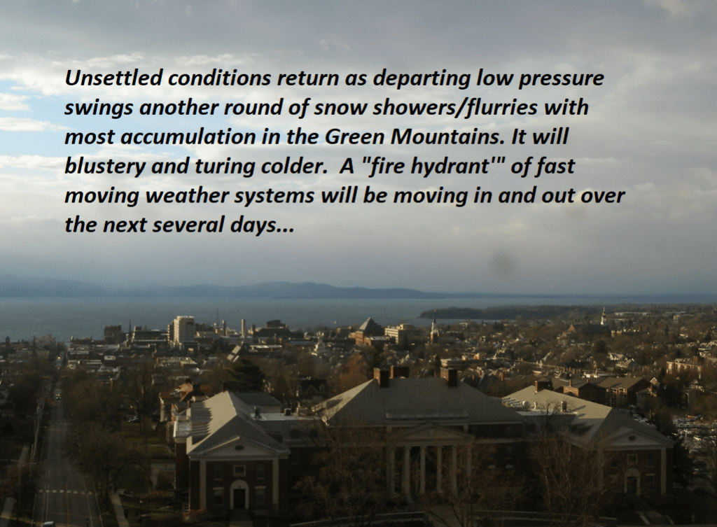
Roger Hill’s Radio Vermont forecast 3:00 PM Thursday 12-12-24

TONIGHT: Scattered northern flurries with little accumulation,otherwise partially moonlit and colder. A low 10 to 15 above. West to southwest winds 10 to 15 mph becoming light overnight.

TOMORROW: More sun than clouds & continued cold. A stray flurry far northern areas. A high in the mid-20s. Westerly winds 10 to 15 mph in the afternoon.

FRIDAY NIGHT: Mostly clear with a few more clouds overnight. A low ranging 5 to 15 above. Light west to northwest winds.

SATURDAY: A few morning clouds otherwise lots of sunshine. Rather chilly. A high near 25. Light northwest winds.

Looking further ahead

Full Cold Moon 4:02 AM

SATURDAY NIGHT: Clear & moonlit skies. A low in the single digits.

SUNDAY: Sunshine becoming filtered through high clouds. A high upper 20s.

MONDAY: Sunshine with high cloudiness. Seasonal temperatures. A low 15 to 20. A high near 35.

TUESDAY: Gray. Chance for rain with spotty mixed precipitation early. An early low around 32. A high 40 to 45.

Average lows teens to near 20. Average high upper 20s to mid-30s

RH/12-12forecast][end]

Thursday Night Weather

Roger Hill’s Radio Vermont forecast 3:00 PM Thursday 12-5-24

TONIGHT: Lots of clouds & blustery. Accumulating snow showers near the Green Mountains with lighter snowfalls or flurries elsewhere winding down overnight. Accumulations of a dusting…to locally 3” northern Green Mountain Ski Resorts. A low-upper teens. Northwest winds 10 to 20 mph and gusty.

TOMORROW: Morning clouds giving way to intervals of sunshine. Blustery and cold. A high in the upper teens to low 20s. Northwest winds 10 to 20 mph.

FRIDAY NIGHT: Considerable cloudiness. Scattered light lake effect snow showers or flurries after midnight. Minor accumulation. An early evening low around 15. Light southwest winds.

SATURDAY: Mainly cloudy & rather cold. Scattered flurries early then drying up. Little accumulation. A high in the low 20s. Light west winds.

Looking further ahead

SATURDAY NIGHT: Cloudy. Good chance for snow showers developing overnight, with accumulations around an inch. A low 5 to 10 above.

SUNDAY: Gray. Chance for light snow showers…dusting to an inch northern areas. A high near 40

MONDAY: Increasing clouds. Chance for rain or mixed precipitation developing in the afternoon. A low around 30. A high around 40.

TUESDAY: Cloudy. Chance for rain or mixed precipitation…possibly significant amounts with slick travel. A low around 32. A high low to mid 40s.

Average low mid-teens to low 20s. Average high 35 to 40

*This forecast and to be issued – Monday thru Friday.

RH/12-5forecast][end]

Roger Hill’s Radio Vermont forecast 3:00 PM Wednesday 12-4-24

Winter Weather Advisory thru late Thursday night…for multiple rounds of accumulating snow & slippery travel…

TONIGHT: Overcast. Occasional light accumulating snow or snow showers. Accumulations of an inch or two”. A low around 25. South winds 10 mph but gustier Champlain Valley. 

TOMORROW: Gray & becoming blustery late. Occasional light accumulating snow or snow showers continues. Accumulation about dusting to 2”…most off the valley floors. A high 32 to 35. Light south winds shifting to westerly and increasing late.

THURSDAY NIGHT: Lots of clouds & blustery. Light accumulating snow or snow showers with additional accumulation of 1 to locally 3”…most western slopes of the Greens. A low 10 to 15. Northwest winds 10 to 20 mph and gusty.

FRIDAY: Morning clouds giving way to intervals of sunshine. Blustery and colder with temperatures in the teens. Northwest winds 10 to 20 mph.

Looking further ahead

FRIDAY NIGHT: Considerable cloudiness. Scattered light lake effect snow showers or flurries after midnight with minor accumulation. A low 5 to 15 above.

SATURDAY: Mainly cloudy & rather cold. Chance for accumulating “lake effect” snow showers.. A high low to mid 20s.

SUNDAY: Gray. Chance for morning snow showers or flurries exiting in the afternoon. A low in the 20s. A high near 40

MONDAY: Increasing clouds. Chance for rain developing in the afternoon. A low in the 30s, highs in the lower 40s.

Average low mid-teens to low 20s. Average high 35 to 40

*This forecast and to be issued – Monday thru Friday.

RH/12-4forecast][end]

Tuesday night Forecast —

Roger Hill’s Radio Vermont forecast was updated 4 PM Tuesday 12-3-24

TONIGHT: Occasional flurries and mountain snow showers with a dusting to an inch ending toward midnight. Otherwise becoming partly to mostly cloudy. Light west winds. 

Winter Weather Advisory Wednesday Afternoon lasting into late Thursday night…multiple rounds of snow…

TOMORROW: A few breaks of morning sun, then clouding up. A rising chance for light accumulating snow or snow showers. The high upper 20s about 30. Winds becoming southerly 10 mph higher near Lake Champlain.

WEDNESDAY NIGHT: Overcast. Occasional light accumulating snow with an inch or two. A low near 25. Blustery out of the south.

THURSDAY: Gray skies with a peek or two of dim sun. Occasional accumulating light wet snow with about 1 to 2 inches especially higher northern terrain. A high 32 to 35. South winds 10 to 15 mph. 

Looking further ahead

THURSDAY NIGHT: Cloudy. Light snow accumulation up to 2” likely. A low around 15.

FRIDAY: More sun than clouds. Colder & blustery. A high 20 to 25.

SATURDAY: Mainly cloudy & rather cold. Chance for accumulating “lake effect” snow showers. Frigid with a morning low near 5 above. A high mid-20s.

Average low mid-teens to low 20s. Average high 35 to 40

*This forecast and to be issued – Monday thru Friday.

RH/12-3forecast][end]

December 2nd forecast details

Roger Hill’s Radio Vermont forecast 2:30 PM Monday 12-2-24

THIS AFTERNOON: Clouds with a few intervals of sun away from the mountains. Widely scattered mountain flurries. A high near 30.

TONIGHT: Variable clouds. Scattered snow showers and flurries especially northwestern Vermont with a dusting to a couple fluffy inches western slopes of the Greens. A low mid-teens to near 20. Light northwest winds.

TOMORROW: Mainly gray. Chance for snow showers/flurries mainly Champlain Valley. A high upper 20s to around 30. Light west winds.

Looking further ahead

TUESDAY NIGHT: Partly cloudy. A low around 15.

WEDNESDAY: A few breaks of morning sun, then clouding up leading to a rising chance for light accumulating snow or snow showers.A high upper 20s about 30.

THURSDAY: Gray skies with a peek or two of dim sun. Occasional accumulating light wet snow showers. A low near 25. A high 32 to 35 & breezy out of south.  

FRIDAY: Northern cloudiness with intervals of sun away from the mountains otherwise. Colder & blustery. Temperatures around 20, falling into the teens.

THIS WEEKEND: Unsettled and cold. Chance for accumulating snow showers especially Saturday. Lows in the teens, with highs in the 20s.   

Average low mid-teens to low 20s. Average high 35 to 40

*This forecast and to be issued – Monday thru Friday.

RH/12-2forecast][end]

Big warming push next 24 hours comes with border skirmishes of sprinkles light rain shower activity. Overall this more unsettled than last week, not as warm, no huge wash-outs and on the dry side.

Roger Hill’s Weathering Heights Forecast 10:45 AM Monday November 4th, 2024

THIS AFTERNOON: Considerable cloudiness. A high around 45. Southeast winds 10 mph.

TONIGHT: Overcast. Widely scattered rain showers northern areas. A low in the low 40s. Light south winds stronger near Lake Champlain.

TOMORROW: Morning clouds with a chance for rain showers. Partial afternoon sunshine. A high near 65. South winds 10 to 15 mph, stronger near Lake Champlain.

Looking further ahead

TUESDAY NIGHT: Fair with some high cloudiness. A low in the in the upper 50s.

WEDNESDAY: Gray.Good chance of rain showers. Late day breaks of sun. A high mid to upper 60s.

THURSDAY: Morning clouds with leftover rain showers exiting. Increasing afternoon sunshine.A low near 40. A high 50 to 55.

FRIDAY: Morning sun then thickening clouds leading to a few showers north.A low around 35. A high around 50.

Average low mid-20s to low 30s. Average high mid-40s to low 50s

Full out stick season

This forecast and weather brief will be done every other day – Monday, Wednesday & Fridays until further notice.

RH/11-4forecast][end]

Blustery, drier and colder but still lingering clouds and sprinkles. Decent weather, though chilly, this weekend into Monday, warmer & dry Election Day.

Roger Hill’s Weathering Heights Forecast 10:45 AM Friday, November 1st, 2024

THIS AFTERNOON: Mixed sun and clouds & colder, maybe a mountain sprinkle. Blustery to windy. Temperatures falling through the 50s. West winds 10 to 25 mph shifting to northwesterly.

TONIGHT: Cloudy periods. A low 32 to 35. Northwesterly winds becoming light.

TOMORROW: Lots of clouds, with intervals of sun away from the mountains. Slightly below normal in temperature. A high low to mid-40s. Northwest winds 10 mph.

Looking further ahead

SATURDAY NIGHT: Becoming clear and cold with a hard freeze. A low mid to upper 20s.

SUNDAY: Bright sunshine gives way to variable high cloudiness. A high around 45.

MONDAY: Clouding up. Chance for rain showers. A high low to mid-40s.

TUESDAY Election Day: Morning clouds then lots of sunshine. Much milder with a high in the low to mid 60s.

Average low upper 20s to low 30s. Average high mid-40s to low 50s

Full-out stick season

This forecast and weather brief will be done every other day – Monday, Wednesday & Fridays until further notice.

RH/11-1forecast][end]

Updated Monday Morning Forecast — January 22nd, 2024

Coldest climatological period of winter…

TODAY: Periods of morning sunshine give way to more cloudiness this afternoon. A high jumps up into the low 30s. Light southwest winds, stronger near Lake Champlain.

TONIGHT: Gray skies. Flurries likely later this evening with a minor coating. A low in the mid-20s. Southwest winds 10 mph shifting to westerly overnight.

TUESDAY: Scattered flurries in the morning drying up in the afternoon. A high around 30. Light northwest winds.

Looking further ahead

TUESDAY NIGHT: Overcast. A rising chance for light snow developing south to north toward midnight with light accumulations. A low in the upper teens to low 20s.

WEDNESDAY: Chance for light snow or snow showers in the morning. Around an inch of accumulation.A high upper 20s to around 30.

THURSDAY: Overcast.Chance for rain, becoming moderate at times, beginning early as a wintry mix with icy travel possible.An early low around 30. A high reaching into the upper 30s.

FRIDAY: Cloudy.Chance for rain showers in the morning isolated in the afternoon.Areas of fog. A low in the low to mid 30s. A high pushing to near 50.

Average lows single digits. Average highs mid to upper 20s coldest period of winter.

RH/1-22forecast][end]

Updated Friday Evening Forecast — January 12th, 2024

High Wind Warnings & Wind Advisories 11 PM tonight thru 11 AM Saturday…worst western slopes, portions of the northern tier. Winter Weather Advisory Orange County south.

TONIGHT: Thickening clouds, leading to wet snow & a wintry mix around midnight with slick travel. Accumulation of about 1 to 3” valleys and 2 to locally 5” high terrain of the central and southern Greens Increasingly windy, & milder. An evening low near 25 with temperatures rising to near freezing overnight. Southeast winds picking up 15 to 30 mph with gusts 45 to 65 mph western slopes of the Green Mountains.

TOMORROW: A wintry mix with slick travel mid to late morning gives way to occasional light rain showers mixed with wet snowflakes. Milder. Brief intervals of sun in the afternoon. A high around 40. Southeast winds 15 to 30 mph with gusts 45 to 65 mph western slopes, shifting to southwesterly 10 to 20 mph.

SATURDAY NIGHT: Becoming mostly cloudy. Good chance for mountain snow showers & valley flurries. A low in the upper teens. Southwest winds 10 to 20 mph.

SUNDAY: Partly to mostly cloudy. Scattered lake effect snow showers with minor accumulation especially northern mountains. A high in the mid-20s. West to southwest winds 10 to occasionally 25 mph.

Looking further ahead

SUNDAY NIGHT: Clouds breaking up becoming mostly clear. A low around 10.

MONDAY: Sun mixing with clouds northern areas, otherwise mostly sunny. A high in the low 20s.

TUESDAY: Gray. Chance for snow showers or flurries…with some accumulation. A low in the low teens. A high 20 to 25.

WEDNESDAY: Partly sunny. A low about 5 to 10 above. A high in the lower 20s.

Average lows single digits. Average highs mid-20s to 30

RH/1-12forecast][end]

Updated Thursday Morning Forecast — January 11th, 2024

TODAY: Considerable cloudiness. Occasional flurries or light snow showers developing this afternoon. A minor coating before dark. A high about 32. West winds 10 mph.

TONIGHT: Considerable cloudiness. Widely scattered flurries with an additional dusting. A low upper teens to around 20. Light west winds.

FRIDAY: Pick of the week.Morning clouds then periods of sunshine with a few high clouds. A high in the upper 20s to around 30. Light variable winds.

Looking further ahead

High Wind Watch Friday night into Saturday morning…

FRIDAY NIGHT: Thickening clouds, leading to wet snow & a wintry mix around midnight with slick travel. Accumulation of about 1 to locally 4”. Increasingly windy, & turning milder. An evening low in the mid-20s with temperatures rising to near freezing overnight. Southeast winds picking up 15 to 30 mph with gusts exceeding 45 mph western slopes of the Green Mountains.

SATURDAY: A wintry mix with slick travel early, gives way to occasional light rain shower activity mixed with wet snowflakes. Milder. Partial afternoon sunshine. A high 40 to 45.

SUNDAY: Partly to mostly cloudy. Scattered lake effect snow showers with minor accumulation. A low in the upper teens. A high around 30.

MONDAY: Mixed sun and clouds. A low 10 to 15. A high 20 to 25.

TUESDAY: Considerable cloudiness. A low in the teens. A high in the low 20s.

Average lows single digits. Average highs mid-20s to 30

RH/1-11forecast][end]