Deep low pressure located in the Gulf of Saint Lawrence ciruclating colder and still some low level mositure into the region for days to come. Not expecting big accumulations but winds will be blustery tonight with a bit blowing/drifting.

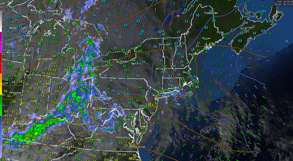
Winter Storm Warning for Orleans, Lamoille…& Winter Weather Advisory Washington, Caledonia, Essex Counties expire late overnight

TONIGHT: Mostly cloudy. Light accumulating snow and snow showers northern half of Vermont winding down later overnight with additional variable accumulation of dusting to 2” northern areas. Partly cloudy elsewhere. A low 20 to 25.

West to northwest winds 10 to 20 mph with some minor blowing and drifting.

TOMORROW: Scattered flurries northern areas, mainly in the morning with a dusting in spots, otherwise clouds with intervals of sun. A high around 25. West to northwest winds 10 to 20 mph.

FRIDAY NIGHT: Becoming mostly cloudy.Chance for light accumulating mountain snow showers and valley flurries. Less than an inch. A low around 10. Northwest winds 10 to 15 mph.

SATURDAY: Predominantly cloudy. Scattered mountain snow showers and flurries. Less than an inch. A high mid-teens. Northwest winds 10 to 20 mph.

Looking further ahead

SATURDAY NIGHT: Mostly cloudy.Scattered snow showers or flurries.Less than an inch. A low in the single digits.

SUNDAY: More clouds than sunshine. A chance for a lingering mountain flurry. A high in the low teens.

MONDAY: Partly to mostly cloudy. A low 5 below to 5 above. A high 10 to 15.

TUESDAY: Considerable cloudiness. Scattered snow showers or flurries with light accumulation. A low near 10. A high mid to upper teens.         

Average low 5 to 15. Average high mid-20s to about 30.

RH/1-2-25forecast][end]

An early winter weather system will push into the Green Mountain State later tonight while spreading rain valleys and mountain snowfall which will make things slippery. Progressively colder conditions will mean adding a new snow cover. Coldest weather late this weekend with below zero degree potential again at night.

Roger Hill’s Radio Vermont forecast 3:00 PM Tuesday 12-30-24

Winter Storm Watch late tonight thru Friday morning…

TONIGHT NEWS YEAR EVE: Fair this evening with high cloudiness thickening overnight. Wet snow…mixed with rain lowest valleys spreading south to north after 3 AM with slushy accumulations 1 to 3” with more southern Greens. A low in the low 30s. Light east to southeast winds.

TOMORROW NEW YEARS DAY: Gray. Rain lowest valleys, otherwise wet slushy snow accumulation 1 to 3”with locally more mountain summits. A high near 35. Winds becoming light and northerly.

WEDNESDAY NIGHT: Cloudy blustery and progressively colder. Accumulating snow or snow showers…most Green Mountain western slopes – couple 3 inches. A low mid to upper 20s. West to northwest winds 10 to 20 mph with higher gusts southern Greens.

THURSDAY: Mostly cloudy, blustery to windy with occasional mountain snow showers and valley flurries. About a dusting to 2 “accumulation. Temperatures mid to upper 20s. West to northwest winds 10 to 25 mph with higher gusts southern elevated terrain.

Looking further ahead

THURSDAY NIGHT: Lingering mountain snow showers & valley flurries with minor accumulations. A low in the upper teens.

FRIDAY: Partial morning sun, then lots of clouds. Scattered northern flurries. A high mid to upper 20s.

SATURDAY: Mainly gray. Scattered flurries. A low 5 to 10. A high low to mid-teens.

SUNDAY: Clouds mixing with periods of sunshine. A chance for a lingering mountain flurries. A low zero to 10 below, highs around 10 above.         

Average low 5 to 15. Average high mid-20s to about 30.

RH/12-30forecast][end]

Mild air with rain showers today continues tonight but with a quick intermission late today. Not bad tomorrow unless you like mid winter conditions as we’ll loose more snow. Snow returns to the high elevations 1st day of 2025 with a colder trend and slushy travel.

Roger Hill’s Radio Vermont forecast 3:00 PM Monday 12-30-24

TONIGHT: Clouding up this evening, leading to scattered rain showers. Mild with a low mid to upper 30s. Southwest winds 10 to 20 mph & gusty.

TOMORROW: Clouds with a few breaks of sun at times in the afternoon. A high mid-40s. Light south to southwest winds.

TUESDAY NIGHT NEWS YEAR EVE: Fair in the evening with high cloudiness, otherwise cloudy. Rain…mixed with wet snow accumulation likely 1 to 2” overnight south to north. A low 30 to 35. Light east winds.

WEDNESDAY NEW YEARS DAY: Gray. Rain likely predominates lower valleys, otherwise wet snow accumulation likely 1 to 3” up to locally 5” summits. Temperatures holding around 35. East winds 10 mph, becoming light and variable.

Looking further ahead

WEDNESDAY NIGHT: Cloudy blustery and progressively colder. Good chance for accumulating snow or snow showers…most Green Mountain western slopes – few inches. A low 25 to 30.

THURSDAY: Mostly cloudy, blustery to windy with occasional mountain snow showers and valley flurries. Minor accumulation. Temperatures falling thru the 20s.

FRIDAY: Partial morning sun, then lots of clouds with scattered lake effect flurries. A low 15 to 20. A high 25 to 30.

SATURDAY: Mainly gray. Scattered flurries. A low single digits. A high 10 to 15.               

Average low 5 to 15. Average high mid-20s to about 30.

RH/12-30forecast][end]

Sprawling high pressure will shift east as clouds pushing in ahead of the next weather system melt away as just high thin cirrus tonight, but gradually clouds thickening lead to sprinkles with an icy spot or two – heads up. Much warmer with rain and melting snows early to mid next week.

Roger Hill’s Radio Vermont forecast 3:00 PM Friday 12-27-24

TONIGHT: Some high cloudiness otherwise mostly clear. A low upper single digits to around 15 above. Little wind.

TOMORROW: Thickening clouds. Maybe a sprinkle or two central & southern areas. Maybe an icy spot. A high 35 to 40. Light southeast winds, but breezier Lake Champlain.

SATURDAY NIGHT: Cloudy. Chance for a sprinkle especially southern areas. Maybe an icy spot. A low 30 to 35. Light south winds, but breezier Lake Champlain.

SUNDAY: Gray. A rising likelihood for rain showers…shifting south to north. A high in the low 40s. Light southeast winds, but breezier Lake Champlain.

Looking further ahead

SUNDAY NIGHT: Lots of clouds with scattered light rain showers especially late. Becoming rather breezy western slopes. Milder. An early low near 40 rising toward 50 overnight.

MONDAY: Chance for rain showers…moderate at times mid-day. Otherwise gray & breezy to windy western slopes of Green Mountains…with partial clearing late. Above normal in temperature. A high upper 40s to around 50.

TUESDAY: Morning cloudiness, then increasing sunshine.A low near 35. A high near 40.

WEDNESDAY: Gray. Chance for rain…mixing with wet slushy snow…possibly significant in the mountains. A low near 30. A high mid to upper 30s.

Average low 5 to 15. Average high mid-20s to near 32.

RH/12-27forecast][end]

Monday Night Forecast — 12-23-24

Looking across the Champlain Valley from Mount Mansfield Vermont to Whiteface New York where there is a lot of great snow in the mountains for this Christmas Holiday with more to add tonight into tomorrow morning. Looking longer range – we may see a lot of our snow wane toward the New Year and beyond.

Roger Hill’s Radio Vermont forecast 3:00 PM Monday 12-23-24

Winter Weather Advisory thru 1 PM Tuesday…

TONIGHT: Overcast. Snow… moderate for a time. Temperatures holding in the low to mid-teens. South winds about 10 mph.

TOMORROW: Light snow or snow showers exit to a stray flurry or two. Total accumulation about 3 to locally 8” of fluff most in the Green Mountains less Champlain Valley. Otherwise, predominantly gray. Not so cold. A high in the mid-20s. Winds becoming light northwesterly

TUESDAY NIGHT CHJRISTMAS EVE: Lots of clouds with a stray mountain flurry. A low mid to upper single digits. Light north to northwest winds.

WEDNESDAY CHRISTMAS DAY: Morning clouds, then becoming mostly sunny. A high around 20. Light northwest wind.

Looking further ahead

WEDNESDAY NIGHT: Partly cloudy to mostly clear. Frigid again. A low 5 below to 5 above.

THURSDAY: A few mountain clouds early then mostly sunny. A high low to mid 20s.

FRIDAY: Sunshine with a few high clouds. Warming trend. A low zero to 5 above rebounding into the mid to upper 20s.

Average low about 5 to 15. Average high mid-20s to low 30s

RH/12-230forecast][end]

Thursday Night Forecast — 12-19-24

TONIGHT: Mainly cloudy. A low 10 to 15. Light northeast winds.

TOMORROW: Mainly gray. Scattered flurries develop in the afternoon with less than an inch of accumulation. A high of about 25. Light east winds.

Winter Solstice 4:21 AM

FRIDAY NIGHT: Lots of clouds. Scattered flurries…with less than an inch. A low in the mid-teens. Light north winds stronger near Lake Champlain.

SATURDAY: Lingering northern mountain flurries with little accumulation. Otherwise lots of clouds & colder. Temperatures holding in the mid to upper teens. Light northwest winds.

Looking further ahead

SATURDAY NIGHT: Considerable cloudiness with a few flurries drying up. A low 5 below to 5 above.

SUNDAY: A stray mountain flurry with lingering morning clouds, then increasing afternoon sunshine. Highs 5 to 10 above.

MONDAY: Mostly sunny with a few high clouds. A low zero to 10 below. A high 10 to 15.

TUESDAY: Cloudy skies with a chance for flurries…giving way to intervals of afternoon sun. A dusting in spots. A low in the single digits. A high 15 to 20.

Average lows upper single digits to mid-teens. Average high mid-20s to low 30s

RH/12-19forecast][end]

Wednesday Night Forecast — 12-18-24

TONIGHT: Cloudy. Occasional light wet snow with 1 to 2”…more mountain summits mixed with rain western Vermont valleys tapering to scattered flurries overnight.A low 30 to 32. Light west winds.

TOMORROW: Scattered mountain flurries mainly in the morning. Blustery & turning colder with temperatures falling thru the 20s. Northwest winds 10 to 20 mph.

THURSDAY NIGHT: Overcast with a stray mountain flurry. A low 10 to 15. Light northeast winds.

FRIDAY: Gray. Scattered snow shower activity with minor accumulation. A high about 25. Light east winds.

Looking further ahead

Winter Solstice 4:21 AM

FRIDAY NIGHT: Cloudy. Scattered light snow showers or flurries…dusting to an inch. A low mid-teens.

SATURDAY: Lingering northern mountain flurries with minor accumulation. Otherwise lots of clouds & progressively colder. Temperatures holding in the mid to upper teens.

SUNDAY: Lingering mountain cloudiness gives way to increasing sunshine in the afternoon. A low ranging 5 below to 5 above. Highs in the upper single digits.

MONDAY: Sunshine with a few high clouds. A low zero to 10 below. A high near 15.

Average lows upper single digits to mid-teens. Average high mid-20s to low 30s

RH/12-187forecast][end]

Tuesday Night Forecast — 12-17-24

Roger Hill’s Radio Vermont forecast 3:00 PM Tuesday 12-17-24

TONIGHT: Maybe a stray mountain flurry this evening, otherwise lots of clouds. A low in the upper 20s. West to southwest winds 10 to 15 mph.

TOMORROW: Gray skies and a little cooler. Chance for light wet snow…mixed with rain arriving toward dark. A high 35 to 40. Light southwest winds.

WEDNESDAY NIGHT: Clouds with breaks developing overnight. Occasional light wet snow mixed with rain western Vermont valleys. Dusting to 3 inches…most elevated terrain. A low about 30. Light west winds.

THURSDAY: A few sunny breaks in the morning then clouding up. A few widely scattered mountain flurries. Blustery at times & turning colder with temperatures falling thru the 20s. Northwest winds 10 to 15 mph.

Looking further ahead

THURSDAY NIGHT: Overcast. A low 10 to 15.

FRIDAY: Lots of clouds. Scattered snow shower activity with a dusting to an inch. A high 20 to 25.

SATURDAY: Considerable cloudiness & progressively colder with mountain flurries. A low in the low teens. A high about 15.

SUNDAY: Lingering mountain cloudiness in the morning, then increasing sun in the afternoon. A low ranging 5 below to 10 above.

Average lows upper single digits to mid-teens. Average high mid-20s to low 30s

RH/12-17forecast][end]

Monday Night Forecast — 12-16-24

Roger Hill’s Radio Vermont forecast 3:00 PM Monday 12-16-24

TONIGHT: Cloudy & gradually milder. Rising chance for rain showers with possible icy spots early. An early evening low in the mid-30s, rising toward 40 daybreak. Southeast winds 10 to 15 mph.

TOMORROW: Considerable cloudiness & milder. Passing sprinkles mixed with wet snow flakes late in the hills. A high in the mid-40s. Southwest winds 10 to 20 mph and gusty.

TUESDAY NIGHT: A few breaks in the clouds early otherwise cloudy. A stray flurry or two possible. A low around 30. West winds 10 to 15 mph.

WEDNESDAY: Gray skies and a little cooler. A high in the upper 30s. Light southwest winds.

Looking further ahead

WEDNESDAY NIGHT: Cloudy with a chance for occasional light snow mixed with rain lower valleys. A low near 30.

THURSDAY: Lingering clouds give way to late intervals of sun. Progressively colder. Temperatures falling thru the 20s.  

FRIDAY: Clouds with intervals of afternoon sun. Chance for light snow showers with minor accumulation. A low 10 to 15. A high low 20s.

SATURDAY: Considerable low cloudiness & progressively colder with mountain flurries. A low 5 to 10. A high in the low to mid-teens.

Average lows upper single digits to mid-teens. Average high mid-20s to low 30s

RH/12-16forecast][end]

Friday Night Forecast — 12-13-24

TONIGHT: Partly cloudy to mostly clear & moonlit skies. A low ranging 5 to 15 above. Light west winds.

TOMORROW: Morning clouds then lots of afternoon sunshine. Rather chilly. A high 20 to 25. Light northwest winds.

Full Cold Moon 4:02 AM

SATURDAY NIGHT: Mostly clear, moonlit & frigid. A low ranging 5 below to 10 above. Little wind.

SUNDAY: Sunshine becoming filtered through high clouds. A high mid to upper 20s. Light south winds.

Looking further ahead

SUNDAY NIGHT: Mainly cloudy. Chance for flurry southern areas. A low mid-teens to low 20s.

MONDAY: Variable cloudiness with more sunshine eastern areas. Seasonal temperatures. A high in the mid-30s.

TUESDAY: Gray. Chance for rain…moderate at times, tapering to scattered showers in the afternoon. Possible icy spots. An early low 32 to 35. A high in the mid-40s.

WEDNESDAY: Considerable mid and high cloudiness. A low in the low to mid 30s. A high around 35.

Average lows teens to near 20. Average high upper 20s to mid-30s

RH/12-13forecast][end]