Updated Tuesday Evening Forecast — April 9th, 2024

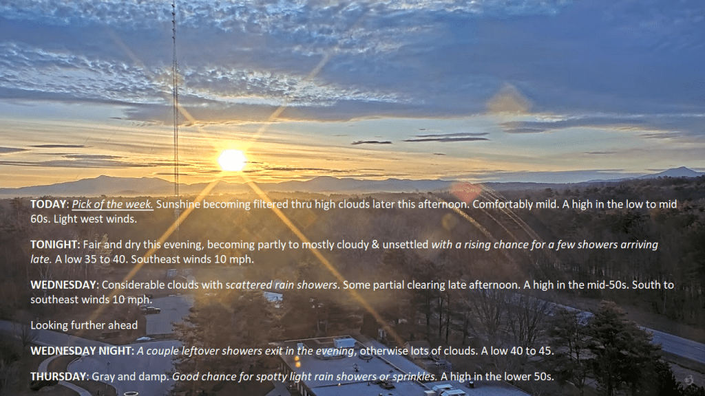
TONIGHT: Fair and dry this evening, becoming partly to mostly cloudy & unsettled with showers arriving late.A low 35 to 40. Southeast winds 10 mph.

TOMORROW: Considerable clouds with scattered rain showers. Some partial clearing late afternoon. A high in the mid-50s. South to southeast winds 10 mph but stronger near Lake Champlain.

WEDNESDAY NIGHT: A couple leftover showers exit in the evening, otherwise lots of clouds.A low 40 to 45. Southeast winds 10 mph.

THURSDAY: Gray and damp. Good chance for spotty light rain showers or sprinkles developing in the afternoon. A high in the lower 50s. Southeast winds 10 mph.

Looking further ahead

THURSDAY NIGHT: Cloudy & breezy to windy. Scattered rain showers.A low upper 40s. Southeasterly winds 10 to 15 mph.

FRIDAY: Overcast & breezy to windy western slopes of the Green Mountains. Chance for rain showers, moderate at times, maybe a rumble or two of thunder. A high 55 to 60.

SATURDAY: Brief morning sun, then cloudy. Chance for rain showers mixed with wet snowflakes higher terrain. A low in the lower 40s. A high 45 to 50.

SUNDAY: Mixed sun and clouds. Maybe a mountain sprinkle. A low 35 to 40. A high 50 to 55.

Average lows mid-20s to low 30s. Average 50 to 55

Start of meteorological summer June 6th

RH/4-9forecast][end]

Updated Tuesday Morning Forecast — April 9th, 2024

TODAY: Pick of the week. Sunshine becoming filtered thru high clouds later this afternoon. Comfortably mild. A high in the low to mid 60s. Light west winds.

TONIGHT: Fair and dry this evening, becoming partly to mostly cloudy & unsettled with a rising chance for a few showers arriving late.A low 35 to 40. Southeast winds 10 mph.

WEDNESDAY: Considerable clouds with scattered rain showers. Some partial clearing late afternoon. A high in the mid-50s. South to southeast winds 10 mph.

Looking further ahead

WEDNESDAY NIGHT: A couple leftover showers exit in the evening, otherwise lots of clouds.A low 40 to 45.

THURSDAY: Gray and damp. Good chance for spotty light rain showers or sprinkles. A high in the lower 50s.

FRIDAY: Overcast & breezy to windy western slopes of the Green Mountains. Chance for rain showers, moderate at times. A low upper 40s. A high 55 to 60. Gusty southeasterly winds.

SATURDAY: Brief morning sun, then cloudy. Chance for rain showers mixed with wet snowflakes higher terrain. A low in the lower 40s. A high 45 to 50.

SUNDAY: Mixed sun and clouds. Maybe a mountain sprinkle. A low 35 to 40. A high 50 to 55.

Average lows mid-20s to low 30s. Average 50 to 55

Start of meteorological summer June 6th

RH/4-9forecast][end]

Updated Monday Night Forecast — April 8th, 2024

TONIGHT: Partly cloudy. A low about 35. Light west winds.

TOMORROW: Sunshine filtered thru high clouds. Very mild. A high in the low to mid 60s. Light west winds.

TUESDAY NIGHT: Variable cloudiness and unsettled.A rising chance for a few showers arriving late.A low 35 to 40. Southeast winds 10 mph.

WEDNESDAY: Clouds with a few breaks of sun. Scattered rain showers. A high around 50. South to southeast winds 10 mph.

Looking further ahead

WEDNESDAY NIGHT: Cloudy.A couple leftover showers exit.A low 40 to 45.

THURSDAY: Gray and damp. Scattered rain showers. A high upper 40s to around 50.

FRIDAY: Clouds with a break or two of sun. Good chance for periods of rain or showers. A low upper 40s to around 50. A high around 60.

SATURDAY: Morning sun then lots of clouds. Chance for rain showers mixed with wet snow higher terrain late. A low in the lower 40s. A high 45 to 50.

Average lows mid-20s to low 30s. Average 50 to 55

Start of meteorological summer June 6th

RH/4-8forecast][end]

Updated Monday Morning Forecast — April 8th, 2024

TODAY: Sunshine becoming filtered thru high clouds this afternoon. Arrival of this cirrus clouds…about 2:30 to 3:30 PM with the eclipse 3:26 PM. A high near 55. Light northwest winds.

TONIGHT: Partly to mostly cloudy. A low about 35. Light west winds.

TUESDAY: Sunshine filtered thru high clouds. A high around 60. Light northwest winds.

Looking further ahead

TUESDAY NIGHT: Variable cloudiness and unsettled.Slight chance for a shower.A low mid to upper 30s.

WEDNESDAY: Clouds with intervals of afternoon sunshine. Scattered light afternoon rain showers. A high around 50.

THURSDAY: Gray and damp. Good chance for periods of rain or rain showers. A low 40 to 45. A high upper 40s to around 50.

FRIDAY: Clouds with a break or two of sun. Good chance for periods of rain or showers. A low 45 to 50. A high 55 to 60.

SATURDAY: Morning sun then lots of clouds. Chance for rain showers mixed with wet snow higher terrain late. A low near 40. A high in the mid-40s.

Average lows mid-20s to low 30s. Average 50 to 55

Start of meteorological summer June 6th

RH/4-8forecast][end]