Updated Friday Evening Forecast — April 12th, 2024

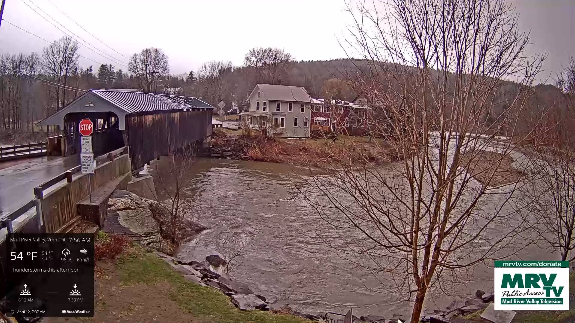
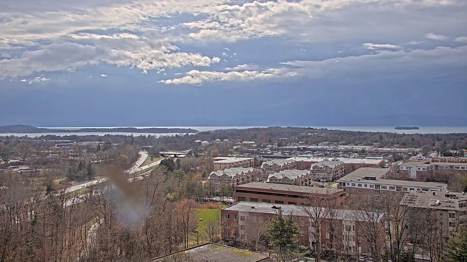
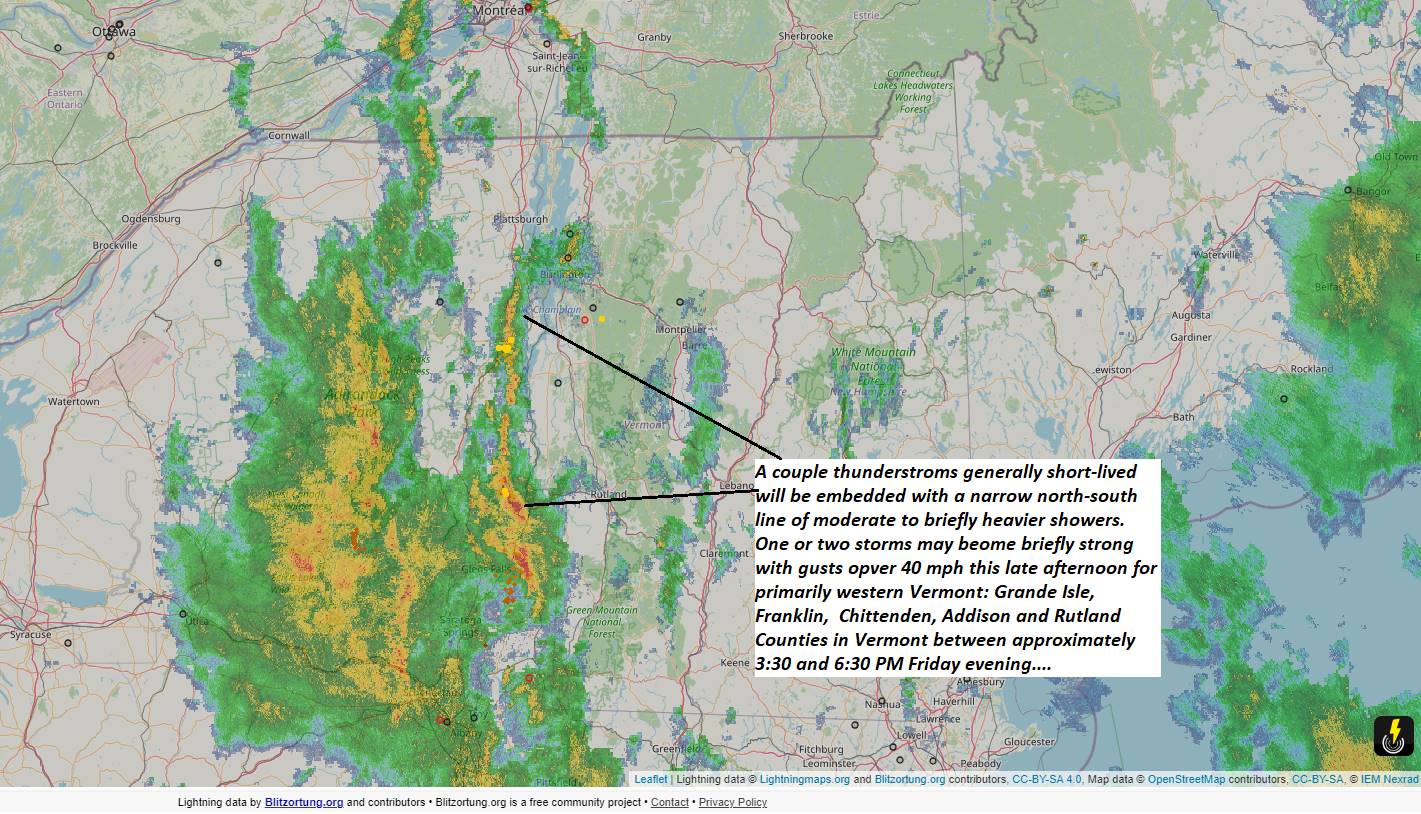
TONIGHT: Showers…moderate to briefly heavy with an isolated thunderstorm or two toward the Champlain valley early, thenbrief partial clearingwith an isolated shower overnight.A low 40 to 45. South to southwest winds 10 to 15 mph.

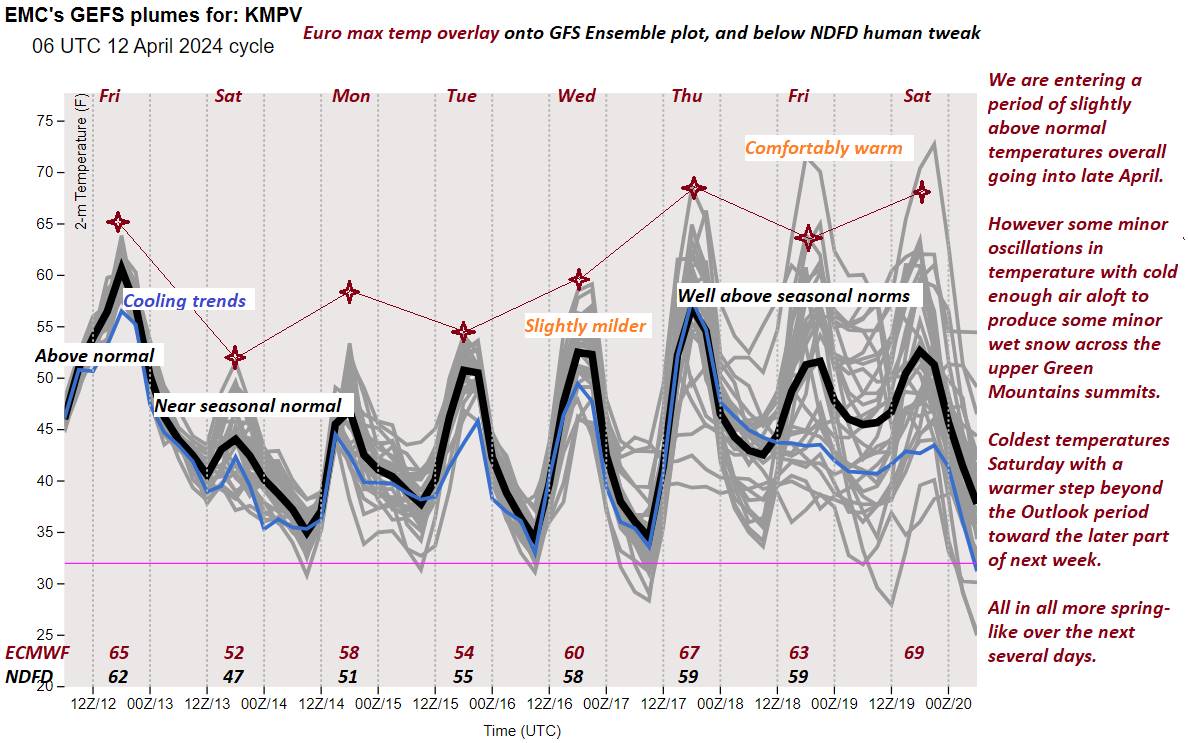
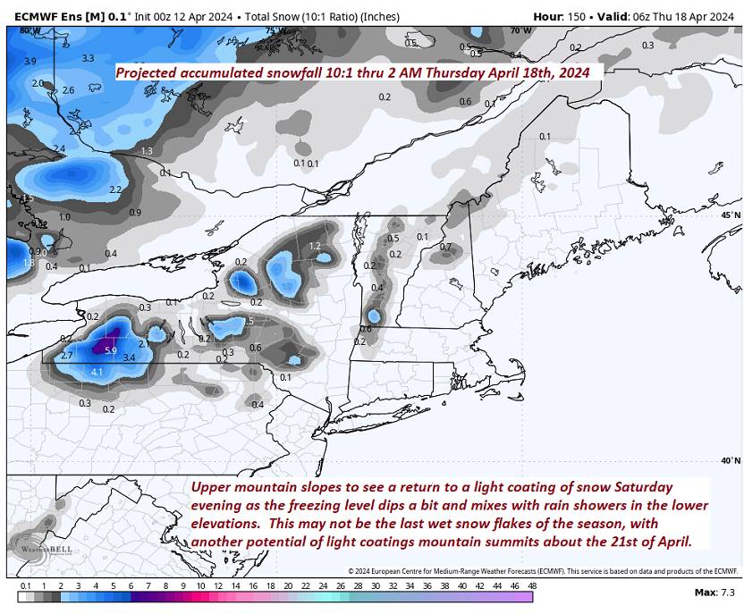
TOMORROW: Considerable cloudiness, blustery & cooler. Chance for rain showers…mixing with wet snowflakes higher terrain toward evening. A high 45 to 50. Winds southwesterly shifting to northwesterly 10 to 20 mph.

SATURDAY NIGHT: Lots of clouds, with scattered mountain showers of rain mixed with wet snow high terrain Partial overnight clearing. A low in the mid-30s. Southwest winds 10 to 15 mph.

SUNDAY: Morning sun, mixing with more clouds. Rising chance for late day showers western areas. A high mid to upper 50s. Northwest winds 10 mph.

Looking further ahead

SUNDAY NIGHT: Scattered evening showers, otherwise mostly cloudy.A low near 32 with scattered frost.

MONDAY: A possible rain shower toward evening, otherwise, clouds mixed with sun. A high near 55.

TUESDAY: Mostly sunny, with more afternoon clouds. A low about 32 with scattered frost. A high pushing to near 60.

WEDNESDAY: Partial morning sun, then thickening clouds. A low around 35. A high 65 to 70 degrees.

Average lows mid-20s to low 30s. Average 50 to 55

Start of meteorological summer June 6th

RH/4-12forecast][end]

Updated Friday Morning Forecast — April 12th, 2024

Wind Advisory expires at 2 PM central & northern Green Mountains, Champlain Valley & adjacent Washington Lamoille & Orleans Counties.

TODAY: Mainly cloudy, breezy to windy especially western slopes & milder. Rounds of rain showers, moderate to briefly heavy at times, with a rumble of thunder western areas later this afternoon. A high near 65 milder western areas to near 70. Southeast winds 10 to 25 mph gusts exceeding 40 mph western slopes Green Mountains thru this early afternoon.

TONIGHT: Showers and any storms early, exiting to brief clearing. Partly cloudyskies with a shower or two returning overnight.A low 40 to 45. South breeze 10 to 15 mph.

SATURDAY: Considerable cloudiness, blustery & cooler. Chance for rain showers…mixing with wet snowflakes higher terrain toward evening. A high 45 to 50. Winds shifting to westerly 10 to 20 mph.

Looking further ahead

SATURDAY NIGHT: Lots of clouds, with scattered mountain showers of rain and wet snow high elevations. A low in the mid-30s.

SUNDAY: Morning sun, mixing with more clouds. Rising chance for late day showers western areas. A high mid to upper 50s

MONDAY: A possible rain shower toward evening, otherwise, clouds mixed with sun. A low near 32 with scattered frost. A high near 55.

TUESDAY: Mostly sunny, with more afternoon clouds. A low about 32 with scattered frost. A high pushing to near 60.

WEDNESDAY: Partial morning sun, then thickening clouds. A low around 35. A high 65 to 70 degrees.

Average lows mid-20s to low 30s. Average 50 to 55

Start of meteorological summer June 6th

RH/4-12forecast][end]

Updated Thursday Evening Forecast — April 11th, 2024

TONIGHT: Cloudy & becoming breezy. Scattered sprinkles or light rain showers.A low 50 to 55 (Spotted Salamander migration?). Southeasterly breeze 10 to 20 mph stronger western Green Mountain slopes.

TOMORROW: Lots of clouds, breezy to windy especially western slopes & milder. Rounds of rain showers, moderate to briefly heavy at times, with a rumble of thunder western areas. A high 60 to 65. Southeast winds 10 to 20 mph stronger along western slopes of the Green Mountains.

FRIDAY NIGHT: Showers and any storms early, exiting to brief clearing. Partly cloudyskies with a shower or two returning overnight.A low 40 to 45. South breeze 10 to 15 mph.

SATURDAY: Considerable cloudiness & blustery & cooler. Chance for rain showers…mixing with wet snowflakes higher terrain toward evening. A high 45 to 50. Winds shifting to westerly 10 to 20 mph.

Looking further ahead

SATURDAY NIGHT: Lots of clouds, with scattered mountain showers of rain and wet snow high elevations. A low around 35.

SUNDAY: Sun mixing with more clouds. Slight chance for a late day shower far southern areas. A high in the mid-50s.

MONDAY: A possible rain shower toward evening, otherwise, variable cloudiness. A low in the low 30s with scattered frost. A high 50 to 55.

TUESDAY: Mostly sunny. A low in the low to mid 30s. A high pushing to near 60.

Average lows mid-20s to low 30s. Average 50 to 55

Start of meteorological summer June 6th

RH/4-11forecast][end]

Updated Thursday Morning Forecast — April 11th, 2024

TODAY: Gray and damp with areas of fog this morning. Light rain or rain showers developing late this morning. Mild.A high around 55. Southeast winds 10 to 15 mph in the afternoon.

TONIGHT: Cloudy & becoming breezy. Scattered sprinkles or light rain showers.A low about 50. Southeasterly winds 10 to 20 mph stronger across the western Green Mountain slopes.

FRIDAY: Gray & breezy to windy western slopes of the Green Mountains. Rain showers, moderate at times, with a rumble of thunder Champlain Valley late afternoon. A high about 60. Southeast winds 10 to 20 mph stronger along western slopes of the Green Mountains.

Looking further ahead

FRIDAY NIGHT: Brief clearing in the evening, then partly to mostly cloudy with a shower or two returning.A low around 40.

SATURDAY: Partial morning sun, then more clouds in the afternoon & blustery. Chance for rain showers…mixing with wet snowflakes higher terrain toward evening. A high just the middle 40s.

SUNDAY: Sun mixing with more clouds. Slight chance for a late day shower far southern areas. A low around 35. A high in the lower 50s.

MONDAY: A possible rain shower toward evening, otherwise, variable cloudiness. A low upper 30s. A high about 55.

TUESDAY: Mostly sunny. A low near 35 to 40. A high pushing to near 60.

Average lows mid-20s to low 30s. Average 50 to 55

Start of meteorological summer June 6th

RH/4-11forecast][end]

Updated Wednesday Evening Forecast — April 10th, 2024

TONIGHT: A couple leftover showers early, exiting in the evening, otherwise considerable cloudiness.A low 40 to 45. Light southeast winds.

TOMORROW: Gray and damp. Good chance for spotty light rain showers or sprinkles developing in the afternoon. A high around 55. Southeast winds 10 to 15 mph in the afternoon.

THURSDAY NIGHT: Cloudy & becoming breezy. Scattered rain showers.A low upper 40s. Southeasterly winds 10 to 20 mph.

FRIDAY: Gray & breezy to windy western slopes of the Green Mountains. Chance for rain showers, moderate at times, with a possible thunderstorm western areas late afternoon. A high in the low 60s. Southeast winds 10 to 20 mph stronger along western slopes of the Green Mountains.

Looking further ahead

FRIDAY NIGHT: Becoming mostly clear.A low upper 30s to around 40.

SATURDAY: Brief morning sun, then cloudy. Chance for rain showers mixed with wet snowflakes higher terrain. A high 45 to 50.

SUNDAY: More clouds than sunshine. Maybe a showers far northern areas. A low in the mid-30s. A high near 55.

MONDAY: Early cloudiness with a possible rain shower. Partly to mostly sunny. A low around 40. A high in the upper 50s to around 60.

Average lows mid-20s to low 30s. Average 50 to 55

Start of meteorological summer June 6th

RH/4-10forecast][end]

Updated Wednesday Morning Forecast — April 10th, 2024

TODAY: Lots of clouds. A couple of rounds of rain showers. Partial sunshine develops northern areas late this afternoon. A high in the upper 50s to around 60. South to southeast winds 10 mph but stronger near Lake Champlain.

TONIGHT: A couple leftover showers early, exiting in the evening, otherwise considerable cloudiness.A low 40 to 45. Light southeast winds.

THURSDAY: Gray and damp. Good chance for spotty light rain showers or sprinkles developing in the afternoon. A high around 55. Southeast winds 10 to 15 mph in the afternoon.

Looking further ahead

THURSDAY NIGHT: Cloudy & becoming breezy. Scattered rain showers.A low upper 40s. Southeasterly winds 10 to 20 mph.

FRIDAY: Gray & breezy to windy western slopes of the Green Mountains. Chance for rain showers, moderate at times, maybe a rumble or two of thunder western areas. A high in the low 60s.

SATURDAY: Brief morning sun, then cloudy. Chance for rain showers mixed with wet snowflakes higher terrain. A low upper 30s to around 40. A high 45 to 50.

SUNDAY: More clouds than sunshine. Maybe a showers far northern areas. A low in the mid-30s. A high near 55.

MONDAY: Early cloudiness with a possible rain shower. Partly to mostly sunny. A low around 40. A high in the upper 50s to around 60.

Average lows mid-20s to low 30s. Average 50 to 55

Start of meteorological summer June 6th

RH/4-10forecast][end]